
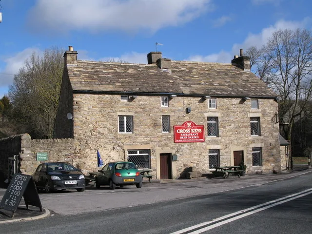
Cross Keys in Stanhope, County Durham
Cross Keys in County Durham, Stanhope is a pub (DL13 2HW) 🌐. Cross Keys is near Hag Bridge. Cross Keys also exists in Esh.
- Postal Code
- DL13 2HW
- Amenity
- pub
- Building Type
- building
- Website
- https://www.crosskeyseastgate.co.uk/index.html
Bus stops
Roads nearby
Hag Bridge600 m
Abandoned railways nearby
Rookhope and Middlehope RailwayMiddlehope Shield Mine and washing floor, Middlehope Shield Plants that live on lead, Middlehope Shield Geology of the area
2,4 km
Brownfields nearby
Former Eastgate Cement Works250 m
Buildings nearby
Spartalee House850 m
High Farm900 m
Horsley House1,4 km
Horsley High Cottage1,5 km
Sweet Wells1,9 km
West Newlandside2,4 km
Dike House2,4 km
Dike Barn2,8 km
Community centres nearby
Eastgate Village Hall200 m
Disused railways nearby
Weardale Railway250 m
Farmyards nearby
Cragside Farm200 m
Eastgate House550 m
Hole House1000 m
Sunderland Cleugh1,1 km
Rose Hill1,5 km
South Hanging Wells1,9 km
Ambling Gate1,9 km
Low Northgate2,0 km
North Hanging Wells2,0 km
Old Park House2,5 km
Forests nearby
Square Plantation850 m
Long Plantation1,3 km
Hostel nearby
Hiole House Bunkhouse950 m
Hotels nearby
Horsley Hall1,4 km
Houses nearby
High Bishopseat2,3 km
Places of worship nearby
All Saints200 m
Residential areas nearby
Hagg Bridge Caravan Park250 m
Cragside Caravan Park300 m
White House Caravan Park950 m
Weardale Holiday Lodges1,0 km
Rivers nearby
River Wear2,1 km
Streams nearby
Ludwell Burn1,3 km
Horsley Well1,3 km
Dry Gill1,7 km
Wittongill Sike2,0 km
Horsley Burn2,0 km
Brandon Cleugh Burn2,2 km
Snowhope Burn2,3 km
Blackcleugh Burn2,3 km
West White Well2,5 km
Yellock Sike2,6 km
Valleies nearby
Western Hope2,6 km
Woodlands nearby
Sunderland Cleugh Plantation1,6 km
Harelowcurrock Plantation2,0 km
Low Bishopseat Plantation2,1 km
Blackcleugh Plantation2,5 km
| Heritage designation | Grade II listed building |
|---|---|
| Located in | Stanhope |
| Country | United Kingdom |
 Public transport map Stanhope Legend
| Railway | |
| Bus | |
| Tram |
 Cycling map Stanhope Legend
| Cycle path | |
| Cycle lane on road | |
| Cycling on bus lane | |
| Bicycle street | |
| Cyclists allowed | |
| Cyclists allowed, good surface | |
| No cycling | |
| Cobblestones |
| Long-distance cycle route | (depending on scale) | |
| Long-distance cycle route |
 Walking map Stanhope Legend
| Path |
| Long-distance hiking trail | (depending on scale) | |
| Long-distance hiking trail | ||
| No pedestrians |