
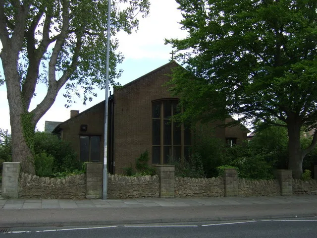
St. Chad's in City of Sunderland
St. Chad's in Sunderland is a Anglicana church, Durham Road (SR3 3LT). It belongs to the Diocese of Durham and is dedicated to Chad of Mercia.
- Postal Code
- SR3 3LT
- Street
- Durham Road
- Amenity
- place of worship
- Building Type
- building
Image
Roads nearby
Bridle Path100 m
Farrington Avenue150 m
SummerhillMiddle Herrington
200 m
Antwerp RoadANTWERP ROAD-S/B, Antwerp Road
200 m
Steep Hill200 m
Algiers Road250 m
Atlantis Road250 m
Carlton Crescent250 m
Tilbury Gardens250 m
Hillcrest250 m
Berkeley Close250 m
Beckwith Road300 m
Charter DriveCairnside Post Office
300 m
Lambton Court300 m
Andrew Road350 m
Arkle Road350 m
Raby Drive350 m
Lumley Court350 m
Munslow Road350 m
Townsend Road350 m
Lulworth Court400 m
Avonmouth Square400 m
St Chad's Road400 m
St Chad's Crescent400 m
Ashdown RoadASHDOWN ROAD-ALLENDALE ROAD-W/B, ASHDOWN ROAD-ANTWERP ROAD-S/B, Farringdon Post Office, The Local Butcher
450 m
Tenby Road450 m
Tasman Road450 m
Careen CrescentLondis
450 m
Salter Lane450 m
Thames Road500 m
Theme Road500 m
Avalon Road550 m
Tuscan Road550 m
Tilbury RoadTILBURY ROAD-THORNE ROAD-S/B, TILBURY ROAD-TAY ROAD-N/B, TILBURY ROAD-THISTLE ROAD-S/B
550 m
Durham RoadDurham Road-Stoney Gate, Durham Road - Board Inn, Saints, North Moor, Barnes Car Sales, Barnes Convenience Store, Queen Alexandra Road - Durham Road, East Herrington Board Inn, Durham Road-Dunelm South, Durham Road, Subway, Durham Road-Riversdale Terrace, DURHAM ROAD-EDEN HOUSE ROAD-N/B, Houghton-le-Spring, Houghton Cuts, ST. MICHAEL'S RC. PRIMARY SCHOOL, Durham Road - Stoney Gate (N/B), Durham Road - Parkside Farm (N/B), Durham Road-Beckwith Road, DURHAM ROAD-ST CHADS-SW/B, Durham Road-Bridal Path, Durham Road - Bede Centre (E/B), Durham Road - Parkside, Durham Road-West Park, Durham Road-Parkside Farm, Durham Road-Over The Hill Farm, Durham Road - Bede Centre (W/B), Amber’s, Buyrite, China Wok, Aroma Spice, Barber Kings, Golden Fry, Prospect Lidl, Barnes Park, BARNES PARK, Prospect, Durham Road-Parkside South
600 m
Turnham Road650 m
Thorne Road700 m
Thorne SquareTHORNE ROAD-E/B
700 m
Thurso Close750 m
Tintagel Close750 m
Thistle RoadThorney Close
750 m
Trent Road800 m
Trevelyan Close800 m
Tadcaster RoadTADCASTER ROAD-S/B, Suntrap, Nisa Local
850 m
Commercial areas nearby
Foxcover Filling Station450 m
Convenience stores nearby
Nisa Local400 m
Dental practices nearby
mydentist100 m
Petrol stations nearby
Jet450 m
Pubs nearby
The Dolphin400 m
| Dedicated to | Chad of Mercia |
|---|---|
| Diocese | Diocese of Durham |
| Located in | Sunderland |
| Country | United Kingdom |
 Public transport map Sunderland Legend
| Railway | |
| Bus | |
| Tram |
 Cycling map Sunderland Legend
| Cycle path | |
| Cycle lane on road | |
| Cycling on bus lane | |
| Bicycle street | |
| Cyclists allowed | |
| Cyclists allowed, good surface | |
| No cycling | |
| Cobblestones |
| Long-distance cycle route | (depending on scale) | |
| Long-distance cycle route |
 Walking map Sunderland Legend
| Path |
| Long-distance hiking trail | (depending on scale) | |
| Long-distance hiking trail | ||
| No pedestrians |