
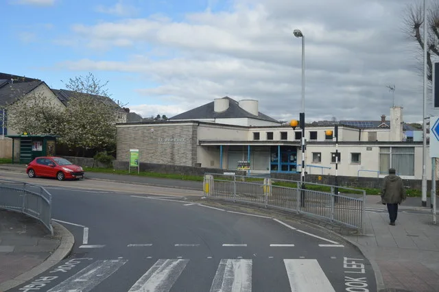
St Budeaux Library in Plymouth
St Budeaux Library in Plymouth is a library (Plymouth City Council), Victoria Road (PL5 1RQ).
- Postal Code
- PL5 1RQ
- Street
- Victoria Road
- Amenity
- library
- Building Type
- building
- Operator
- Plymouth City Council
Bus stops
Stations
Post offices
Pharmacy
Doctor's office
Car repair shops
Roads nearby
Victoria RoadVictoria Road Library, Roman Way, Row Lane, Victoria Road Top, Bickham Road, Victoria Road (Bottom), Evelyn Street, Victoria Road Evelyn Street, Family Shopper, Victoria Road Tennis Courts, Verna Road
50 m
Trelawney AvenueSt Budeaux
100 m
Percy Street100 m
Trelawney PlaceSt Budeaux Victoria Road
100 m
Wolseley RoadGulf, Queens House, Wolseley Road, St Budeaux Post Office, St Budeaux Square, St Budeaux Ferry Road, Camels Head Dockyard, Ferry Road Station, St. Budeaux Junction, Lidl, KFC, D&W Auto Services MOT Centre, Lidls, Saltash Passage, Saltash Road, Ferry House Inn, Little Ash Gardens, Little Ash Road, Ford Shops, Tesco Express, North Down Crescent, Wolseley Home, North Prospect Library, Harbour Avenue, Harbor Avenue, Weston Mill Primary School, Camels Head Post Office, Cookworthy Road, Austin Avenue, Vicarage Gardens, Wolseley Road Sub-Station
100 m
Pemros RoadSt Paul's Church, MacKenzie Place, Mackenzie Place, Stanhope Road, Saltburn Road
100 m
Barne Lane150 m
Florence Street200 m
Coldrenick Street250 m
Poole Park RoadBarne Barton Primary School, Poole Park Road, Rugby Pitch, Wilkinson Road
250 m
Woodstock GardensWell Pharmacy, Ocean Health Group
300 m
Sithney Street300 m
Bridge View300 m
Barne RoadBrunel View
400 m
Westcroft Road400 m
Rennie Avenue400 m
Haydon Grove400 m
Landulph Gardens400 m
Ivanhoe RoadOld Youngie
400 m
Trafalgar Close450 m
Seacroft Road450 m
Ark Royal Close450 m
Landrake Close450 m
Old School Road450 m
Old Farm Road500 m
Saltburn Road500 m
Stirling Court500 m
Kit Hill Crescent500 m
Kiln Close500 m
Stirling Road550 m
Stanhope Road550 m
Loftus Gardens550 m
Kurnow Gate550 m
Tenby Road550 m
Beauty salons nearby
Consol100 m
Cafés nearby
Honey's100 m
Charity shops nearby
Hannah's100 m
Convenience stores nearby
Co-op Food50 m
Double J Mini-Market350 m
Fast food restaurants nearby
Pizza Hut Delivery100 m
Ivor Dewdney Pasties100 m
Drake's Plaice200 m
Gift shops nearby
It's on the Cards100 m
Parks nearby
Seacroft Childrens park400 m
Pharmacies nearby
Well Pharmacy100 m
Places of worship nearby
St Boniface Church100 m
Restaurants nearby
Taste of India200 m
Retail buildings nearby
Fulfords100 m
Co-operative Funeral Care250 m
| Inception | 1963 |
|---|---|
| Elevation | 28.8 m |
| Located in | Plymouth |
| Country | United Kingdom |
| Website | https://www.plymouth.gov.uk/libraries/findlibraryandopeninghours/stbudeauxlibrary |
 Public transport map Plymouth Legend
| Railway | |
| Bus | |
| Tram |
 Cycling map Plymouth Legend
| Cycle path | |
| Cycle lane on road | |
| Cycling on bus lane | |
| Bicycle street | |
| Cyclists allowed | |
| Cyclists allowed, good surface | |
| No cycling | |
| Cobblestones |
| Long-distance cycle route | (depending on scale) | |
| Long-distance cycle route |
 Walking map Plymouth Legend
| Path |
| Long-distance hiking trail | (depending on scale) | |
| Long-distance hiking trail | ||
| No pedestrians |