
St Budeaux in Plymouth
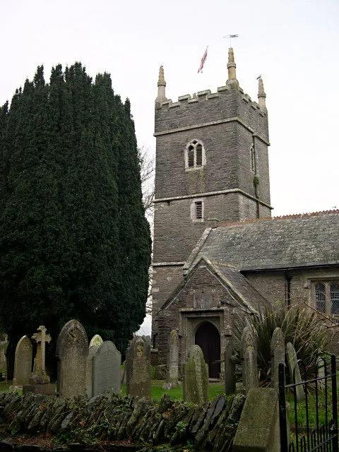
St Budeaux in Plymouth is a Anglicana church. It is near Dalton Gardens and is also known as St Budeaux Parish Church. The church belongs to the Diocese of Exeter and is dedicated to St Budeaux. It is a listed building.
- Amenity
- place of worship
- Building Type
- church
- Website
- https://www.st-budeaux-church.co.uk/
Image
Bus stops
Roads nearby
Kinsale Road250 m
Perranporth Close250 m
Victoria RoadVictoria Road Library, Roman Way, Row Lane, Victoria Road Top, Bickham Road, Victoria Road (Bottom), Evelyn Street, Victoria Road Evelyn Street, Family Shopper, Victoria Road Tennis Courts, Verna Road
250 m
Roman WayPriestley Avenue, Plaistow School
250 m
Marett Road300 m
Budshead RoadMarina Road, Dayton Close, Bodmin Road West, Canterbury Drive, Budshead Road West, Westbury Close, Whitleigh Cross, Budshead Green, Kirkwall Road Top, Lancaster Gardens, Bodmin Road East, Whitleigh Court, Warwick Avenue, Albemarle, Budshead Road Bungalows, Ringmore Way, Milford Lane, Rodger's Garage, Budshead Road Filling Station, Londis, Bethany Evangelical Church
300 m
Dalton Gardens300 m
Culdrose Close300 m
Ernesettle LaneErnesettle Lane Top, Ernesettle Lane RNAD, Ernesettle Crescent
300 m
Priestley Avenue300 m
Acklington Place350 m
Dunstone Road350 m
Yelverton Close350 m
Jubilee Road350 m
Ernesettle Road350 m
Redhill Close400 m
Agaton Road400 m
Newman Road400 m
Plaistow Close400 m
Crownhill RoadCrownhill Road Playing Fields, West Park Shops, Crownhill Fire Station, Little Dock Lane, Woodland Fort, Old Woodland Road West, Old Woodlands Road, St Peter's Road, Haroldsleigh Avenue, Jet Garage, Crownhill High Level, Ringmore Way, St Budeaux Church, Marrett Road, Carroll Road, Kirkwall Road
400 m
Marina Road450 m
Ernesettle Crescent450 m
The ParkwaySt Budeaux, Weston Mill, Marsh Mills Roundabout, Manadon Roundabout, Forder Valley Interchange, The Cabin Childcare Centre
450 m
Mollison Road500 m
Hill Top Crest550 m
King's Tamerton RoadFlamstead Crescent, Kings Tamerton Road, Flamsteed Crescent
550 m
Plaistow Crescent550 m
Buckingham Place600 m
Row Lane600 m
Stephenson Way600 m
Clifford Close650 m
Bickham Road650 m
Mount Tamar Close650 m
Newton Avenue650 m
Howard Close700 m
Cayley Way700 m
Rorkes Close700 m
Trevithick RoadMarine Academy
750 m
Leisure nearby
Agaton Social Club350 m
Allotment gardens nearby
St Budeaux Church Allotments50 m
Buildings nearby
DVSA Driving Test Centre350 m
Churches nearby
Kingdom Hall of Jahova's Witnesses300 m
Community centres nearby
St Budeaux Church Community Hall150 m
King's Tamerton Community Centre600 m
Dental practices nearby
Victoria Road Dental Labratory450 m
Houses nearby
Clifford's Funeral Directors450 m
Nature reserves nearby
Kings Tamerton Wood (Local Nature Reserve)450 m
Social facilities nearby
Ernstell House Care Home300 m
Sports centres nearby
The Parkway Sports and Social Club450 m
| Dedicated to | St Budeaux |
|---|---|
| Diocese | Diocese of Exeter |
| Heritage designation | Grade II* listed building |
| Located in | City of Plymouth |
| Country | United Kingdom |
 Public transport map Plymouth Legend
| Railway | |
| Bus | |
| Tram |
 Cycling map Plymouth Legend
| Cycle path | |
| Cycle lane on road | |
| Cycling on bus lane | |
| Bicycle street | |
| Cyclists allowed | |
| Cyclists allowed, good surface | |
| No cycling | |
| Cobblestones |
| Long-distance cycle route | (depending on scale) | |
| Long-distance cycle route |
 Walking map Plymouth Legend
| Path |
| Long-distance hiking trail | (depending on scale) | |
| Long-distance hiking trail | ||
| No pedestrians |