
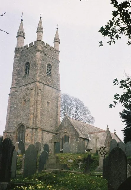
St Edward's Church in Plymouth
St Edward's Church in Plymouth is a Anglicana church. It is near Shirburn Road and is also known as St Edward's Church, Eggbuckland. The church belongs to the Diocese of Exeter and is a listed building.
- Amenity
- place of worship
- Building Type
- church
Image
Bus stops
Roads nearby
Church HillMiles Mitchell Avenue, St Edwards church, Eggbuckland, Church Hill Garages, Woodland, Mayfair Crescent
50 m
Farm LaneThe Prince Maurice
100 m
Hayes PlaceEggbuckland Fish & Chips
100 m
Dudley Gardens150 m
Rose Cottages150 m
Doidges Farm Close150 m
Goosewell Hill250 m
Coltsfield Close250 m
Shirburn Road250 m
Billington Close300 m
St. Edward Gardens300 m
Bearsdown Road300 m
Frogmore AvenueVassos Patisseries
350 m
Cameron Way350 m
Eggbuckland RoadPearn Home, Deer Park Drive, Rosevean Gardens Shops, Eastfield Crescent, Cranmere road, The Vale, Shallowford Road, Bluebird, Higher Compton, Bloomball Close, Windsor Road, Petersfield Close, Donnington Drive, Bowhays Walk, Frogmore Avenue, Rose Cottages, Elm Grove, St Edwards church, Mannamead Tennis Club, Collins Park
350 m
Cox's Close350 m
Kingswear Crescent350 m
Charfield DriveBridgwater Close, Huxham Close, Brooking Close, Bellamy Close, Ditton Court
350 m
Langmead Road400 m
Kimberly Drive400 m
Carisbrooke Road400 m
Frogmore Court400 m
Langmead Close400 m
Cardigan Road450 m
Bearsdown Close450 m
Linketty Lane East450 m
Bridgwater Close450 m
Aldersley Walk450 m
Shallowford RoadShallowford Road Shops, Shallowford Road Top, Shallowford Road Bottom
450 m
Forder Valley Road450 m
Shipley Walk450 m
Mayfair Crescent500 m
Ducane Walk500 m
Forder Heights500 m
Fort Austin AvenueShirburn Road, Fort Austin Avenue, Forder Heights, Fort Austin Garden Centre, Widey Cross, Widey Lane, Fort Austin Shops, Inpost
500 m
Miles Mitchell Avenue500 m
Bircham ViewBircham View
600 m
Moat Park650 m
Austin CrescentBircham View South, Sutton Garage, Childrey Gardens, Dunley Walk
700 m
Barcote Walk700 m
Childrey Walk750 m
Childrey Gardens750 m
Dunley Walk750 m
Baydon Close800 m
Buildings nearby
Eggbuckland Keep400 m
Convenience stores nearby
Eggbuckland Stores200 m
Co-op Fort Austin550 m
Garden centres nearby
Plymouth Garden Centre600 m
Playgrounds nearby
Frogmore Green350 m
| Diocese | Diocese of Exeter |
|---|---|
| Heritage designation | Grade II* listed building |
| Located in | City of Plymouth |
| Country | United Kingdom |
 Public transport map Plymouth Legend
| Railway | |
| Bus | |
| Tram |
 Cycling map Plymouth Legend
| Cycle path | |
| Cycle lane on road | |
| Cycling on bus lane | |
| Bicycle street | |
| Cyclists allowed | |
| Cyclists allowed, good surface | |
| No cycling | |
| Cobblestones |
| Long-distance cycle route | (depending on scale) | |
| Long-distance cycle route |
 Walking map Plymouth Legend
| Path |
| Long-distance hiking trail | (depending on scale) | |
| Long-distance hiking trail | ||
| No pedestrians |