
The Swallow in Plymouth
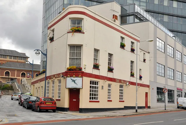
The Swallow in Plymouth is a pub, Bretonside (PL4 0BD).
- Postal Code
- PL4 0BD
- Street
- Bretonside
- Amenity
- pub
- Building Type
- retail building
Image
Cafés
Fast food restaurants
Pharmacy
Restaurants
Bar
Bus stops
Convenience stores
Places of worship
Bank
Roads nearby
North Street Subway50 m
Lower Street50 m
Hawkers Avenue100 m
Exeter StreetExeter Street, Turtle Bay, Viaduct, St John's Church, Zizzi, Brewdog, Boom Battle Bar, Kaspa's, Charles Church, Friary Park
100 m
North Quay100 m
Harbour Avenue150 m
Gasking StreetTesco Express
150 m
Friary Street200 m
Beaumont RoadCarmarthen Road, Heathfield Road, The Venton Centre, Astor Drive, Mount Gould, Beaumont Villa Surgery, St Judes Church, Gasking Street, Friary Mill, Friary Surgery, Durham Avenue, Jephson Road
200 m
Beaumont Place200 m
Park Terrace200 m
North East QuayDaisy's Tea Rooms and Coffee Shop, Honkey Tonk!, Handelsbanken
200 m
Gascoyne Place250 m
Whitefriars Lane250 m
East Quay North300 m
East Quay SouthSuphas Street Food Emporium
300 m
Sutton RoadInPost, China House
300 m
Marrowbone Slip350 m
Lipson RoadSea View Avenue, Seymour Road, Freedom Park
350 m
Friary Retail ParkDunelm, Poundstretcher, Smyths, Hobbycraft, Pets at Home, Poundland, Costa
350 m
DIY stores nearby
Screwfix300 m
Shops nearby
Brandon Hire Station350 m
Apartment buildings nearby
Bretonside Court100 m
Discovery Wharf100 m
Pinnacle Quay North150 m
Pinnacle Quay South200 m
Harbour Arch Quay200 m
Gascoyne Court200 m
Exeter Street Flats250 m
Regent House350 m
Brownfields nearby
Sugar Quay300 m
Buildings nearby
Jobcentre Plus50 m
Centre Court100 m
Car repair shops nearby
Halfords Autocentre200 m
Exeter Street Garage350 m
Convenience stores nearby
Premier350 m
Detached houses nearby
Nash & Co250 m
Fast food restaurants nearby
Domino's100 m
New Jade Garden200 m
Hi-fi shops nearby
Richer Sounds150 m
Office buildings nearby
West Point150 m
Parks nearby
Beaumont Park250 m
Petrol stations nearby
Asda150 m
Pubs nearby
The Woodside200 m
Restaurants nearby
Miller & Carter350 m
Retail buildings nearby
Minerva Cafe and Clothing50 m
Slipwaies nearby
Marrowbone Slip - Public slipway for small boats300 m
Specialist shops nearby
Jewson200 m
Tyre shops nearby
Save on Tyres350 m
| Located in | City of Plymouth |
|---|---|
| Country | United Kingdom |
| Location | Plymouth |
 Public transport map Plymouth Legend
| Railway | |
| Bus | |
| Tram |
 Cycling map Plymouth Legend
| Cycle path | |
| Cycle lane on road | |
| Cycling on bus lane | |
| Bicycle street | |
| Cyclists allowed | |
| Cyclists allowed, good surface | |
| No cycling | |
| Cobblestones |
| Long-distance cycle route | (depending on scale) | |
| Long-distance cycle route |
 Walking map Plymouth Legend
| Path |
| Long-distance hiking trail | (depending on scale) | |
| Long-distance hiking trail | ||
| No pedestrians |