
The Tap & Barrel in Plymouth
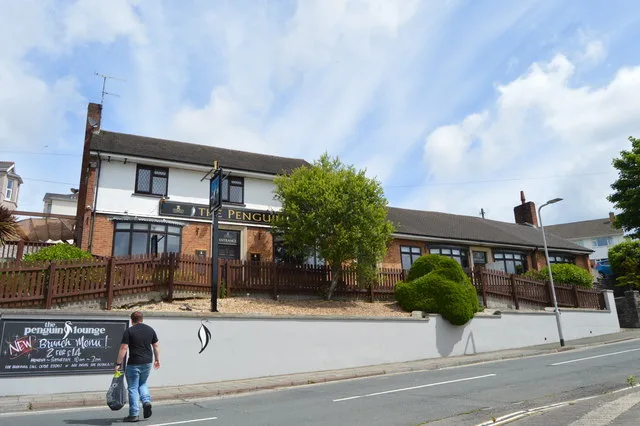
The Tap & Barrel in Plymouth is a pub. The Tap & Barrel is also known as Penguin. The Tap & Barrel is near Michael Road.
- Amenity
- pub
- Building Type
- building
Image
Bus stops
Roads nearby
Ashford Road Lane North50 m
Ashford Hill50 m
Bute Road50 m
Bute Road Lane50 m
Elm Crescent100 m
Rutland Road Lane East100 m
Arlington Road100 m
Rutland Road150 m
Edgar Terrace150 m
Holkham Lane150 m
Rutland Road Lane West150 m
Bradley Road150 m
Castleton Close200 m
Turret Grove Lane East200 m
Ashford CrescentElm Crescent, Ashford Close
200 m
Rockingham RoadRockingham Road Bottom, Rockingham Road Top
200 m
Bradley Road Lane200 m
Ashford Road250 m
Turret Grove250 m
Alexandra RoadAshford Hill, Crozier Road, Toasted Bar, Todays Kebab, Focus Barbers, Alexandra Road, Marina Terrace
250 m
Ashford CloseLipson Vale
250 m
Ivydale Road Lane East250 m
West Hill RoadWest Hill Road
250 m
Michael Road250 m
Penrose Villas250 m
Seymour Road250 m
Ivydale Road300 m
Crow Park300 m
Glen RoadGlen Road Subway, Glenside Surgey, Lord Louis, Tory Brook, Kingston Drive, Plympton, Parkstone Lane, Westfield, District Centre, The Co-operative Food, Glen Park Primary School, Hickory Drive, Edwards Drive
300 m
BBC Plymouth carpark350 m
Hillsborough350 m
carpark350 m
Courtfield Road400 m
Seymour Park400 m
Culme Road450 m
Apartment buildings nearby
St Augustine's House150 m
Car repair shops nearby
Nick's Motors100 m
Kwik Fit Plus150 m
Neil & Thompson Motors350 m
Car washes nearby
Super Hand Car Wash150 m
Convenience stores nearby
Tesco Express150 m
Fast food restaurants nearby
The Backstreet Spot250 m
Houses nearby
Unique Building and Roofing Contractors300 m
Outdoor seatings nearby
Tap & Barrel Beer Garden50 m
Railway lines nearby
South Devon Main Line100 m
Residential areas nearby
Alexandra Works200 m
Service buildings nearby
Ashford Hill Substation50 m
Social facilities nearby
Mayflower House450 m
Studios nearby
BBC Broadcasting House350 m
| Located in | City of Plymouth |
|---|---|
| Street address | Ashford Crescent, Mutley, Devon, PL3 5AA |
| Postal code | PL3 5AA |
| Country | United Kingdom |
| Location | Mutley |
 Public transport map Plymouth Legend
| Railway | |
| Bus | |
| Tram |
 Cycling map Plymouth Legend
| Cycle path | |
| Cycle lane on road | |
| Cycling on bus lane | |
| Bicycle street | |
| Cyclists allowed | |
| Cyclists allowed, good surface | |
| No cycling | |
| Cobblestones |
| Long-distance cycle route | (depending on scale) | |
| Long-distance cycle route |
 Walking map Plymouth Legend
| Path |
| Long-distance hiking trail | (depending on scale) | |
| Long-distance hiking trail | ||
| No pedestrians |