
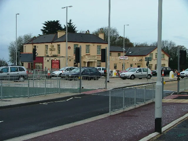
Toby Carvery in Plymouth
Toby Carvery in Plymouth is a restaurant (British, outdoor seating, vegetarian options, wheelchair accessible), Tavistock Road 399 (PL6 7HB). Toby Carvery is also known as The George. Toby Carvery also exists in Southend-on-Sea, Portsmouth, Warrington, Stoke-on-Trent and Cumberland.
- House Number
- 399
- Postal Code
- PL6 7HB
- Street
- Tavistock Road
- Amenity
- restaurant
- Building Type
- building
- Website
- https://www.tobycarvery.co.uk/restaurants/south-west/roboroughplymouth
- Wheelchair Access
- yes
Image
Bus stops
Roads nearby
Southway DriveSouthway Drive Steps, Oakwood Primary School, Southway Valley Nature Reserve, Southway Drive, Clittaford Road, Rockfield Footpath, Pandeen Crescent, Southway Shops, Friary Mill, Southway Fish and Chips, British Red Cross, Morrisons Daily, Coral, St Luke's Hospice, Southway Charcoal Grill, Indian Kitchen, Salon 323, Southway Pizza, Well Pharmacy, Butler Close, Southway Lane, Southway Drive Path, Roborough Surgery, Southway Drive Surgery
100 m
Morgan RoadMorgan Road Westbound, Morgan Road Eastbound
100 m
Southway Lane100 m
Tavistock RoadPowisland Drive, Tavistock Road Woolwell, Roborough Footbridge, Woolwell Roundabout, Windsor House, Crownhill Fort, Derriford Retail Park, Tavistock Road, George Junction, Great Berry Road, George Hotel, Jack Rabbit, Tavistock Road Powisland Drive, Charlton Road, Tesco Pharmacy, Vision Express, St Boniface's College, Derriford Roundabout, Crownhill Low Level (South Bound), William Prance Road, Roborough Bypass
100 m
Eastcote Close150 m
Brockton Gardens250 m
Olympic WayThe George Park & Ride boarding
250 m
Colston Close250 m
Tylney Close250 m
Buena Vista Drive250 m
The Court300 m
Plymbridge RoadGlenfield Road, Blue Haze Close, Plymbridge Road Factories, Rowse Electrical Wholesalers Limited, Toolstation, Marsh Mills Post Office, Crossway, Plymbridge Road, Fine Tubes
300 m
Abney Crescent350 m
Corsham Close350 m
Frensham Avenue350 m
Little Fancy Close350 m
Oldlands Close350 m
Widewell Road400 m
Barndale CrescentColston Close, Burton Close, Corsham Close
400 m
Davenham Close400 m
Cromwell Gate400 m
Coringdean Close400 m
Burton Close400 m
Farnley Close400 m
Arley Close400 m
Frewin Gardens450 m
Trentham Close450 m
Boundary Place450 m
Butler Close450 m
Hazel Close450 m
Barningham Gardens500 m
Launceston Close500 m
Frensham Gardens550 m
Clittaford RoadClittaford Road, Samuel Basset Avenue, Pentland Close, Amelia's boutique, Lundy Close, Skerries Road, Southway Curry and Kebab, Premier Clittaford, The Falstaff, Flamborough Road, Langley Crescent
600 m
Hedingham Gardens650 m
Riflemans Walk650 m
Prestonbury Close650 m
Highclere Gardens650 m
Samuel Bassett Avenue650 m
Holne Chase650 m
Widewell Lane700 m
Lulworth DriveHedingham Gardens
700 m
Beverston WayLegis Walk, Wardour Walk
700 m
Wardour Walk700 m
Car dealerships nearby
Turners Of Roborough300 m
Doctor's practice nearby
Roborough Surgery150 m
Hotels nearby
Travelodge Roborough50 m
School buildings nearby
Oakwood500 m
Woodlands nearby
Widewell Woods700 m
| Located in | City of Plymouth |
|---|---|
| Country | United Kingdom |
| Location | Roborough |
 Public transport map Plymouth Legend
| Railway | |
| Bus | |
| Tram |
 Cycling map Plymouth Legend
| Cycle path | |
| Cycle lane on road | |
| Cycling on bus lane | |
| Bicycle street | |
| Cyclists allowed | |
| Cyclists allowed, good surface | |
| No cycling | |
| Cobblestones |
| Long-distance cycle route | (depending on scale) | |
| Long-distance cycle route |
 Walking map Plymouth Legend
| Path |
| Long-distance hiking trail | (depending on scale) | |
| Long-distance hiking trail | ||
| No pedestrians |