
All Saints in Hooton Pagnell
All Saints in Hooton Pagnell in Doncaster is a Anglicana church. It is near Clayton Lane and is also known as All Saints' Church, Hooton Pagnell. The church belongs to the Diocese of Sheffield and is dedicated to All Saints' Day. It was built in 1150 and is a listed building. All Saints also exists in Owston.
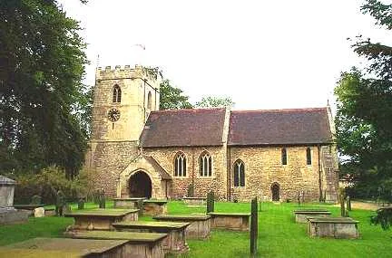
- Amenity
- place of worship
- Building Type
- church
Roads nearby
Clayton LaneHooton Pagnell
200 m
Back Lane350 m
Butt Lane500 m
White Lane950 m
Elmsall Lane1,1 km
Watchley Lane1,2 km
Lound Lane1,3 km
Old Street1,4 km
Street Lane1,5 km
Hooton RoadBrodsworth Road/Hooton Road, Hooton Road/Street Lane
1,6 km
Northfield Road1,7 km
Lenny Balk1,8 km
Bilham Lane1,8 km
Red Hill Lane2,4 km
Stotfold Road2,4 km
Churchfield RoadChurch Field Road/Hooton Pagnell Common
2,5 km
Chapel Lane2,5 km
Abandoned railways nearby
Wath Branch1,5 km
Frickley Colliery Branch1,9 km
Buildings nearby
Frickley Hall1,8 km
Bilham Belvedere1,9 km
Archery Pavilion2,0 km
Commons nearby
South Elmsall Common2,1 km
Farmyards nearby
Billham Grange Farm1,3 km
Home Farm2,0 km
Forests nearby
Bread Walls Plantation700 m
Bilham Wood1,2 km
L PLantation1,7 km
Summer House Plantation1,9 km
Home Plantation2,0 km
Golf courses nearby
Hickleton Golf Club2,5 km
Nature reserves nearby
Bilham Sand Pits SSSI1,3 km
Places of worship nearby
All Saints Church (Frickley and Clayton)1,7 km
Pubs nearby
1903350 m
Residential areas nearby
Hooton Pagnell Hall250 m
Ruins nearby
Brodsworth Hall Eyecatcher2,1 km
Streams nearby
Frickley Beck1,7 km
Thurnscoe Dike2,3 km
Woodlands nearby
First Plantation400 m
Second Plantation500 m
Third Plantation850 m
Bluegate Flatt Plantation900 m
Hooton Pagnell Wood1000 m
The Ashes1,1 km
Black Plantation1,2 km
Fish Pond Plantation1,3 km
The Wilderness1,5 km
Hooton Thorn Covert1,7 km
Mill Race Plantation1,8 km
| Inception | 1150 |
|---|---|
| Dedicated to | All Saints' Day |
| Diocese | Diocese of Sheffield |
| Heritage designation | Grade I listed building |
| Located in | Hooton Pagnell |
| Country | United Kingdom |
 Public transport map Hooton Pagnell Legend
| Railway | |
| Bus | |
| Tram |
 Cycling map Hooton Pagnell Legend
| Cycle path | |
| Cycle lane on road | |
| Cycling on bus lane | |
| Bicycle street | |
| Cyclists allowed | |
| Cyclists allowed, good surface | |
| No cycling | |
| Cobblestones |
| Long-distance cycle route | (depending on scale) | |
| Long-distance cycle route |
 Walking map Hooton Pagnell Legend
| Path |
| Long-distance hiking trail | (depending on scale) | |
| Long-distance hiking trail | ||
| No pedestrians |