
Image
Roads nearby
Chapel StreetGreasbrough, Ship Inn
100 m
Wentworth Court100 m
Baulk Farm Close100 m
Fitzwilliam Square150 m
Green Street150 m
Booth Street150 m
Mill Street200 m
Milton Close200 m
New Street250 m
The Balk250 m
Croft Street250 m
Main StreetMain Street/The Statutes, Main Street/New York Way
250 m
The WhinsCinder Bridge Road/Harold Croft, Cinder Bridge Road/Church Street, The Whins/Cinder Bridge Road
300 m
Coach RoadCoach Road
300 m
Campbell Street300 m
Old School Close300 m
Greasbrough Park350 m
Fenton RoadFenton Road/Munsbrough Rise, Fenton Road/Coach Road, Fenton Road/Fenton Fields, Fenton Road/Fenton Croft, Fenton Road/Hudsons Rough, Fenton Road/Bradgate Road, Fenton Road/Wortley Road
400 m
Park View400 m
Potter HillPotter Hill/Highfield Road, Potter Hill/Lowfield Avenue, Potter Hill/Firth Street, Potter Hill/Scrooby Street, Potter Hill/Munsbrough Lane, Potter Hill/Coach Road
400 m
Greenside400 m
Fitzwilliam WalkThe Co-operative Food
450 m
Jackson Way450 m
Munsbrough RiseMunsbrough Rise/Greenside, Munsbrough Rise/Munsbrough Lane, Munsbrough Rise/Wagon Road
550 m
Roughwood RoadRoughwood Road/Wingfield Road, Roughwood Road/Grayson Road, Roughwood Road/Ox Close Avenue, Roughwood Road/Spring Croft, Roughwood Road/Ten Acre Road, Ring O Bells, Kimberworth Park, Roughwood Road/Rhodes Avenue, Roughwood Road/Crane Road, Roughwood Road/Remount Road, Roughwood Road/Roughwood Way, Roughwood Road/Wensleydale Road, The Plough, Roughwood Road/Wheatley Road, Roughwood Road/Hudson Road
550 m
Wagon RoadWagon Road/Coppice Gardens, Wagon Road/Briery Walk, Wagon Road/Woodside Walk, Wagon Road/Acorn Croft, Wagon Road/Oak Lea
550 m
Grayson RoadGrayson Road/Roughwood Road, Grayson Road/Whitehall Road, Graysons Road/Church Street
600 m
Wingfield Close650 m
Treefield Close700 m
Goodwin RoadGraysons Road/Goodwin Road
700 m
Whitehall RoadWhitehall Road/Library Close, Whitehall Road/Town Lane, The Mill Dam
700 m
Loy Close700 m
Library CloseWingfield Post Office
750 m
Amenities nearby
Tiny Tots400 m
Body of waters nearby
Mill Dam500 m
Buildings nearby
Greasbrough Working Mens Club150 m
Car dealerships nearby
Effingham Road Motor Co.400 m
Convenience stores nearby
Main Street Convenience Store250 m
Fast food restaurants nearby
The Sandwich Shop300 m
Gardens nearby
33 Main Street300 m
35 Main Street (owned by 33 Main Street)300 m
Houses nearby
1 Rossiter Road300 m
Libraries nearby
Greasbrough Library300 m
Parks nearby
Greasborough Field350 m
Pubs nearby
Crown Inn400 m
Social facilities nearby
Greenside Court300 m
Sports pitches nearby
Greasbrough Park Crown Green Bowls Club350 m
Streams nearby
Ochre Dike350 m
Woodlands nearby
Wilcox's Plantation500 m
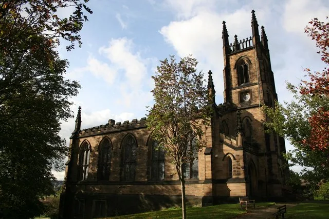
| Diocese | Diocese of Sheffield |
|---|---|
| Heritage designation | Grade II listed building |
| Located in | Rotherham |
| Country | United Kingdom |
 Public transport map Rotherham Legend
| Railway | |
| Bus | |
| Tram |
 Cycling map Rotherham Legend
| Cycle path | |
| Cycle lane on road | |
| Cycling on bus lane | |
| Bicycle street | |
| Cyclists allowed | |
| Cyclists allowed, good surface | |
| No cycling | |
| Cobblestones |
| Long-distance cycle route | (depending on scale) | |
| Long-distance cycle route |
 Walking map Rotherham Legend
| Path |
| Long-distance hiking trail | (depending on scale) | |
| Long-distance hiking trail | ||
| No pedestrians |