
St Cecilia in Sheffield
St Cecilia in Sheffield is a Anglicana church. It is near Deerlands Mount.
- Amenity
- place of worship
- Building Type
- building
Image
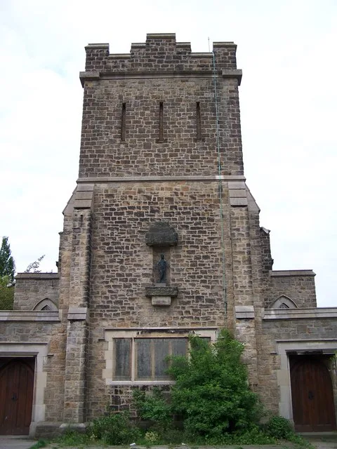
Roads nearby
Chaucer Close100 m
Deerlands AvenueDeerlands Avenue/Deerlands Mount, Deerlands Avenue/Halifax Road, Deerlands Avenue/Holgate Avenue, Deerlands Avenue/Adlington Road, Deerlands Avenue/Holgate Crescent, Phoenix Social Club, Deerlands Avenue/Barnsley Road, Deerlands Avenue/Ingelow Avenue, Deerlands Avenue/Lindsey Road, Deerlands Avenue/Lindsay Road, Deerlands Avenue/Buchanan Crescent, Deerlands Avenue/Wordsworth Avenue, Chaucer, Deerlands Avenue/Wordsworth Ave, Asda Café
150 m
Deerlands Mount200 m
Chaucer RoadChaucer Road/Chaucer Close, Chaucer Road/Halifax Road, Chaucer Road/Deerlands Avenue, Chaucer Road/Fulmere Road, Chaucer Road/Mansel Crescent, Chaucer Road/Yew Lane, Mansel Primary
200 m
Halifax RoadHalifax Road/Southey Green Road, Halifax Road/Wilcox Road, Halifax Road Dental Care, Halifax Road/Parson Cross Road, Halifax Road/Deerlands Avenue, Halifax Road/Chaucer Road, Halifax Road/Carrville Drive, Halifax Road/Doe Royd Lane, Halifax Road/Cowper Crescent, Wadsley Bridge W.M.C., Halifax Road/Lyminster Road, Halifax Road/Fox Hill Road
200 m
Cowper AvenueCowper Avenue/Owen Close, Cowper Avenue/Cowper Drive, Cowper Avenue/Owen Walk, Cowper Avenue/Grimsell Crescent
250 m
Mansel Road300 m
Mansel CrescentWoolley Wood School
300 m
Wilcox Close350 m
Mansel Avenue350 m
Wordsworth AvenueWordsworth Avenue/Deerlands Avenue, Wordsworth Avenue/Milnrow Road, Wordsworth Avenue/Doe Royd Lane, Wordsworth Avenue/Southey Hill, Wordsworth Avenue/Wordsworth Crescent, Wordsworth Avenue/Southey Green Road, Wordsworth Avenue/Monteney Road, Wordsworth Avenue/Turie Crescent, Wordsworth Avenue/Remington Road, Wordsworth Avenue/Donovan Road, Wordsworth Avenue/Cookson Road, Wordsworth Avenue/Herries Road, Wordsworth Avenue/Margetson Crescent, Wordsworth Avenue/Tunwell Avenue, Wordsworth Avenue/Wheata Place, Wordsworth Avenue/Wheata Drive, Wordsworth Avenue/Monteney Crescent, Parson Cross, Asda
350 m
Wordsworth Close350 m
Cowper Crescent350 m
Cowper Drive400 m
Fulmere Crescent400 m
Fulmere Road450 m
Doe Royd Crescent500 m
Doe Royd Drive500 m
Lytton Crescent550 m
Doe Royd Lane550 m
Buchanan RoadParson Cross Pharmacy
550 m
Deerlands Close600 m
Buchanan Drive600 m
Knutton Rise600 m
Lytton Road600 m
Knutton Crescent600 m
Margetson Drive650 m
Milnrow Drive650 m
Milnrow Road700 m
Buchanan Crescent700 m
Milnrow View700 m
Austen Road750 m
Dugdale Road750 m
Knutton Road750 m
Lytton Drive750 m
Lytton Court750 m
Margetson CrescentDickory Dock Nursery, Margetson Crescent/Knutton Road, Colley, Parson Cross Forum
750 m
Convenience stores nearby
Londis400 m
Morrisons Daily800 m
Frozen food shops nearby
Farmfoods350 m
Funeral directors nearby
Peace Funerals250 m
Libraries nearby
The Learning Zone400 m
Parks nearby
Wolfe Road Park350 m
Petrol stations nearby
Parson Cross Filling Station400 m
Pubs nearby
Eight Foot Way250 m
The Beagle600 m
Streams nearby
Tongue Gutter600 m
Supermarkets nearby
Asda250 m
Heron Foods750 m
| Located in | Sheffield |
|---|---|
| Country | United Kingdom |
| Location | Parson Cross |
 Public transport map Sheffield Legend
| Railway | |
| Bus | |
| Tram |
 Cycling map Sheffield Legend
| Cycle path | |
| Cycle lane on road | |
| Cycling on bus lane | |
| Bicycle street | |
| Cyclists allowed | |
| Cyclists allowed, good surface | |
| No cycling | |
| Cobblestones |
| Long-distance cycle route | (depending on scale) | |
| Long-distance cycle route |
 Walking map Sheffield Legend
| Path |
| Long-distance hiking trail | (depending on scale) | |
| Long-distance hiking trail | ||
| No pedestrians |