
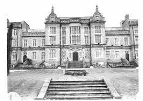
All Saints House in Birmingham
All Saints House in Birmingham is a building (listed building) (B18 4BJ). All Saints House is near Beaumont Gardens. All Saints House also exists in Greater London. Ⓦ.
- Postal Code
- B18 4BJ
- Building Type
- building
Image
Roads nearby
Asylum Bridge150 m
Winson Green Prison Bridge200 m
Rectory Grove250 m
Kirby Road250 m
Winson Green Wharf Bridge250 m
Norman StreetCentre of the Earth
250 m
Beaumont Gardens250 m
Victor Road300 m
Villiers Street300 m
Magdala Street300 m
Peel Street300 m
Handsworth New RoadHandsworth New Rd / Willes Rd, Handsworth New Rd / Lodge Rd, Handsworth New Rd / Winson Green Metro Stop
300 m
Merediths Pool Close350 m
Spring Grove Gardens350 m
Central Park Drive350 m
Chandlers Close350 m
Ansbro Close350 m
Markby Road350 m
Carlisle Street400 m
Clinton Street400 m
Blackford Street400 m
Preston Road400 m
Aberdeen StreetCM, CL, Birmingham City Hospital
400 m
Merry Hill Drive400 m
Heartland Close400 m
Bryant Street400 m
Navigation Way400 m
Winson Green RoadWinson Green Rd / Winson Green Prison, Winson Green Rd / Foundry Rd, Winson Green Road, Winson Green Rd / Heath St, Winson Green Rd / Aberdeen St
400 m
Willes RoadWinson Green
400 m
Waterside Drive450 m
Talbot Street450 m
Augustine Grove450 m
Berry Drive450 m
Lees Street500 m
Lodge RoadAs Saffar, KS Tuition Centre, Lodge Rd / Musgrave Rd, Lodge Rd / Bacchus Road, Lodge Rd / Winson Green Prison, Gate No 6, Lodge Rd / All Saints St, Lodge Rd / Bredon Croft, Lodge Rd / Norton St
500 m
Great Western Close500 m
Devonshire Avenue500 m
Bacchus Road550 m
Benson RoadSoho, Benson Road
550 m
Canals nearby
Soho Loop Canal250 m
Convenience stores nearby
Winson Green Convenience350 m
Parks nearby
All Saints Park250 m
Musgrave Road Recreation Ground550 m
Places of worship nearby
Lodge Road Church Centre450 m
The Beulah Hills Apostolic Church500 m
Pubs nearby
The Acorn250 m
Devonshire Arms300 m
Railway lines nearby
Didcot and Chester Line550 m
Tram lines nearby
Midland Metro550 m
| Inception | 1850 |
|---|---|
| Located in | Winson Green |
| Country | United Kingdom |
 Public transport map Birmingham Legend
| Railway | |
| Bus | |
| Tram |
 Cycling map Birmingham Legend
| Cycle path | |
| Cycle lane on road | |
| Cycling on bus lane | |
| Bicycle street | |
| Cyclists allowed | |
| Cyclists allowed, good surface | |
| No cycling | |
| Cobblestones |
| Long-distance cycle route | (depending on scale) | |
| Long-distance cycle route |
 Walking map Birmingham Legend
| Path |
| Long-distance hiking trail | (depending on scale) | |
| Long-distance hiking trail | ||
| No pedestrians |