
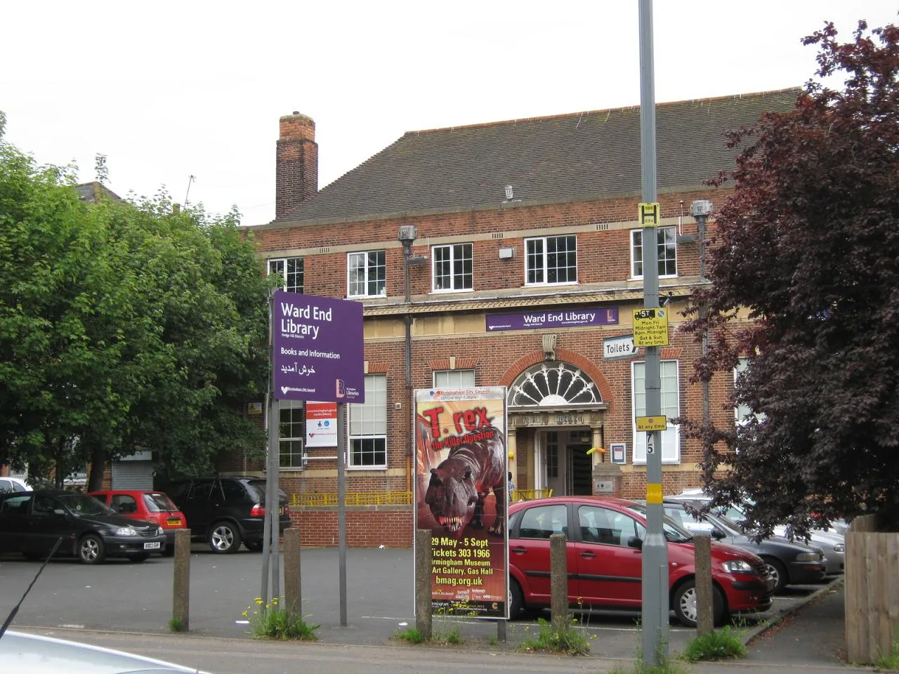
Ward End Public Library in Birmingham
Ward End Public Library in Birmingham is a library (Birmingham City Council). Ward End Public Library is near Parkway.
- Amenity
- library
- Building Type
- building
- Operator
- Birmingham City Council
Image
Roads nearby
Wallbank Court100 m
Church WalkWard End Elim Church, Aston & Nechells Foodbank
150 m
Wallbank Road150 m
Washwood Heath RoadWashwood Heath Rd / Library, Urban Cycles, Washwood Heath Rd / Hutton Rd, Washwood Heath Rd / Sandway Gardens, Ali Hairdressers, Ariana Fresh Naan, Bani's, Blooming Buds nurseey, Body 1st Nutrition, C&P Autos, Chamtarr, Chicks, Docunlock.com, Read 2 Lead, Shango's, Shinka, Stratford Beacon College, Studio 244, Surpreme House, Taz's Convenience Store, Twilight Phones, Waheed Grocers, William Hill, Islamic Cultural Study Centre, K Fish & Chips, K.B.Bargains, Kami, Kool Kids, Pak Asia Cargo Service (UK) Ltd., Phone Shop, Washwood Heath Rd / Saltley Gate, Hand Car Wash, Ruby's, Sana Collections, Taza Tandoori Roti & Curry Restaurant, La Calin, Circular Dance (Saltley Interchange), Washwood Heath Rd / Foley Rd, Washwood Heath Rd / Twyford Rd, Washwood Heath Rd / Sladefield Rd, Washwood Heath Rd / St Agatha'S Rd, Al Furqan, AMC Autos, Paddy Power, Kundun, Eye Care, UK & Fired Chicken, Jimmy's, Silver Scissors, Greggs, N.A. Halal Poultry, Subhaan Global Travel, International Mini Market, Phone Rescue UK, Mobile City, Naveed News, Dixy Chicken, Pamir, Magdalena Restaurant, Kurdish Naan, Frizeria Sebi, Queens Beautique, Stavros, Bismillah Bakery, Pearl Medical Centre, Ward End Pharmacy, Istanbul Fashion, Smart Cleaners, Sunrise Carpets & Floorings, Hair & Beauty Salon, La Nella, Da Fabiano, Rak-Uniforms, Attari's Discount Store, Oakland, Waqas's Cutz, Yuen Tung, Halal Meat, Seasonz, Fashion Point, Madina, Petals of Madinah, Smart Computer Systems, Brits Hair & Beauty, Waseem's, NRS, specs direct, Daanyaal Kebab House, SK Pizza & Kebab, Romanesc Tarancuta, Casa Romanesca, Bucuresti Magazin, Habz, Nexgen, Watan Mini Market, Filling Hutz, Laugh 'n' Learn Day Nursery, Finest Desserts, Marwan, Salon HQ, Antalya Shawarma, Pizza Quarter, Kashmiri King Karahi, Washwood Heath Rd / Wright Rd, Washwood Heath Rd / Highfield Rd, Washwood Heath Rd / Common Lane, Washwood Heath Rd / Drews Lane, Direct MOT Centre, Sidhu News, WD, WF
150 m
St Margarets RoadRenown Motor Engineers, Lifestyle Express, Drinks Express, Salvage Plant Hire, T.K. Tyres
200 m
Overpool Road200 m
Parkview Drive250 m
Schoolgate Close250 m
Perrins Grove250 m
Coronation RoadCoronation Rd / Rookery Rd, Dawlish Rd / Selly Hill Rd
450 m
Ward End Close450 m
Parkway500 m
Sladefield Road500 m
Garden Close500 m
Sunnydene550 m
Park View Close550 m
Millthorpe Close550 m
Ward Close550 m
Wagoners Close550 m
Woodcote Drive550 m
Ravenfield Close550 m
Pound Green600 m
Ward End Park Road600 m
Swan CloseTyrebase
600 m
Watson RoadWatson Rd / Star City Terminus
650 m
Lime Tree Road650 m
Tranter Road650 m
Glen Park Road650 m
Foxton Road650 m
Thurcroft Close700 m
Community centres nearby
Ward End Asian Elders Welfare Association500 m
Dental practices nearby
Ward End Dental Practice50 m
Fire stations nearby
Ward End Fire Station100 m
Gardens nearby
Ward End Park Community & Schools Garden150 m
Money transfer offices nearby
Shpun Remit100 m
Nightclubs nearby
Maitland Hall50 m
Opticians nearby
T Cox150 m
Parks nearby
Ward End Park450 m
Places of worship nearby
Jakia Masjid Naqsbandia Aslamia & Community Centre50 m
Ward End Full Gospel Church Centre150 m
St Margaret150 m
Bethel Free Baptist Church350 m
Railway lines nearby
Stechford and Aston Line500 m
Residential buildings nearby
Ward End House100 m
Essington House450 m
Social facilities nearby
Dolphin Centre300 m
Sports pitches nearby
Ward End Conservative & Washwood Heath Crown Green Bowling Club100 m
Ward End Social Crown Green Bowling Club150 m
Supermarkets nearby
Food World350 m
| Elevation | 104.1 m |
|---|---|
| Located in | Birmingham |
| Street address | Ward End Library, Washwood Heath Road, Birmingham, B8 2HF |
| Postal code | B8 2HF |
| Country | United Kingdom |
| Location | Birmingham |
 Public transport map Birmingham Legend
| Railway | |
| Bus | |
| Tram |
 Cycling map Birmingham Legend
| Cycle path | |
| Cycle lane on road | |
| Cycling on bus lane | |
| Bicycle street | |
| Cyclists allowed | |
| Cyclists allowed, good surface | |
| No cycling | |
| Cobblestones |
| Long-distance cycle route | (depending on scale) | |
| Long-distance cycle route |
 Walking map Birmingham Legend
| Path |
| Long-distance hiking trail | (depending on scale) | |
| Long-distance hiking trail | ||
| No pedestrians |