
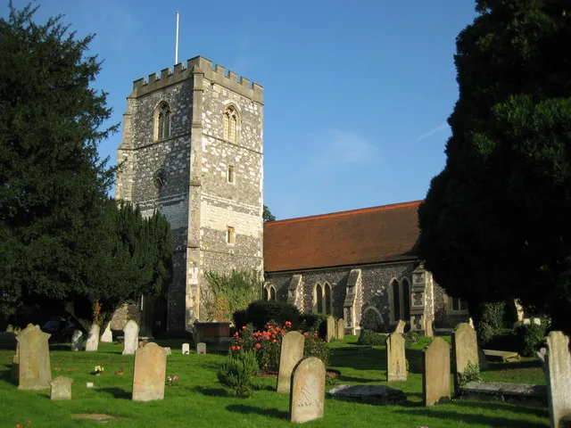
Saint Michael's in Bray, Berkshire
Saint Michael's in Windsor and Maidenhead, Bray is a Anglicana church (SL6 2AF). It is near Brayfield Road and is also known as St Michael's Church, Bray. The church belongs to the Diocese of Oxford and is dedicated to Michael. It is a listed building. Ⓦ.
- Postal Code
- SL6 2AF
- Amenity
- place of worship
- Building Type
- church
Image
Fast food restaurants
Convenience stores
Bus stops
Restaurants
Places of worship
Roads nearby
Vicarage Drive100 m
Church Lane100 m
Church Drive100 m
West Court150 m
Bettoney Vere200 m
Ferry RoadThe Waterside Inn
200 m
Brayfield Road200 m
Old Mill LaneBray, Caldesi in Campagna
250 m
Bray Close250 m
The Terrace250 m
High StreetVillage Hall
300 m
Bray RoadThe Fat Duck, Chiltern Road, Hibbert Road Playing Field
300 m
Hanover Mead350 m
Braybank400 m
Beaufort Place450 m
Bray Bridge450 m
Church Road550 m
River Gardens550 m
Fishery Road600 m
Green Lane600 m
Hibbert Road650 m
The Causeway650 m
Glebe Road650 m
Upper Bray RoadHastings Close
650 m
The Binghams700 m
Taplow FP 17Bargefield Cottage
750 m
Gas LaneGreggs
800 m
Canon Hill Drive800 m
Avenue Road800 m
Cannon Hill Close850 m
Amerden Lane850 m
Buildings nearby
The Ringers Public House150 m
Body of waters nearby
Bray Lock850 m
Buildings nearby
Club House250 m
Braywick Nature Centre700 m
Community centres nearby
Bray Village Hall250 m
Farmyards nearby
Barge Farm650 m
Gardens nearby
Jesus Hospital Almshouses300 m
Nature reserves nearby
Braywick Park650 m
Petrol stations nearby
Esso800 m
Pubs nearby
The Hinds Head100 m
The Crown300 m
Recreation grounds nearby
Maidenhead & Bray Sports Club150 m
Braywick Sports Centre800 m
Residential areas nearby
Hanover Housing Association450 m
Rivers nearby
The Cut400 m
River Thames750 m
Weirs nearby
Bray Weir800 m
Woodlands nearby
Headpile Eyot350 m
| Dedicated to | Michael |
|---|---|
| Diocese | Diocese of Oxford |
| Heritage designation | Grade II* listed building |
| Located in | Bray |
| Country | United Kingdom |
| Website | http://www.braystmichael.co.uk |
 Public transport map Bray Legend
| Railway | |
| Bus | |
| Tram |
 Cycling map Bray Legend
| Cycle path | |
| Cycle lane on road | |
| Cycling on bus lane | |
| Bicycle street | |
| Cyclists allowed | |
| Cyclists allowed, good surface | |
| No cycling | |
| Cobblestones |
| Long-distance cycle route | (depending on scale) | |
| Long-distance cycle route |
 Walking map Bray Legend
| Path |
| Long-distance hiking trail | (depending on scale) | |
| Long-distance hiking trail | ||
| No pedestrians |