
Girdwood Airport in Girdwood, AK 99587
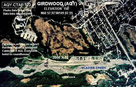
Girdwood Airport in Girdwood, AK 99587 (Anchorage) is an airfield (IATA: AQY). Girdwood Airport is also known as AQY. Ⓦ.
Image
Clinics
Marketplaces
Theaters
Charging stations
Stations
Ice cream shops
Tourist information centers
Campgrounds
Attractions
Bus stops
Boutiques
Restaurants
Cafes
Pubs
Libraries
Liquor stores
Platforms
Drugstores
Fast food restaurants
Streets nearby
Lake Tahoe Road400 ft
Lake Tahoe Circle500 ft
Deb's Way0.1 mi
Donner Drive0.1 mi
Banff Circle0.2 mi
Fernie Loop0.2 mi
Hightower RoadGirdwood, The Grind
0.2 mi
Davos Road0.2 mi
Alyeska Highway0.3 mi
Alpine Meadows Avenue0.3 mi
Cortina Road0.3 mi
Lindblad AvenueGirdwood Health Clinic
0.3 mi
Aspen Mountain Road0.4 mi
Holmgren Place0.4 mi
Tanner Circle0.4 mi
Crow Creek Highway0.5 mi
Innsbruck Road0.5 mi
Brighton Road0.5 mi
Arlberg AvenueChargePoint, Mt.Alyeska Tram
0.5 mi
Garmisch Road0.5 mi
Powder Drive0.5 mi
Crystal Mountain Road0.6 mi
Taos Road0.6 mi
Olympic Mountain Loop0.6 mi
White Pass LaneAlyeska
0.6 mi
Mount Hood Drive0.6 mi
Verbier Way0.6 mi
Buildings nearby
ACS0.3 mi
Hotels nearby
Ski Inn0.3 mi
Parks nearby
Girdwood Town Square Park0.3 mi
Moose Meadow Park0.6 mi
Places of worship nearby
Girdwood Chapel0.3 mi
Playgrounds nearby
Tot Lot and children’s playground0.4 mi
Post offices nearby
Girdwood Post Office0.3 mi
Pubs nearby
Girdwood Brewing Company0.3 mi
Residential areas nearby
Snow Raven Village0.2 mi
Cedar Creek0.5 mi
Alyeska South0.6 mi
Restaurants nearby
Basecamp0.3 mi
Spoonline Bistro0.3 mi
Chair 5 Restaurant0.3 mi
Double Musky Inn0.4 mi
Jack Sprat0.6 mi
Rivers nearby
Glacier Creek0.5 mi
School buildings nearby
Girdwood Elementary0.3 mi
Sports fields nearby
Girdwood Park Tennis Courts0.4 mi
Supermarkets nearby
Crow Creek Mercantile0.3 mi
Raw Market Company0.4 mi
Town halls nearby
Glacier City Hall0.4 mi
| Named after | Girdwood |
|---|---|
| Elevation | 150 |
| Located in | Anchorage |
| Country | United States |
 Public transit map Anchorage Legend
| Railway | |
| Bus | |
| Streetcar |
 Bicycle map Anchorage Legend
| Bike path | |
| Bike lane on roadway | |
| Cycling allowed on bus lane | |
| Bicycle street | |
| Open to cyclists | |
| Open to cyclists, good path | |
| Cycling prohibited | |
| Cobblestone |
| Long-distance bike route | (depending on scale) | |
| Long-distance bike route |
 Pedestrian map Anchorage Legend
| Path |
| Long-distance hiking trail | (depending on scale) | |
| Long-distance hiking trail | ||
| Pedestrians prohibited |