
Gulkana Airport in Unorganized Borough, Alaska
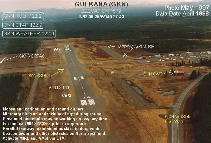
Gulkana Airport in Unorganized Borough is an airfield (IATA: GKN, ICAO: PAGK). Gulkana Airport is also known as GKN. Ⓦ.
- Operator
- State of Alaska DOT&PF
Image
Streets nearby
Gulkana Airport Access Road0.7 mi
Dry Creek State Rec Site Road1.0 mi
Glenn Xing Mp 684.53.0 mi
Richardson HighwayFood For Thought, Donnelly, Pipeline Viewpoint, Richardson Hwy Mile 238, Richardson Hwy Mile 237, Tazlina Liquors, Mile 100 Richardson Highway, Big Delta, Mile 60 Richardson Highway, Denali's Fault. Scenic overlook, Ptarmigan, Worthington Glacier Viewpoint, Welcome to Valdez, Richardson Monument, Thompson Pass Viewpoint
3.2 mi
Glenn Hwy Xing Mp 684.53.5 mi
4 W D Trail3.6 mi
4th Street3.6 mi
3rd Street3.7 mi
2nd StreetMentasta Lake
3.9 mi
1st Street3.9 mi
College Road4.0 mi
Terrace Drive4.0 mi
School Access Road4.1 mi
Aurora DriveAmerican Legion Glennallen
4.3 mi
Birch Street4.3 mi
Co-Op RoadLancasters Backpacker Hostel
4.3 mi
K C A M Radio Station Road4.3 mi
Blackburn Court4.3 mi
Glenn HighwayGlennallen, First National Bank Alaska, U-Haul, Glenn Hwy Xing Mp 684.5, Spruce Burl Espresso and Crepery, Glennallen's Rustic Resort, Subway, Nelchina, Grizzly Country Groceries, Tazlina
4.4 mi
Blackburn Drive4.4 mi
Drum Drive4.4 mi
Chevron DrivewayGlennallen Fuel and Auto Service, Glennallen Towing and Recovery
4.5 mi
Mount Sanford Drive4.5 mi
Cross Road Medical CenterCross Road Medical Center
4.5 mi
Bureau of Land Management Driveway4.6 mi
Crown Drive4.7 mi
B L M Housing Access Road4.7 mi
Pilcho Drive5.0 mi
Amenities nearby
EGN Automotive1.8 mi
Auto parts stores nearby
NAPA4.6 mi
Banks nearby
Wells Fargo4.3 mi
Buildings nearby
Kunick Machine Works2.3 mi
USPS Post Office4.3 mi
Campgrounds nearby
Dry Creek State Recreation Site1.0 mi
Commercial buildings nearby
Copper Valley Telecom3.7 mi
Convenience stores nearby
Hub of Alaska3.5 mi
Sparks General Store3.7 mi
Gas stations nearby
Marathon3.5 mi
Hotels nearby
Caribou Hotel4.6 mi
Industrial areas nearby
Trans-Alaska Pipeline Pump Station 115.0 mi
Industrial buildings nearby
Glenallen Diesel Plant4.3 mi
Liquor stores nearby
Bush Bottle Bin1.9 mi
Office buildings nearby
U.S. Bureau of Land Management, Glennallen Field Office4.6 mi
Restaurants nearby
Tok Thai Food3.5 mi
Rivers nearby
Copper River4.4 mi
Streams nearby
Moose Creek4.7 mi
Studios nearby
KCAM 7904.4 mi
Supermarkets nearby
Copper Valley IGA4.3 mi
Other nearby
Copperville5.1 mi
| Named after | Gulkana |
|---|---|
| Elevation | 1586 |
| Located in | Alaska |
| Country | United States |
 Public transit map Unorganized Borough Legend
| Railway | |
| Bus | |
| Streetcar |
 Bicycle map Unorganized Borough Legend
| Bike path | |
| Bike lane on roadway | |
| Cycling allowed on bus lane | |
| Bicycle street | |
| Open to cyclists | |
| Open to cyclists, good path | |
| Cycling prohibited | |
| Cobblestone |
| Long-distance bike route | (depending on scale) | |
| Long-distance bike route |
 Pedestrian map Unorganized Borough Legend
| Path |
| Long-distance hiking trail | (depending on scale) | |
| Long-distance hiking trail | ||
| Pedestrians prohibited |