
Colorado

Colorado
This City map of Colorado shows the state’s streets, paths, and places across an area of approximately 269,837 square kilometres in the United States. Colorado had 5,773,714 residents in 2020, compared with 5,029,196 in 2010. The state was established in 1876 and reaches a recorded regional elevation of 2,073 metres above sea level. Its landscape includes the Rocky Mountains, the Colorado River, the South Platte River, and the eastern Great Plains.
Central City

Central City is a home rule municipality in Gilpin and Clear Creek counties, Colorado. The settlement was established in 1859 and has a population of 779. At an elevation of 2,594 metres, Central City lies in the Rocky Mountains west of Denver.
To the mapLongmont

Longmont is a city in Boulder County with 98,885 residents and an elevation of 1,519 metres. The city was established in 1871 and covers approximately 74,979,500 square metres. Longmont lies north of Boulder along the St. Vrain Creek, between the Rocky Mountain foothills and the Front Range urban corridor.
To the mapWindsor

Windsor is a town in Larimer and Weld counties, established in 1882. It has 32,716 residents and covers approximately 38,700,000 square metres at an elevation of 1,641 metres. Windsor lies in northern Colorado near the Cache la Poudre River and the cities of Fort Collins and Greeley.
To the mapLochbuie

Lochbuie is a town in Weld County with 8,088 residents. It covers approximately 9,691,883 square metres and stands at an elevation of 1,530 metres. The town is located on Colorado’s northeastern metropolitan fringe, east of the Denver urban area and south of Greeley.
To the mapJackson County

Jackson County covers approximately 4,198 square kilometres in north-central Colorado and had 1,379 residents. The county was established in 1909 and includes the North Park basin. The North Platte River and the surrounding Medicine Bow and Never Summer mountain ranges define major parts of its landscape.
To the mapRoutt County

Routt County was established in 1877 and covers approximately 6,133 square kilometres. It had 24,829 residents and includes Steamboat Springs in the northern Rocky Mountains. The Yampa River crosses the county, while the Routt National Forest occupies extensive mountain terrain.
To the mapProwers County

Prowers County was established in 1889 and covers approximately 4,259 square kilometres in southeastern Colorado. The county had 11,999 residents. Lamar is the principal city, and the Arkansas River runs through the county’s agricultural plains.
To the mapBaca County

Baca County covers approximately 6,623 square kilometres in the southeastern corner of Colorado and had 3,506 residents. It was established in 1889. The county lies on the High Plains near the borders with Kansas and Oklahoma, with the Comanche National Grassland extending across parts of the region.
To the mapBent County

Bent County is located in southeastern Colorado along the Arkansas River. The county seat is Las Animas, and the river valley contains irrigated agricultural land. Bent County lies west of Prowers County and north of the Colorado–New Mexico border region.
To the mapLas Animas County

Las Animas County was established in 1866 and covers approximately 12,368 square kilometres, making it one of Colorado’s largest counties by area. It had 14,555 residents. Trinidad is the county seat, and the county includes the Purgatoire River valley, the Spanish Peaks, and sections of the Raton Basin.
To the mapLa Plata County

La Plata County was established in 1874 and covers approximately 4,403 square kilometres. It had 55,638 residents, with Durango as the principal city. The Animas River flows through Durango, and the county reaches the San Juan Mountains in southwestern Colorado.
To the mapMontezuma County

Montezuma County was established in 1889 and covers approximately 5,284 square kilometres. It had 25,849 residents, and Cortez is the county seat. Mesa Verde National Park lies in the county and contains the UNESCO World Heritage site of the cliff dwellings of Ancestral Puebloan communities.
To the mapDolores County

Dolores County was established in 1881 and covers approximately 2,766 square kilometres. It had 2,326 residents, with Dove Creek and Rico among its known communities. The county includes parts of the San Juan Mountains and the Dolores River watershed in southwestern Colorado.
To the mapSan Juan County

San Juan County is a small, mountainous county in southwestern Colorado, centered on Silverton. It includes steep terrain in the San Juan Mountains and reaches elevations above 4,000 metres. The Animas River begins in the county and flows north toward Durango.
To the mapGunnison County

Gunnison County was established in 1877 and covers approximately 8,443 square kilometres. It had 16,918 residents, with Gunnison and Crested Butte as principal communities. The Gunnison River and the Black Canyon of the Gunnison are major geographic features of the county.
To the mapChaffee County

Chaffee County lies in central Colorado and had 18,658 residents. Salida and Buena Vista are its principal communities, located along the Arkansas River. The county includes the Collegiate Peaks, with several summits exceeding 4,000 metres.
To the mapPitkin County

Pitkin County was established in 1881 and covers approximately 2,521 square kilometres. It had 17,358 residents, and Aspen is the county seat. The Roaring Fork River runs through the county, which extends into the Elk Mountains and includes Maroon Bells.
To the mapKiowa County

Kiowa County is located on Colorado’s southeastern plains, with Eads as its county seat. The county lies in the Arkansas River basin and contains broad grassland and agricultural areas. Its landscape is part of the High Plains east of the Rocky Mountains.
To the mapCostilla County

Costilla County was established in 1861 and covers approximately 3,187 square kilometres. It had 3,499 residents and includes San Luis, the oldest continuously inhabited incorporated community in Colorado, founded in 1851. The county lies in the San Luis Valley near the Sangre de Cristo Mountains.
To the mapMontrose County

Montrose County was established in 1883 and covers approximately 5,808 square kilometres. It had 42,679 residents, with the city of Montrose as its main population centre. The Uncompahgre River passes through the county, and Black Canyon of the Gunnison National Park begins to the northeast.
To the mapPark County

Park County lies southwest of Denver and had 16,510 residents. Fairplay is the county seat, located in the broad South Park basin. The county contains portions of the Mosquito Range and the headwaters of the South Platte River.
To the mapSummit County

Summit County was established in 1861 and covers approximately 1,604 square kilometres. It had 31,055 residents and includes Breckenridge, Frisco, Silverthorne, and Dillon. The county occupies a high Rocky Mountain basin near the Continental Divide, with the Blue River flowing through it.
To the mapClear Creek County

Clear Creek County was established in 1861 and covers approximately 1,027 square kilometres. It had 9,397 residents, and Georgetown and Idaho Springs are historic communities along Clear Creek. Interstate 70 crosses the county toward the Continental Divide at Berthoud Pass and Loveland Pass.
To the mapHinsdale County

Hinsdale County was established in 1874 and covers approximately 2,909 square kilometres. It had 788 residents, making it one of Colorado’s least populated counties. Lake City is the county seat, and the county includes the Lake San Cristobal basin and remote sections of the San Juan Mountains.
To the mapMineral County

Mineral County was established in 1893 and covers approximately 2,273 square kilometres. It had 865 residents, with Creede as the county seat. The county follows the upper Rio Grande valley and includes mountain terrain in the San Juan Mountains.
To the mapSaguache County

Saguache County was established in 1866 and covers approximately 8,206 square kilometres. It had 6,368 residents and includes the towns of Saguache, Center, and Crestone. The county spans the San Luis Valley, the Sangre de Cristo Mountains, and the upper Rio Grande watershed.
To the mapKit Carson County

Kit Carson County was established in 1889 and covers approximately 5,598 square kilometres. It had 7,087 residents, with Burlington as the county seat. The county occupies Colorado’s eastern plains near the Kansas border, and the Republican River basin crosses its northern area.
To the mapMoffat County

Moffat County was established in 1911 and covers approximately 12,305 square kilometres. It had 13,292 residents, with Craig as the county seat. The county includes the Yampa River valley, Dinosaur National Monument to the northwest, and extensive high-desert plateaus.
To the mapArchuleta County

Archuleta County was established in 1885 and covers approximately 3,511 square kilometres. It had 13,359 residents, and Pagosa Springs is the county seat. The San Juan River and the San Juan Mountains define major parts of the county in southwestern Colorado.
To the mapHuerfano County

Huerfano County was established in 1861 and covers approximately 4,126 square kilometres. It had 6,820 residents, with Walsenburg as the county seat. The county contains the Huerfano River valley and the distinctive volcanic landmark of the Spanish Peaks.
To the mapWashington County

Washington County is located on Colorado’s northeastern plains, with Akron as its county seat. The county lies within the South Platte River basin and contains broad agricultural landscapes. Its eastern boundary approaches the Nebraska state line.
To the mapElbert County

Elbert County was established in 1874 and covers approximately 4,794 square kilometres. It had 26,062 residents, with Kiowa as the county seat. The county lies southeast of Denver on the eastern slope of the Front Range, including rolling plains and the headwaters of Cherry Creek.
To the mapCrowley County

Crowley County is located in southeastern Colorado along the Arkansas River. Ordway is the county seat, and irrigated farmland occupies parts of the river valley. The county lies between Pueblo County and Kiowa County on the eastern plains.
To the mapBroomfield

Broomfield is a consolidated city-county established in 2001, with 74,112 residents. It covers approximately 86,890,278 square metres and stands at an elevation of 1,629 metres. The municipality lies between Denver and Boulder along the U.S. 36 corridor and is one of Colorado’s 64 counties.
To the mapPhillips County

Phillips County is located in northeastern Colorado, with Holyoke as its county seat. The county lies in the Republican River basin near the Nebraska border. Agriculture and the river valley define the settled areas of this eastern plains county.
To the mapLarimer County

Larimer County was established in 1861 and covers approximately 6,822 square kilometres. It had 359,066 residents, with Fort Collins and Loveland among its principal cities. The county extends from the Cache la Poudre River valley into Rocky Mountain National Park and the Front Range.
To the mapMorgan County

Morgan County was established in 1889 and covers approximately 3,351 square kilometres. It had 29,111 residents, with Fort Morgan as the county seat. The South Platte River crosses the county, supporting agricultural settlements on Colorado’s northeastern plains.
To the mapRio Grande County

Rio Grande County was established in 1874 and covers approximately 2,362 square kilometres. It had 11,539 residents, with Del Norte and Monte Vista among its main communities. The Rio Grande flows through the San Luis Valley, which is bordered by the San Juan and Sangre de Cristo mountains.
To the mapCheyenne County

Cheyenne County is located in southeastern Colorado, with Cheyenne Wells as its county seat. The county lies on the High Plains near the Kansas border. Its drainage belongs to the Arkansas River basin, and the landscape is dominated by open grassland and agricultural land.
To the mapJefferson County

Jefferson County was established in 1861 and covers approximately 2,015 square kilometres. It had 582,910 residents and includes Lakewood, Arvada, Golden, and other western Denver suburbs. The county extends from the metropolitan plain into the foothills, with Clear Creek passing through Golden.
To the mapPueblo County

Pueblo County was established in 1874 and covers approximately 6,210 square kilometres. It had 168,162 residents, with Pueblo as the county seat and largest city. The Arkansas River crosses the county, which lies between the Front Range and the southeastern Colorado plains.
To the mapLake County

Lake County was established in 1861 and covers approximately 994 square kilometres. It had 7,436 residents, with Leadville as the county seat. The county contains Mount Elbert, Colorado’s highest mountain at 4,401 metres, and the upper Arkansas River valley.
To the mapLincoln County

Lincoln County was established in 1889 and covers approximately 6,699 square kilometres. It had 5,675 residents, with Limon as the county seat. The county lies on the eastern plains between the South Platte and Arkansas river basins and is crossed by major east–west transport routes.
To the mapTeller County

Teller County lies west of Colorado Springs and had 23,385 residents. Cripple Creek and Woodland Park are its best-known communities, connected with the region’s historic gold-mining period. The county occupies forested foothills and mountain terrain on the eastern side of the Pikes Peak massif.
To the mapRio Blanco County

Rio Blanco County was established in 1889 and covers approximately 8,347 square kilometres. It had 6,529 residents, with Meeker as the county seat. The county includes the White River valley, the Flat Tops, and high-desert terrain in northwestern Colorado.
To the mapGilpin County

Gilpin County was established in 1861 and covers approximately 389 square kilometres. It had 5,808 residents, with Central City and Black Hawk among its historic communities. The county lies in the Front Range west of Denver and includes mountain valleys associated with Colorado’s nineteenth-century gold rush.
To the mapWeld County
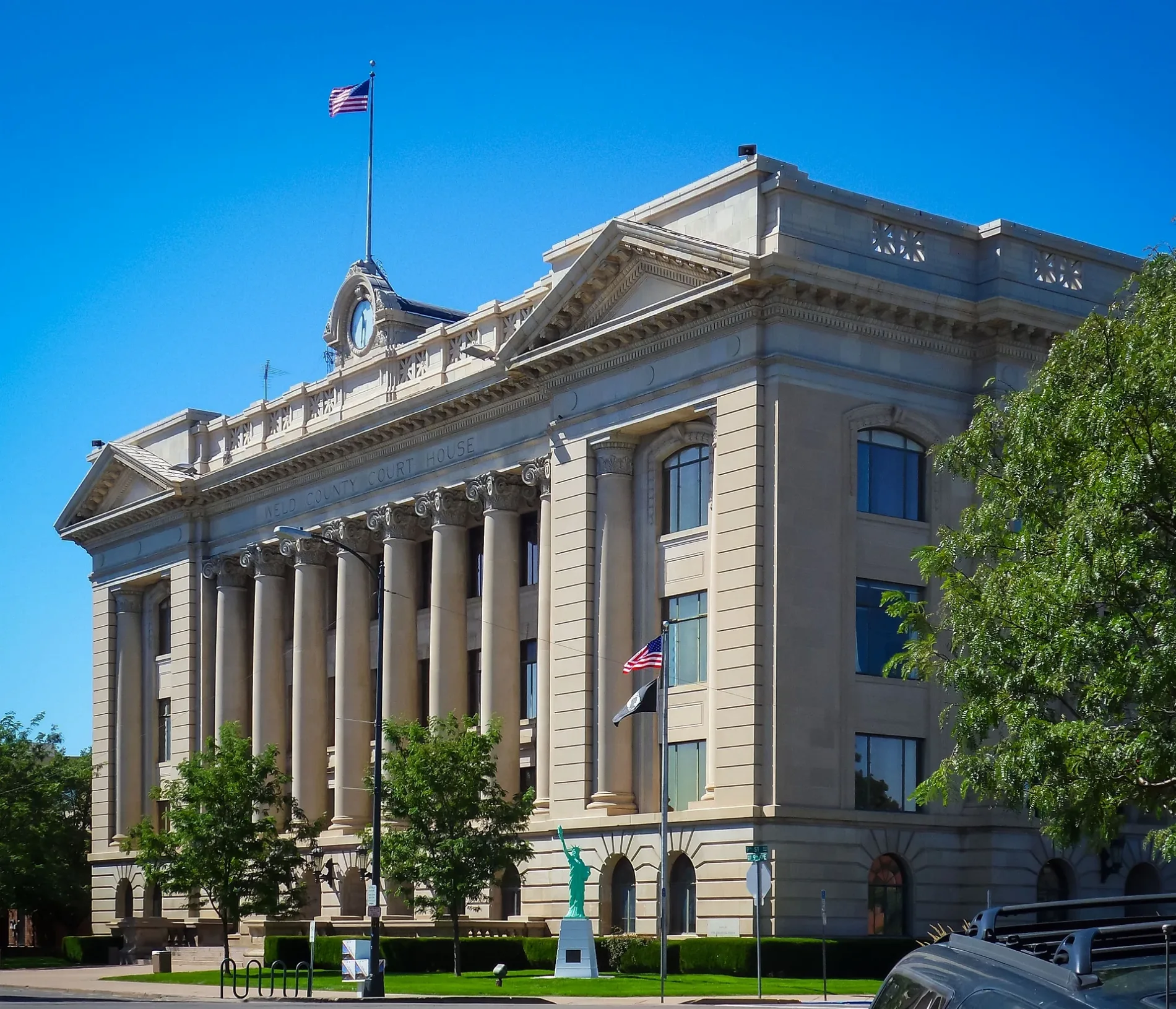
Weld County was established in 1861 and covers approximately 10,416 square kilometres. It had 328,981 residents, with Greeley as the county seat and largest city. The county occupies the northern Front Range and eastern plains, where the South Platte and Cache la Poudre rivers support extensive agriculture.
To the mapEl Paso County

El Paso County is centered on Colorado Springs and had 674,471 residents. The county includes the eastern face of Pikes Peak, which rises to 4,302 metres, and the Arkansas River basin. Colorado Springs is the county seat and the second-largest city in Colorado by population.
To the mapYuma County

Yuma County was established in 1889 and covers approximately 6,136 square kilometres. It had 9,988 residents, with the city of Yuma as the county seat. The county lies in northeastern Colorado along the Republican River and the agricultural High Plains.
To the mapBoulder County

Boulder County was established in 1861 and covers approximately 1,946 square kilometres. It had 330,758 residents and includes Boulder, Longmont, and Louisville. The county stretches from the plains to the Flatirons and the Front Range, with Boulder Creek flowing through the city of Boulder.
To the mapDouglas County

Douglas County was established in 1861 and covers approximately 2,183 square kilometres. It had 357,978 residents, with Castle Rock as the county seat and Highlands Ranch as a major suburban community. The county lies between Denver and Colorado Springs along the Front Range, with the South Platte River forming part of its western area.
To the mapDenver
Denver is Colorado’s capital and a consolidated city-county established in 1858. It had 715,522 residents, covers approximately 401,359,761 square metres, and stands at an elevation of 1,609 metres. The city lies at the South Platte River and Cherry Creek, east of the Rocky Mountain foothills.
To the mapGarfield County

Garfield County was established in 1883 and covers approximately 7,655 square kilometres. It had 61,685 residents, with Glenwood Springs, Rifle, and Carbondale among its principal communities. The Colorado River and the Roaring Fork River meet near Glenwood Springs, while the county extends into the Elk and White River mountains.
To the mapMesa County

Mesa County was established in 1883 and covers approximately 8,653 square kilometres. It had 155,703 residents, with Grand Junction as the county seat and largest city. The Colorado River runs through the Grand Valley, and Colorado National Monument forms a major group of sandstone canyons west of Grand Junction.
To the mapConejos County

Conejos County was established in 1861 and covers approximately 3,343 square kilometres. It had 7,461 residents, with Conejos and Alamosa-area communities in the San Luis Valley. The Rio Grande and Conejos River drain the county, which reaches the San Juan Mountains to the west.
To the mapOtero County

Otero County was established in 1889 and covers approximately 3,289 square kilometres. It had 18,690 residents, with La Junta as the county seat. The Arkansas River passes through the county, and Bent’s Old Fort National Historic Site preserves a nineteenth-century trading post near the river corridor.
To the mapLogan County
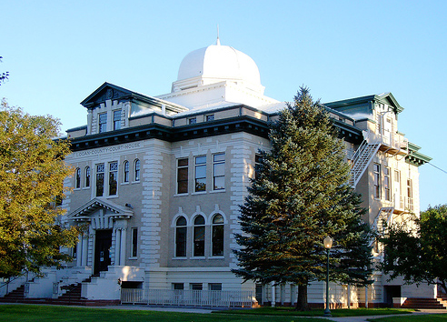
Logan County was established in 1887 and covers approximately 4,778 square kilometres. It had 21,528 residents, with Sterling as the county seat. The South Platte River crosses the county, whose eastern plains support irrigated farming and communities connected by U.S. Highway 6 and Interstate 76.
To the mapOuray County

Ouray County was established in 1877 and covers approximately 1,405 square kilometres. It had 4,874 residents, with Ouray and Ridgway as principal communities. The county lies in the San Juan Mountains, and the Uncompahgre River runs through the Ouray valley.
To the mapAdams County

Adams County was established in 1901 and covers approximately 3,102 square kilometres. It had 519,572 residents and includes Thornton, Commerce City, Brighton, and Northglenn. The county forms part of the Denver metropolitan area north of the city, with the South Platte River crossing its western section.
To the mapCuster County

Custer County was established in 1877 and covers approximately 1,916 square kilometres. It had 4,704 residents, with Westcliffe and Silver Cliff as its principal communities. The county lies in the Wet Mountains west of the Huerfano and Arkansas river valleys and includes the eastern approach to the Sangre de Cristo Range.
To the mapData sources: OpenStreetMap (ODbL), Wikidata (CC0) · Image: Wikimedia Commons
| Named after | Colorado River |
|---|---|
| Year built | 1876 |
| Area | 269837 km² |
| Elevation | 2073 m |
| Located in | United States |
| Country | United States |
| Body of water | Colorado River, Arkansas River, South Platte River |
| Population | 5773714 |
| Nickname | The Centennial State |
| Native name | Colorado |
| Official name | State of Colorado |

 Public transit map Colorado Legend
 | Railway | |
| Bus | |
| Tram |
 Bicycle map Colorado Legend
 | Bike path | |
| Bike lane on roadway | |
| Cycling allowed on bus lane | |
| Bicycle street | |
| Open to cyclists | |
| Open to cyclists, good path | |
| Cycling prohibited | |
| Cobblestone |
| Long-distance bike route | (depending on scale) | |
| Long-distance bike route |
 Pedestrian map Colorado Legend
 | Path |
| Long-distance hiking trail | (depending on scale) | |
| Long-distance hiking trail | ||
| Pedestrians prohibited |