
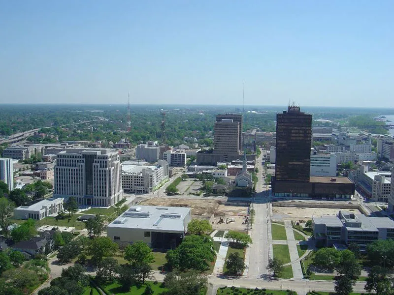
Lafayette Street in Downtown Development District, Baton Rouge, Louisiana
Lafayette Street in Baton Rouge is a single-lane, concrete residential street. It runs as a one-way street in a South direction starting from North 3rd Street and crosses North Street, Main Street, Laurel Street, Florida Street and Convention Street and ends at North Boulevard. Nearby you can find a place of worship and a charging station. The nearest bus stop is LaSalle Building (about 100 m away).
- Road Type
- residential street
- Speed Limit
- 30 mph
- Lanes
- 1
- Route
- north-south
Image
Streets nearby
North 3rd StreetLife Storage, Baton Rouge Junction, First Circuit Court of Appeals Poydras Building, N 3rd @ North Campus, Claiborne Building, LaSalle Building, Capitol Building
450 ft
North Street500 ft
Main StreetGreen Park
0.1 mi
Spanish Town Road0.2 mi
North River RoadPentagon Barracks Museum, Sing The River, River Road @ Hollywood Casino
0.2 mi
North 5th StreetSaint James Episcopal Day School, Main Street Market
0.2 mi
3rd Street300 Block Third Street, 400 Block of Third Street, The Little Village, 13 Social, Demi Nola Blends Smoothie & Juice Bar, 200 Block of Third Street, Somewhere Neighborhood Bar 214
0.2 mi
Florida StreetFlixBus Baton Rouge, The Way of Holiness Church, Greyhound Shop, Exxon, Baton Rouge, Rivermark Centre
0.3 mi
University Walk0.3 mi
Laurel Street0.3 mi
Convention StreetSaint James Episcopal Day School, La Mission Bautista Hispana De La Primera Iglesia, Downtown, LSU Museum of Art, The Gregory
0.4 mi
North 4th StreetState Museum, 4th & Main Streets, 4th St @ Laurel St, 4th & Florida Streets
0.4 mi
North 6th Street0.4 mi
Auto repair shops nearby
Firestone0.4 mi
Banks nearby
Bank Plus0.4 mi
Bars nearby
The Main Lobby0.4 mi
Happy's Irish Pub0.4 mi
Jolie Pearl Oyster Bar0.4 mi
Buildings nearby
LaSalle Building100 ft
Iberville Building450 ft
Kress Building0.2 mi
Bienville Building0.2 mi
Fuqua Hardware Store Building0.2 mi
Belisle Building0.2 mi
Galvez Building0.3 mi
Central Fire Station0.3 mi
Helix Steam Mentorship Academy0.3 mi
Capitol City Press Building0.3 mi
Baton Rouge City Club0.4 mi
Commercial buildings nearby
Knox Building0.2 mi
Gardens nearby
Huey P Long Garden0.2 mi
Hotels nearby
Hampton Inn & Suites Baton Rouge Downtown0.1 mi
Courtyard Baton Rouge Downtown0.3 mi
Hotel Indigo Baton Rouge Downtown0.3 mi
WATERMARK Baton Rouge, Autograph Collection0.4 mi
Houses nearby
Florence Coffee House0.2 mi
Industrial buildings nearby
Central Plant South50 ft
Libraries nearby
Louisiana State Library0.1 mi
Museums nearby
Capitol Park Museum0.2 mi
Office buildings nearby
One American Place0.2 mi
Parking lots nearby
State Welcome Center Parking Garage300 ft
LaSalle Garage0.1 mi
Galvez Garage0.3 mi
Parks nearby
A. Z. Young Park250 ft
Places of worship nearby
Saint Joseph Cathedral0.2 mi
Saint James Episcopal Church0.4 mi
First Baptist Church0.4 mi
Other nearby
Spanish Town0.3 mi
Downtown Baton Rouge0.3 mi
Public transit map Downtown Development District Legend
| Railway | |
| Bus | |
| Streetcar |
Bicycle map Downtown Development District Legend
| Bike path | |
| Bike lane on roadway | |
| Cycling allowed on bus lane | |
| Bicycle street | |
| Open to cyclists | |
| Open to cyclists, good path | |
| Cycling prohibited | |
| Cobblestone |
| Long-distance bike route | (depending on scale) | |
| Long-distance bike route |
Pedestrian map Downtown Development District Legend
| Path |
| Long-distance hiking trail | (depending on scale) | |
| Long-distance hiking trail | ||
| Pedestrians prohibited |