
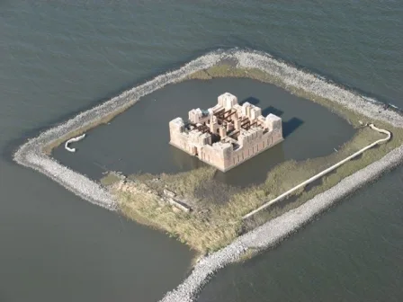
Fort Proctor in St. Bernard Parish, Louisiana
Fort Proctor in Saint Bernard Parish is a fort (built in 1856). Fort Proctor is located near Canary Island Key. Ⓦ.
- Building Type
- building
Image
Gas stations
Post offices
Pharmacies
Supermarkets
Schools
Fast food restaurants
Vending machines
Places of worship
Kindergartens
Cemeteries
Campgrounds
Payment terminals
Streets nearby
Canary Island Key0.9 mi
Black Beard Key1.0 mi
Islenos Key1.1 mi
West Indies Drive1.1 mi
Alluvial Key1.1 mi
Bench Boulevard1.1 mi
3rd Street1.2 mi
Caribbean Key1.2 mi
Joy Boulevard1.2 mi
2nd Street1.3 mi
Yscloskey HighwayShell Beach, Yscloskey
1.5 mi
Fr Beauregard Boulevard1.6 mi
Ft Beauregard Boulevard1.7 mi
Chevron Plant Road1.8 mi
Robin Street1.8 mi
Couture Road1.8 mi
Maple Street1.8 mi
Latapie Lane1.8 mi
Bruce Lane1.9 mi
Sophie Lane1.9 mi
Citrus Avenue1.9 mi
Florissant HighwayAlluvial City
2.1 mi
South Pumping Station Road3.3 mi
Eagle Road3.4 mi
North Pumping Station Road3.5 mi
Roselyn Road4.4 mi
Goat Avenue5.2 mi
Head Lane5.2 mi
Louisiana Highway 465.2 mi
Hopedale HighwayHopedale
5.2 mi
Bayou RoadVerret, Kenilworth, Contreras, Sebastopol, Toca, Saint Bernard, Creedmore Church
5.4 mi
Lewisch Lane5.6 mi
Buildings nearby
Melerine Seafood (Annex)4.0 mi
Canals nearby
Mississippi River-Gulf Outlet4.2 mi
Mobile homes nearby
Cajun Saint Lodge4.1 mi
Streams nearby
Bayou la Loutre1.9 mi
| Heritage designation | National Register of Historic Places listed place |
|---|---|
| Located in | St. Bernard Parish |
| Country | United States |
| Described by | FortWiki |
 Public transit map Saint Bernard Parish Legend
| Railway | |
| Bus | |
| Streetcar |
 Bicycle map Saint Bernard Parish Legend
| Bike path | |
| Bike lane on roadway | |
| Cycling allowed on bus lane | |
| Bicycle street | |
| Open to cyclists | |
| Open to cyclists, good path | |
| Cycling prohibited | |
| Cobblestone |
| Long-distance bike route | (depending on scale) | |
| Long-distance bike route |
 Pedestrian map Saint Bernard Parish Legend
| Path |
| Long-distance hiking trail | (depending on scale) | |
| Long-distance hiking trail | ||
| Pedestrians prohibited |