
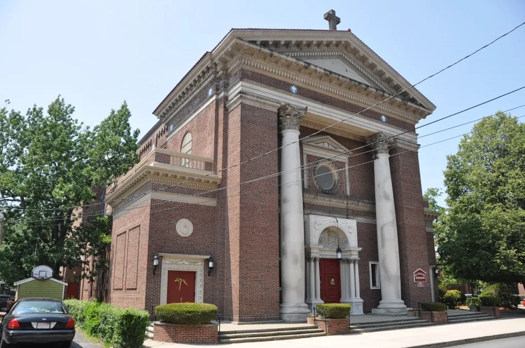
Saint Charles Borromeo Catholic Church in Waltham, Massachusetts
Saint Charles Borromeo Catholic Church in Waltham is a Catholica Church, Hall Street 51. It is built in the Renaissance Revival architecture style and was built in 1915. The Church is a protected historic site. Ⓦ.
- House Number
- 51
- Street
- Hall Street
- Amenity
- place of worship
- Building Type
- building
Image
Bars
Gift shops
Bakeries
Laundries
Convenience stores
Restaurants
Bus stops
Beauty salons
Hair salons
Ice cream shops
Streets nearby
Standish Court150 ft
Cushing StreetSolea
200 ft
Chestnut Avenue250 ft
Lowell Street350 ft
Hall Street400 ft
Moody StreetMoody St @ Cushing St, Moody St @ Walnut St, Deep Ellum, Lizzy's Ice Cream Parlor, The Tea Leaf, A1 Market, Vinotta, Boost Mobile, Driving Lessons with L & M, Nice & Lovely, Henessys Beauty Salon, Little India, Sweet Basil, Los Primos, Pho and Spice, Rose Nails, Sparkle Brite, Jocos Bar and Kitchen, Tempo, Amuleto, Gourmet Pottery, Peppino's Dosa, Moody St @ Main St, Moody St @ Adams Ave, Moody St opp Underwood Pk, Moody St @ High St, Moody St @ Ash St, Moody St @ Robbins St, New Dragon Chef, Athens Pizza, Moody St @ Derby St, Moody St @ Orange St, Moody St @ Washington Ave, Heidi's Restaurant, Shopper's, Franco's Pizzeria & Pub, Moody Spa, Salgueros Market 3, Moody St @ Pine St, Gustazo Cuban Kitchen & Bar, Emma's Macarons, Kung Fu Tea, Moody St @ Carter St, Moody St @ Main St., Penang, Angelo's House of Pizza, Mi Tierra, Gordon's Liquors, Masao's Kitchen, Ponzu Izakaya, Moody St @ Crescent St, The Telephone Museum, Bistro781, Global Thrift, Game Underground - Arcade
0.1 mi
Union Street0.1 mi
Lowell Place0.1 mi
Gardner Street0.1 mi
Alder Street0.1 mi
Maple StreetMoody St @ Maple St, Advanced Waltham Dental, Anojitos Cafe
0.1 mi
Gordon StreetTara Restaurant Pizza & More
0.1 mi
Beech Street0.1 mi
Walnut StreetWalnut Street Lot Charging Station
0.2 mi
Pine StreetBrewer's Tap & Table, Sakura
0.2 mi
Stearns Street0.2 mi
Chestnut StreetLa Castellana, Mr. Sweeper Vacuums
0.2 mi
Cooper Street0.2 mi
Myrtle StreetSouth Side, Salgueros Market, Los Maestros Barber Shop
0.2 mi
Clinton Street0.2 mi
Cutter Street0.2 mi
Newton StreetCasa D'Italia
0.2 mi
Taylor StreetEdible Arrangements
0.2 mi
High StreetHigh St @ Newton St, High St @ Cedar St, High St @ Hamblin Rd, High St @ Hovey Rd, High St @ Pamenter Rd, High St @ Parmenter Rd, High St @ Beech St, High St @ Gardner St, High St @ Hall St, High St @ Moody St
0.2 mi
Gorham Street0.2 mi
Elm Court0.3 mi
Oak Street0.3 mi
Yetten Terrace0.3 mi
Brown Street0.3 mi
Bolton Street0.3 mi
Acorn Street0.3 mi
Robbins Place0.3 mi
Parmenter Road0.4 mi
Robbins Street0.4 mi
Wadsworth Avenue0.4 mi
Ash Street7-Eleven, Dunkin'
0.4 mi
Fuller Street0.4 mi
Buildings nearby
Stark Building450 ft
Waltham Community & Cultural Center0.1 mi
Arthur J. Clark Building0.2 mi
Fire stations nearby
Moody Street Fire Station0.2 mi
Parks nearby
Peter Gilmore Playground350 ft
McDonald Playground0.2 mi
Chemistry Station Park0.3 mi
Places of worship nearby
Beth Eden Baptist Church0.2 mi
Immanuel United Methodist Church0.2 mi
Retail buildings nearby
Global Thrift0.1 mi
Schools nearby
Henry Whittemore Elementary School0.4 mi
Supermarkets nearby
Patel Brothers0.1 mi
| Year built | 1915 |
|---|---|
| Architectural style | Renaissance Revival architecture, Neoclassical architecture |
| Heritage designation | National Register of Historic Places listed place |
| Located in | Waltham |
| Country | United States |
 Public transit map Waltham Legend
| Railway | |
| Bus | |
| Streetcar |
 Bicycle map Waltham Legend
| Bike path | |
| Bike lane on roadway | |
| Cycling allowed on bus lane | |
| Bicycle street | |
| Open to cyclists | |
| Open to cyclists, good path | |
| Cycling prohibited | |
| Cobblestone |
| Long-distance bike route | (depending on scale) | |
| Long-distance bike route |
 Pedestrian map Waltham Legend
| Path |
| Long-distance hiking trail | (depending on scale) | |
| Long-distance hiking trail | ||
| Pedestrians prohibited |