
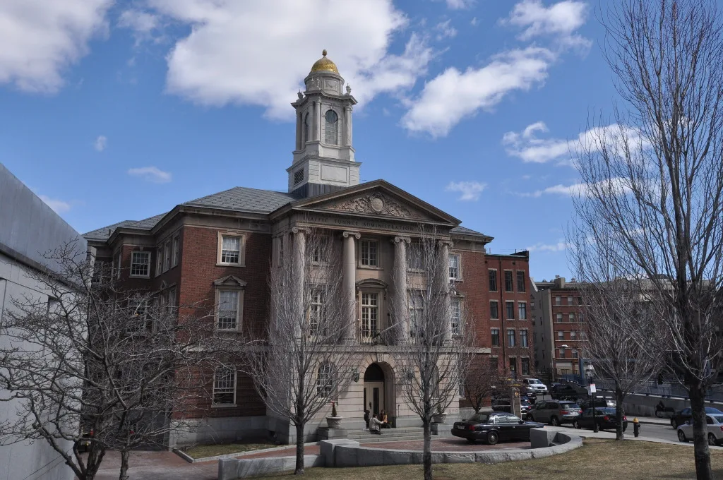
Traffic Tunnel Administration Building in Boston
Traffic Tunnel Administration Building in Boston is a historic building (built in 1931), North Street 128 (02113). Traffic Tunnel Administration Building is built in the Neoclassical architecture style. Ⓦ.
- House Number
- 128
- Postal Code
- 02113
- Street
- North Street
- Building Type
- building
- Website
- https://www.encirclephotos.com/image/traffic-tunnel-administration-building-in-boston-massachusetts/
Image
Banks
Bakeries
Artworks
Liquor stores
Delis
Dentist offices
Restaurants
Cafes
Colleges
Post offices
Pharmacies
ATMs
Tourist information centers
Viewpoints
Streets nearby
North StreetNorth Bennet Street School, Natural Glow, Uvida Shop
150 ft
Callahan TunnelMeridian St @ Havre St
250 ft
Quincy Court350 ft
North SquareGennaro's, Boston Gift Shop, Mamma Maria
400 ft
Bakers AlleyLimoncello
400 ft
Wesley PlaceCharlotte Cushman School, Bella Vista, Caffé Vittoria, Stanza dei Sigari
500 ft
Lathrop PlaceCarmelina's, Citizens Bank
500 ft
Langdon Place0.1 mi
Archway Street0.1 mi
Fulton Street0.1 mi
Public Alley 1010.1 mi
Prince StreetArtu', China House, Sol Optics, Florentine Cafe, Isabella Boston, Caffé dello Sport, Monica‘s, Gaetano Iovanni Square, PFC. Stephen J. Steriti Square, Assaggio, Bova's Bakery, Dino's
0.1 mi
Cross StreetTony DeMarco, Bluebikes
0.1 mi
Garden Court Street0.1 mi
Sun Court StreetSaint John Elementary
0.1 mi
Moon Street0.1 mi
Richmond StreetMonsignor Ryan Memorial High School Library, Rockland Trust, Lower Mills Branch Library, Cirace's & Son, Salumeria Italiana, Vinoteca di Monica, Eastern Bank, Monica's Pasta Shop, Giangrasso Dental
0.1 mi
Lewis StreetCollective Salon, Tenoch Mexican, Piccolo Nido, Prolific Inventor: Otis Tufts, View of Boston in 1848, "Extraordinary Passage of the Flying Cloud", Crossing the Harbor, The Smoke Shop BBQ
0.2 mi
Webster Place0.2 mi
Atlantic AvenueAtlantic Ave @ Commercial Wharf, Urban AdvenTours, Urban Cycles, Atlantic Ave @ Congress St, Denise Hajjar, Atlantic Ave @ Atlantic Ave, Atlantic Ave @ Rowes Wharf, Atlantic Ave @ Seaport Blvd., James Hook & Co., Atlantic Ave @ State St-Marriot Hotel, Trolley, Tia's, Atlantic Ave @ Milk St
0.2 mi
Fleet StreetBlessimo, Sunny Girl, Hanover Wine & Spirit
0.2 mi
Mercantile Street0.2 mi
Commercial Wharf WestGolden Goose Market
0.2 mi
Commercial Wharf EastThe Daily Catch
0.2 mi
Walsh Place0.2 mi
Commercial WharfBoston Sail Loft
0.2 mi
Lewis Wharf0.2 mi
John F. Fitzgerald Surface RoadBluebikes, Pita, Surface Rd @ Hanover St, Chinatown Gate, Haymarket Square, Atlantic Ave @ Central St
0.2 mi
Clark Street0.2 mi
Eastern AvenueStarbucks
0.2 mi
Artworks nearby
Labyrinth0.2 mi
Attractions nearby
Greenway Carousel0.2 mi
Buildings nearby
Ausonia Apartments0.2 mi
Christopher Columbus Plaza0.2 mi
Sumner Tunnel Vent Building0.2 mi
Granite Building0.2 mi
The Pilot House0.2 mi
Clinics nearby
North End Rehabilitation and Healthcare Center400 ft
Gardens nearby
Saint Leonard's Peace Garden0.1 mi
Rose Kennedy Rose Garden0.2 mi
Museums nearby
Paul Revere House500 ft
Parks nearby
Richmond & North Streets Park300 ft
Rachel Revere Park450 ft
Armenian Heritage Park0.2 mi
Christopher Columbus Waterfront Park0.2 mi
Places of worship nearby
Sacred Heart Catholic Church0.1 mi
Retail buildings nearby
Mercantile Hall0.1 mi
Service buildings nearby
Callahan Tunnel Vent Building400 ft
Tourist information centers nearby
Boston Harbor Islands Welcome Center0.2 mi
| Architectural style | Neoclassical architecture |
|---|---|
| Heritage designation | National Register of Historic Places listed place |
| Located in | Boston |
| Country | United States |
 Public transit map Boston Legend
| Railway | |
| Bus | |
| Streetcar |
 Bicycle map Boston Legend
| Bike path | |
| Bike lane on roadway | |
| Cycling allowed on bus lane | |
| Bicycle street | |
| Open to cyclists | |
| Open to cyclists, good path | |
| Cycling prohibited | |
| Cobblestone |
| Long-distance bike route | (depending on scale) | |
| Long-distance bike route |
 Pedestrian map Boston Legend
| Path |
| Long-distance hiking trail | (depending on scale) | |
| Long-distance hiking trail | ||
| Pedestrians prohibited |