
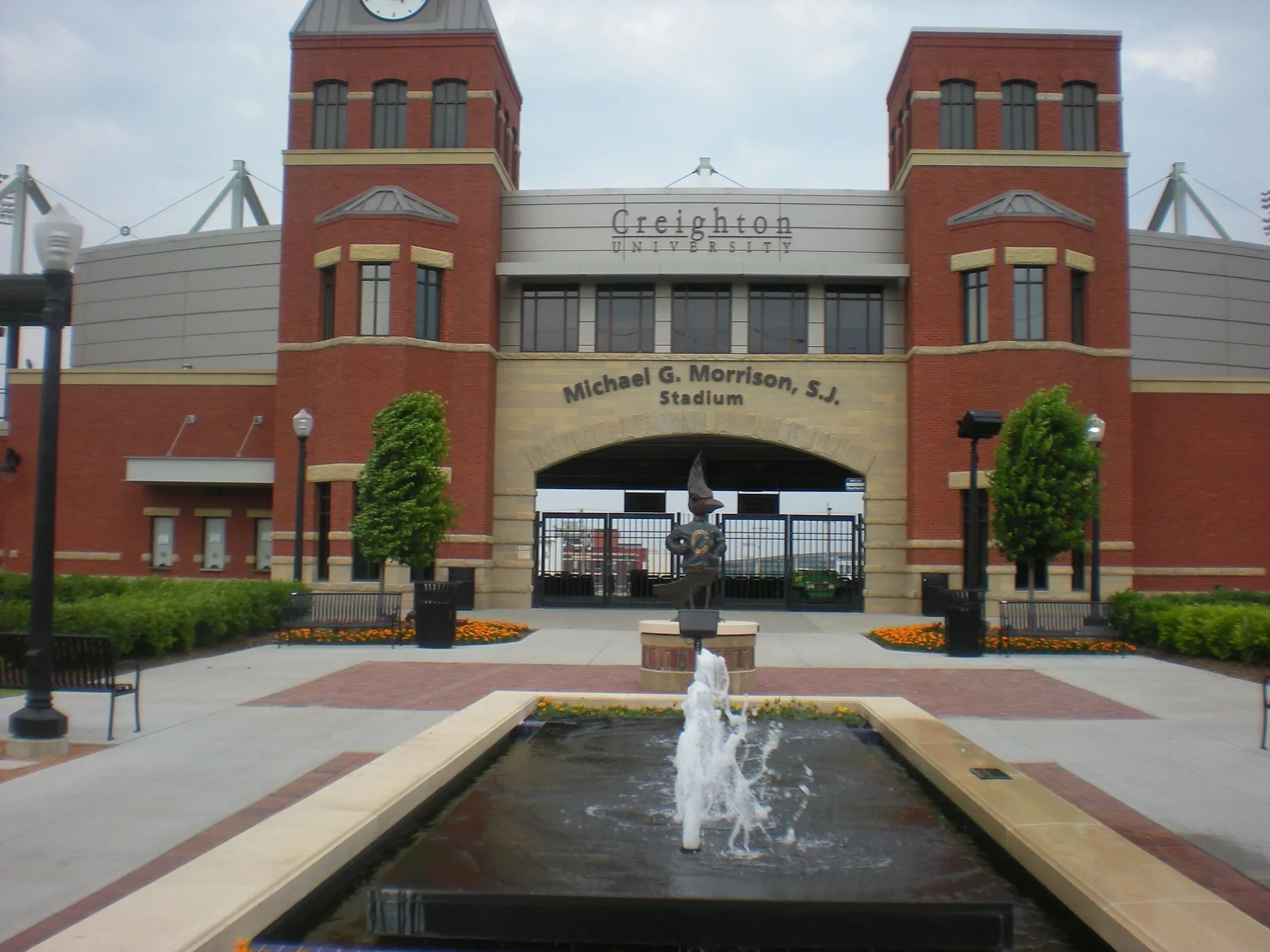
Morrison Stadium in Omaha, Nebraska
Morrison Stadium in Omaha is a sports field (Soccer). Morrison Stadium is also known as Creighton University soccer stadium. Morrison Stadium is located near Florence Boulevard. Ⓦ.
- Leisure
- sports field
Image
Restaurants
Pubs
Nightclubs
Bicycle parking
Bus stops
Artworks
Libraries
Platforms
Clothing stores
Bars
Kindergartens
Movie theaters
Sporting goods stores
Places of worship
Cafes
Streets nearby
Cass StreetA V Sorenson Branch Library, Lewis Art Gallery, Personal Threads Boutique, Lied Education Center for the Arts, Fazoli's
300 ft
North 16th StreetN 16th St & Mike Fahey St (NW), N 16th St & Mike Fahey St (SE), 16th and Davenport, Saint John Baptist Church
0.2 mi
California StreetMidwest Allergy and Asthma Clinic, Physicians Clinic, California Taco
0.2 mi
Burt StreetBaxter Subaru, Saint Cecilia Cathedral, Duchesne Academy Historical Marker, Apostolic Life Center, Baxter Volkswagen Omaha, Audi Omaha, Burt St & N 90th St, Extended Stay America - Omaha - West
0.2 mi
Chicago Street0.2 mi
North 15th Street0.2 mi
North 19th Street0.2 mi
Mike Fahey StreetLawlor's Custom Sportswear, Ruth Sokolof Theater, NoDo, Rocco's Pizza & Cantina, Lefty's, Mike Fahey St & N 16th St (SW), Mike Fahey St & N 15th St (SW)
0.2 mi
North 17th Street0.2 mi
Gerald R Ford Expressway0.2 mi
Florence Boulevard0.2 mi
Capitol AvenueMoe & Curly's, J. Gilberts, Starbucks, Howard & Fine, DJ's Dugout, Bright Horizons Edward Zorinsky Child Development Center, 16th & Capitol
0.3 mi
Cuming StreetCuming & 30th NW, The Salvation Army Chapel, Harvest Community Church, Village Pointe Toyota, China Taste, IDEAL, 24th & Cuming SW, The Road to Omaha, CL and Rachel Werner Center for Health Sciences Education, 24th & Cuming NW, Subway, The Dugout, Burger Theory, 23rd & Cuming NE, 22nd & Cuming SW
0.3 mi
Izard StreetCalvary Chapel of Omaha, Omaha Memorial Seventh-day Adventist School
0.3 mi
Davenport StreetSaint Barnabas Parish, Yates Alternative School, Society 1854, The Jewell, Burdock + Bitters, Muenster Chiropractic Clinic, 16th and Davenport, Fuzzy's Taco Shop, American Eagle Outfitters, Cold Stone Creamery, Gap, J.Crew, Maurices, Eat Fit Go, Lululemon, V Nails, Kumon, claire's, Bath & Body Works, Carter's, 402 Eat + Drink, Altar'd State, Arula, Warby Parker, Coach, Sunglass Hut, CHI Health Amphitheatre, Rowan, Gunderson's Jewelry, Madewell, Lush, White House Black Market, Old Navy, JoS. A. Bank, Village Pointe East, Christopher & Banks, Loft, Banana Republic, DSW, Apple Store, Sephora, Francesca's, Soma, Evereve, Ancho & Agave, Fabletics, Aerie, Athleta, Tradehome Shoes, Scooter's Coffeehouse, Buckle, Yellow Ascending, 22 1/2 Degrees with Crayon Tips, Annie's, Epoca Cantina, Beer Can Alley, The Exchange, Garbo's Salon & Spa, Chico's, J.Jill, Kendra Scott, Goodly Cookies
0.3 mi
North 21st StreetChurch of the Living God
0.4 mi
North 22nd StreetJesuit Middle School of Omaha, Sacred Heart High School, Paradise Baptist Church
0.4 mi
North 18th StreetSecond Baptist Church, Holy Family Church
0.4 mi
North 20th Street0.4 mi
North 24th Street24th & Cuming SE, Durham Cafe, Folded Square Alphabet O, Pencil Bench, 24th & Lake (NW), 24th & Redick, JnD Grocery, 24th & Chicago SE, 24th & Lake (SE), Goodwin's Spencer Street Barber Shop, True Holiness Church, 24th & Cuming NW, Sinclair, 24th St & Metro Entrance SE, 24th & Chicago NW
0.5 mi
North 23rd Street0.5 mi
Buildings nearby
Ryan Athletics Center and DJ Sokol Arena0.1 mi
Championship Center0.1 mi
Wareham Building0.1 mi
Jelinek Building0.1 mi
Opus Hall0.1 mi
Linn Building0.2 mi
Labaj Building0.2 mi
Ruth Scott Training Center0.2 mi
Murphy Building0.2 mi
Kitty Gaughan Pavilion0.3 mi
McGloin Hall0.3 mi
Commercial buildings nearby
Metro Transit Omaha & MAPA0.4 mi
Construction sites nearby
Civic Square Construction site0.2 mi
Office buildings nearby
Kiewit Corporation0.2 mi
Parking lots nearby
17th & Chicago Garage0.2 mi
19th & Capitol0.3 mi
U-Park0.3 mi
Pastry shops nearby
Pettit's Pastry500 ft
Pawn shops nearby
Sol's Jewelry & Loan0.1 mi
Places of worship nearby
Grace Tabernacle0.2 mi
Residential buildings nearby
Kenefick Hall0.2 mi
School buildings nearby
Kiewit University0.2 mi
Ahmanson Law Center0.3 mi
Creighton School of Dentistry0.4 mi
Sports centers nearby
Rasmussen Center0.1 mi
Sports fields nearby
Seemann Stadium0.3 mi
University buildings nearby
Harper Center0.2 mi
Pittman Building0.3 mi
| Official opening | 2003 |
|---|---|
| Located in | Nebraska |
| Country | United States |
| Website | https://gocreighton.com/sports/2015/10/24/Development_Morrison.aspx |
 Public transit map Omaha Legend
 | Railway | |
| Bus | |
| Streetcar |
 Bicycle map Omaha Legend
 | Bike path | |
| Bike lane on roadway | |
| Cycling allowed on bus lane | |
| Bicycle street | |
| Open to cyclists | |
| Open to cyclists, good path | |
| Cycling prohibited | |
| Cobblestone |
| Long-distance bike route | (depending on scale) | |
| Long-distance bike route |
 Pedestrian map Omaha Legend
 | Path |
| Long-distance hiking trail | (depending on scale) | |
| Long-distance hiking trail | ||
| Pedestrians prohibited |