
Toledo Express Airport in Monclova Township
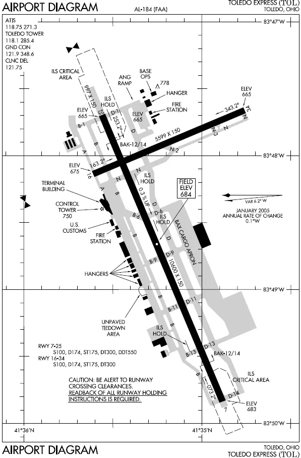
Toledo Express Airport in Lucas County is an airfield (IATA: TOL, ICAO: KTOL). Toledo Express Airport is also known as TOL. Ⓦ.
- Website
- https://www.toledoexpress.com/
Streets nearby
Maumee-Western RoadRoberts Chapel, Swan Creek Church
0.2 mi
Susan Lane0.4 mi
Whitehouse-Spencer Road0.5 mi
Airport Service Road0.6 mi
South Airfield Road0.7 mi
LaPlante Road0.9 mi
TR 800101.1 mi
Air Cargo Parkway East1.1 mi
Weckerly Road1.2 mi
Turkeyfoot Loop1.2 mi
Terminal Parkway1.3 mi
East Airport Service Drive1.3 mi
South Eber Road1.3 mi
Airport HighwayEast Swanton
1.3 mi
Sager Road1.3 mi
West Airport Service Road1.4 mi
Whitehouse Spencer Road1.5 mi
South Berkey-Southern Road1.5 mi
Lupine Trail1.5 mi
Airport Hwy / Rt 2 Exit1.5 mi
Wabash Cannonball Trail (North Fork)1.6 mi
Chateau Estates1.6 mi
South Berkey Southern RoadMidway
1.6 mi
Elm1.7 mi
Birch1.7 mi
Walnut1.7 mi
Pine1.7 mi
Ohio TurnpikeSwanton
1.7 mi
Redwood1.7 mi
Garden Road1.7 mi
Reed Road1.7 mi
Chesnut1.7 mi
Cherry1.7 mi
Willow1.8 mi
Buckeye1.8 mi
Shaffer Road2.0 mi
Mescher Drive2.0 mi
Buildings nearby
ILS1.2 mi
Aerospace and Natual Science Academy of Toledo1.5 mi
Hangars nearby
Grand Aire Express1.5 mi
Military areas nearby
180th Fighter Wing0.3 mi
Air National Guard0.9 mi
Nature reserves nearby
Louis W. Campbell State Nature Preserve1.2 mi
Police stations nearby
Ohio State Highway Patrol1.6 mi
Pubs nearby
Eds Bar and BBQ0.6 mi
Quarries nearby
Seaway Sand & Stone1.6 mi
Railways nearby
NS Chicago Line2.0 mi
Residential areas nearby
Chateau Estates Mobile Home Park1.7 mi
School buildings nearby
Aviation Center1.6 mi
| Named after | Toledo |
|---|---|
| Elevation | 208.5 m |
| Located in | Ohio |
| Country | United States |
Public transit map Monclova Township Legend
| Railway | |
| Bus | |
| Streetcar |
Bicycle map Monclova Township Legend
| Bike path | |
| Bike lane on roadway | |
| Cycling allowed on bus lane | |
| Bicycle street | |
| Open to cyclists | |
| Open to cyclists, good path | |
| Cycling prohibited | |
| Cobblestone |
| Long-distance bike route | (depending on scale) | |
| Long-distance bike route |
Pedestrian map Monclova Township Legend
| Path |
| Long-distance hiking trail | (depending on scale) | |
| Long-distance hiking trail | ||
| Pedestrians prohibited |