Earth Science and Remote Sensing Unit , Lyndon B. Johnson Space Center, Public domain – Wikimedia Commons
Ohio
This page is the City map of Ohio, a state in the United States showing streets, paths and places. Ohio covers about 116,096 square kilometres and lies at an elevation of approximately 260 metres. Its population increased from 11,536,504 in 2010 to 11,799,448 in 2020. Founded as a state in 1803, Ohio includes 88 counties and major cities such as Columbus, Cleveland, Cincinnati and Dayton.
Ohio contains four long-distance bicycle routes, including United States Bicycle Route 30. The state extends from Lake Erie in the north to the Ohio River along its southern border, with the Cuyahoga, Scioto, Miami and Muskingum among its major rivers.
Warren County is a county in southwestern Ohio with a recorded population of 242,337. Its county seat is Lebanon, while Mason and Franklin are among the larger communities. The county was established in 1803 and lies between the Great Miami River and the Little Miami River. Kings Island amusement park is located near Mason.
Clermont County lies east of Cincinnati and had a recorded population of 208,601. The county covers about 1,185 square kilometres and was established in 1800. Batavia is the county seat, and the Little Miami River crosses the western part of the county. Clermont County reaches the Ohio River near New Richmond.
Clinton County is located in southwestern Ohio and had a recorded population of 42,018. Its area is about 1,068 square kilometres, and the county reaches an elevation of approximately 319 metres. Wilmington is the county seat and the site of Wilmington College. Clinton County was established in 1810.
Greene County lies east of Dayton and had a recorded population of 167,966. It covers about 1,078 square kilometres and was established in 1803. Xenia is the county seat, while Beavercreek and Fairborn are major communities. The Little Miami River runs through the county and Clifton lies on its western edge.
Montgomery County is centred on Dayton and had a recorded population of 535,153. Dayton stands at the confluence of the Great Miami, Stillwater and Mad rivers. The county contains Wright-Patterson Air Force Base in the adjacent Greene County area and is associated with the Wright brothers’ aviation history. Other communities include Kettering, Trotwood and Englewood.
Butler County in southwestern Ohio had a recorded population of 390,357 and covers about 1,218 square kilometres. Hamilton is the county seat, while Middletown and Fairfield are major cities. The Great Miami River flows through the county, which was established in 1803. Miami University is located in Oxford.
Hamilton County had a recorded population of 830,639 and includes Cincinnati on the Ohio River. The county was established in 1790, making it one of Ohio’s oldest counties. Cincinnati is known for the Roebling Suspension Bridge, Findlay Market and the Cincinnati Museum Center at Union Terminal. The Mill Creek and the Little Miami River also cross the county.
Brown County lies along the Ohio River in southwestern Ohio and had a recorded population of 43,676. It covers about 1,283 square kilometres and was established in 1818. Georgetown is the county seat, and Ripley stands on the Ohio River. The county is part of the rolling Appalachian foothills east of Cincinnati.
Franklin County had a recorded population of 1,323,807 and contains Columbus, the capital of Ohio. The county covers about 1,408 square kilometres and was established in 1803. The Scioto River passes through downtown Columbus, where the Ohio Statehouse and Ohio State University are located. Dublin, Westerville and Reynoldsburg are among the other major communities.
Madison County in central Ohio had a recorded population of 43,824. It covers about 1,207 square kilometres and was established in 1810. London is the county seat, located west of Columbus near the headwaters of the Little Darby Creek. The county’s landscape is part of the flat to gently rolling Central Ohio plain.
Union County north of Columbus had a recorded population of 62,784. It covers about 1,132 square kilometres and was established in 1820. Marysville is the county seat and a centre for manufacturing and services. The Scioto River and several tributary streams drain the county toward central Ohio.
Delaware County north of Columbus had a recorded population of 214,124 and covers about 1,181 square kilometres. The county was established in 1808, with Delaware as its county seat. Alum Creek Lake and Alum Creek State Park are prominent features east of the city. Westerville extends across the southern county boundary into Franklin County.
Licking County east of Columbus had a recorded population of 178,519 and covers about 1,783 square kilometres. Newark is the county seat and contains the Newark Earthworks, a major prehistoric geometric earthwork complex. The county was established in 1808, and the Licking River flows through Newark. Buckeye Lake lies on the western side near the Fairfield County line.
Fairfield County southeast of Columbus had a recorded population of 158,921 and covers about 1,317 square kilometres. Lancaster is the county seat, and the county was established in 1800. The Hocking River passes through Lancaster before joining the Ohio River system. Fairfield County includes Buckeye Lake and part of Canal Winchester.
Pickaway County south of Columbus had a recorded population of 56,998. Circleville is the county seat and lies beside the Scioto River. The county’s name is associated with the Pickaway Plains, a historic landscape along the river. Pickaway County borders Franklin, Fairfield, Hocking, Ross and Fayette counties.
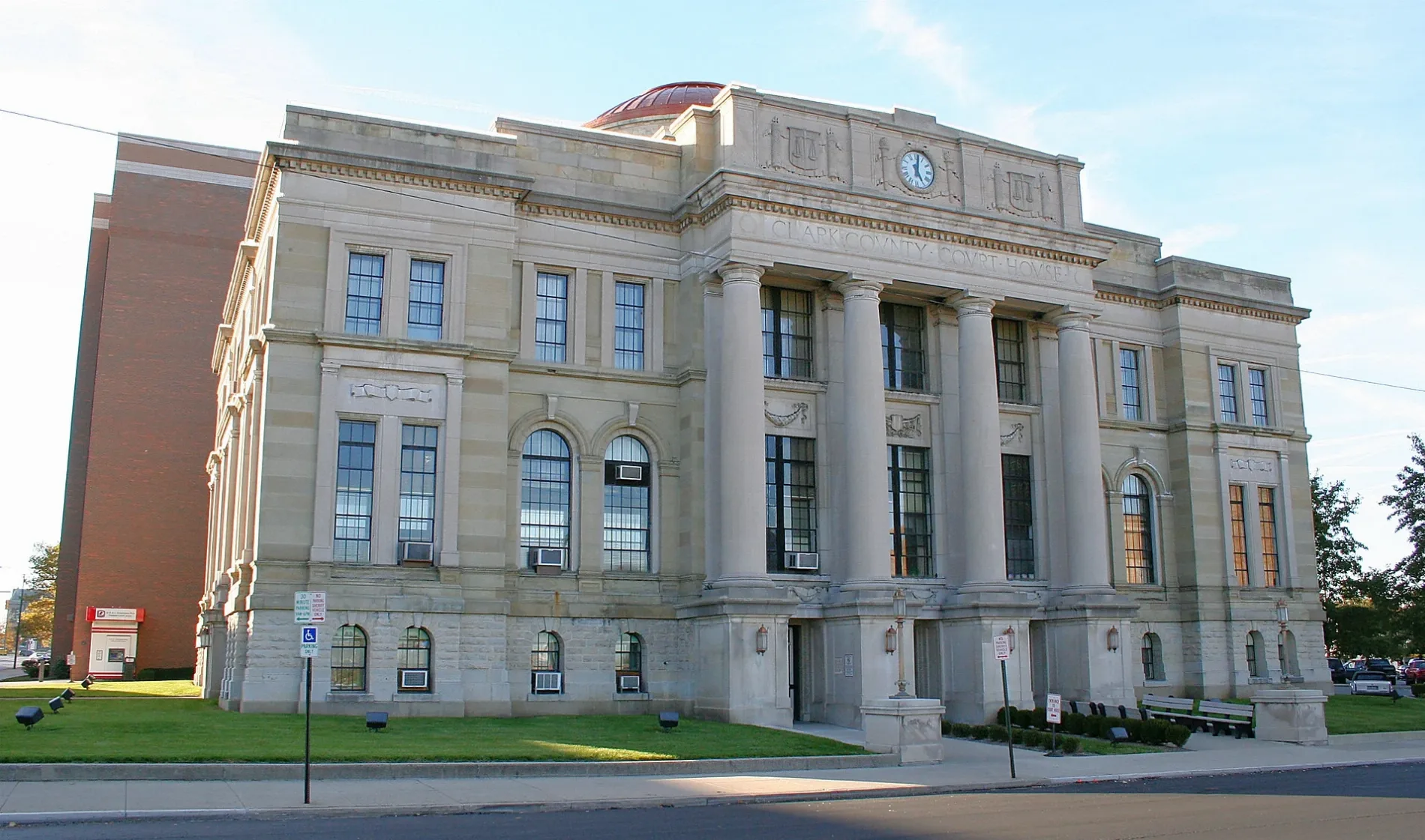
Clark County in southwestern Ohio had a recorded population of 136,001 and covers about 1,045 square kilometres. Springfield is the county seat and was established as the county seat in the nineteenth century. The county was established in 1818 and contains the Mad River, a tributary of the Great Miami River. Clifton extends across the Clark and Greene county boundary.
Champaign County in west-central Ohio had a recorded population of 40,097. Urbana is the county seat and lies near the Mad River’s upper drainage basin. The county borders Clark County to the southwest and Union County to the north. Its agricultural landscape forms part of the Central Till Plain.
Sharonville is a city in southwestern Ohio with a recorded population of 13,560. It lies mainly in Hamilton County along the Mill Creek corridor. The city is north of Cincinnati and near Interstate 75 and Interstate 275. Sharonville is part of the Cincinnati metropolitan area.
Monroe is identified as a city in Ohio. The community lies in the southwestern part of the state, within the Cincinnati and Dayton urban corridor. Ohio State Route 63 connects Monroe with Middletown and Lebanon. The place name is shared by communities in several United States states.
Middletown is a city in Butler and Warren counties with a recorded population of 50,987. It covers about 68.4 square kilometres and stands at approximately 200 metres above sea level. The Great Miami River runs through the city, which was established in 1833. Middletown lies between Cincinnati and Dayton.
Mogadore is a village in northeastern Ohio near Akron. It lies in Summit County close to the Little Cuyahoga River and Mogadore Reservoir. State Route 532 connects the village with Akron and communities in Portage County. Mogadore is part of the Akron metropolitan area.
Washingtonville is a village in northeastern Ohio. It lies in Mahoning County near the Mahoning River valley. The village is south of Youngstown and east of Salem. Local roads connect Washingtonville with Leetonia and neighboring communities.
Buchtel is a village in southeastern Ohio with a recorded population of 518. It covers about 1.26 square kilometres and stands at approximately 206 metres above sea level. The village is in Athens County near the Hocking River watershed. Buchtel is located close to Nelsonville and Athens.
Yorkville is a village in Belmont and Jefferson counties with a recorded population of 968. It lies along the Ohio River in eastern Ohio. The village is near Martins Ferry and Steubenville, with the river forming the regional corridor. Yorkville is connected to the Ohio Valley road network.
Hunting Valley is a village in Cuyahoga and Geauga counties with a recorded population of 763. It covers about 20.8 square kilometres and stands at approximately 233 metres above sea level. The village lies east of Cleveland in the Chagrin River watershed. Its location places it within the Cleveland metropolitan area.
Buckeye Lake is a village in Fairfield County with a recorded population of 2,520. It covers about 5.16 square kilometres and stands at approximately 276 metres above sea level. The community lies beside Buckeye Lake, a reservoir east of Columbus. The lake was developed from a canal feeder reservoir associated with the Ohio and Erie Canal.
Vermilion is a city on Lake Erie in northern Ohio with a recorded population of 10,659. It covers about 28.0 square kilometres and stands at approximately 181 metres above sea level. The city lies at the mouth of the Vermilion River between Cleveland and Sandusky. Vermilion was established in 1834 and has a harbor on Lake Erie.
Bradford is a village in Darke and Miami counties with a recorded population of 1,796. It covers about 2.22 square kilometres and stands at approximately 301 metres above sea level. The village was established in 1865 in western Ohio. Bradford lies north of Piqua and west of Troy.
Canal Winchester is a city in Fairfield and Franklin counties with a recorded population of 9,107. It covers about 19.7 square kilometres and stands at approximately 233 metres above sea level. The city was established in 1828 along the historic Ohio and Erie Canal route. It lies southeast of Columbus near the Big Walnut Creek watershed.
Lynchburg is a village in Clinton and Highland counties with a recorded population of 1,510. It covers about 2.45 square kilometres and stands at approximately 307 metres above sea level. The village lies east of Cincinnati in the rural southwestern Ohio landscape. Lynchburg is near the East Fork of the Little Miami River.
Swanton is a village in northwestern Ohio in Fulton and Lucas counties. It lies west of Toledo near the Swan Creek watershed. U.S. Route 20 and State Route 64 connect the village with Toledo and western Ohio. Swanton is part of the Toledo metropolitan area.
Roseville is a village in central Ohio near the Muskingum River valley. It lies in Muskingum and Perry counties east of Columbus. State Route 719 connects the village with Zanesville and surrounding communities. Roseville is known regionally for its location in Ohio’s historic pottery-producing area.
Gratiot is a village in Licking and Muskingum counties with a recorded population of 215. It covers about 0.35 square kilometres and stands at approximately 301 metres above sea level. The village was established in 1829 in central eastern Ohio. Gratiot lies near the Licking River drainage and U.S. Route 40.
Green Springs is a village in northwestern Ohio in Sandusky and Seneca counties. It lies near the Sandusky River, between Fremont and Tiffin. The community is connected with the Lake Erie plain and the western Ohio rail corridor. State Route 19 passes near Green Springs.
Plain City is a village in Madison and Union counties with a recorded population of 4,225. It lies northwest of Columbus near the Big Darby Creek watershed. The village is connected to Dublin and Marysville by State Route 161 and U.S. Route 42. Plain City is part of the expanding Central Ohio urban region.
Ridgeway is a village in Hardin and Logan counties with a recorded population of 314. It covers about 1.53 square kilometres and stands at approximately 323 metres above sea level. The village was established in 1851 in west-central Ohio. Ridgeway lies near the upper Scioto River drainage.
Burkettsville is a village in western Ohio in Darke County. It lies near the Indiana state line and the upper Greenville Creek watershed. The village is south of Versailles and west of Greenville. Local roads connect Burkettsville with rural communities in Darke County.
Loudonville is a village in Ashland and Holmes counties with a recorded population of 2,786. It covers about 7.16 square kilometres and stands at approximately 294 metres above sea level. The village lies on the Black Fork of the Mohican River. Loudonville is near Mohican State Park and the hills of north-central Ohio.
New Albany is a city in Franklin and Licking counties northeast of Columbus. It lies near the Rocky Fork and the headwaters of Big Walnut Creek. State Route 161 provides a major connection with Columbus and Granville. The city is part of the Columbus metropolitan area.
Plymouth is a village in Richland and Huron counties in north-central Ohio. It lies near the headwaters of the Huron River and south of Sandusky. State Route 61 connects Plymouth with Mansfield and Norwalk. The village is situated on the agricultural Lake Erie plain.
Magnolia is a village in Stark and Carroll counties in eastern Ohio. It lies near the Sandy Creek watershed south of Canton. U.S. Route 183 connects the village with Waynesburg and Alliance. The surrounding terrain forms part of the Appalachian Plateau transition zone.
Minerva is a village in Stark, Carroll and Columbiana counties with connections to the Sandy Creek valley. It lies east of Canton and west of Lisbon. The village is served by State Route 183 and regional rail lines. Minerva is located in the foothill landscape of eastern Ohio.
Columbiana is a city in Columbiana and Mahoning counties with a recorded population of 6,559. It covers about 16.2 square kilometres and stands at approximately 353 metres above sea level. The city was established in 1805 and lies near the Middle Fork of the Little Beaver Creek. Columbiana is south of Youngstown and east of Salem.
Westerville is a city in Franklin and Delaware counties with a recorded population of 39,190. It stands at approximately 267 metres above sea level northeast of Columbus. The city was established in 1858 and is associated with Otterbein University. Westerville lies near Alum Creek and Hoover Reservoir.
Loveland is a city in Clermont, Hamilton and Warren counties with a recorded population of 13,307. It covers about 13.2 square kilometres and stands at approximately 182 metres above sea level. The city was established in 1876 along the Little Miami River. Loveland is located northeast of Cincinnati.
Milford is a city in Clermont and Hamilton counties with a recorded population of 6,582. It covers about 10.0 square kilometres and stands at approximately 167 metres above sea level. The city was established in 1802 along the Little Miami River. Milford lies east of Cincinnati near the Little Miami Scenic Trail corridor.
New Holland is a village in Pickaway County in central Ohio. It lies south of Columbus near the Scioto River basin. State Route 762 connects the village with Ashville and the southern Columbus area. The surrounding land belongs to the agricultural plain of central Ohio.
Verona is a village in western Ohio in Montgomery and Miami counties. It lies north of Dayton near the Stillwater River watershed. State Route 202 connects Verona with Vandalia and Tipp City. The village is part of the Miami Valley region.
College Corner is a village in Butler and Preble counties with a recorded population of 387. It covers about 0.68 square kilometres and stands at approximately 299 metres above sea level. The village lies directly on the Ohio–Indiana state line. Its name refers to its location near Miami University in Oxford, Ohio.
Union is a city in Montgomery County in southwestern Ohio. It lies north of Dayton near the Stillwater River and the Great Miami River basin. U.S. Route 40 and State Route 48 connect Union with Dayton and Clayton. The city is part of the Miami Valley metropolitan area.
Huber Heights is a city in Montgomery, Miami and Greene counties with a recorded population of 43,439. It covers about 57.9 square kilometres and stands at approximately 284 metres above sea level. The city was established in 1980 north of Dayton. Interstate 70 crosses Huber Heights near the Mad River.
Wilson is a village in Belmont and Monroe counties with a recorded population of 129. It covers about 1.21 square kilometres and stands at approximately 381 metres above sea level. The village lies in eastern Ohio near the Ohio River hills. Local roads connect Wilson with communities in the upper Ohio Valley.
Fairview is a village in Ohio. Several Ohio communities use the name Fairview, including places in Guernsey, Noble and Monroe counties. The village designation identifies a small incorporated settlement rather than a county-level jurisdiction. Its local road connections follow the rural county network.
Clifton is a village in Clark and Greene counties with a recorded population of 131. It covers about 0.48 square kilometres and stands at approximately 306 metres above sea level. The village was established in 1840 beside the Little Miami River. Clifton lies near Yellow Springs and the John Bryan State Park area.
Reynoldsburg is a city at the tripoint of Franklin, Licking and Fairfield counties with a recorded population of 41,076. It covers about 29.1 square kilometres and stands at approximately 268 metres above sea level. The city was established in 1802 east of Columbus. Blacklick Creek and State Route 256 cross the Reynoldsburg area.
Adena is a village in eastern Ohio in Harrison County. It lies near the Conotton Creek watershed south of Steubenville. State Route 151 connects Adena with Cadiz and Smithfield. The surrounding landscape belongs to the Appalachian Plateau.
Milan is a village in Erie and Huron counties in northern Ohio. It lies south of Lake Erie near the Huron River and east of Sandusky. Milan is associated with Thomas Edison, who was born there in 1847. The village is connected to Norwalk and Sandusky by State Route 250.
Bellevue is a city in northern Ohio with a recorded population of 8,249. It covers about 16.2 square kilometres and stands at approximately 229 metres above sea level. The city lies in Erie, Huron, Sandusky and Seneca counties near the Sandusky River watershed. Bellevue is southwest of Sandusky and northwest of Mansfield.
United States Senate Committee on Armed Services, Public domain – Wikimedia Commons
Scott is a village in Van Wert and Paulding counties with a recorded population of 242. It covers about 2.10 square kilometres and stands at approximately 224 metres above sea level. The village lies in northwestern Ohio near the Auglaize River watershed. State Route 116 connects Scott with Van Wert and surrounding rural communities.
Creston is a village in Medina and Wayne counties with a recorded population of 2,139. It covers about 5.84 square kilometres and stands at approximately 302 metres above sea level. The village lies between Medina and Wooster in north-central Ohio. Creston is near the headwaters of the Chippewa Creek and the Ohio & Erie Canal corridor.






 Public transit map Ohio Legend
  Bicycle map Ohio Legend
  Pedestrian map Ohio Legend