
Hatbox Field in Muskogee, Oklahoma
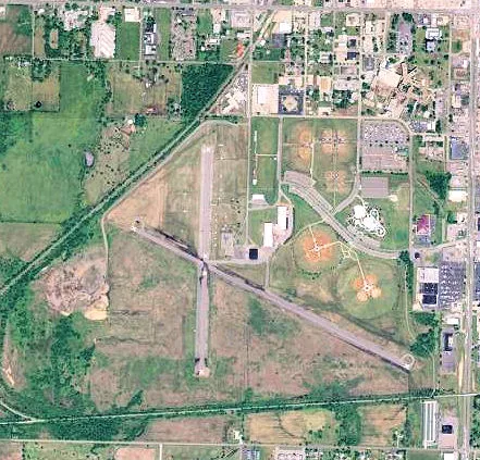
Hatbox Field in Muskogee is a park. Hatbox Field is also known as HAX. Hatbox Field is located near Centennial Trail. Ⓦ.
- Leisure
- park
Image
Gas stations
Rental services
Pharmacies
Cell phone stores
ATMs
Places of worship
Convenience stores
Fast food restaurants
Liquor stores
Vape shops
Motels
Doctor's offices
Hotels
Colleges
Beauty salons
Streets nearby
Centennial Trail0.1 mi
West Border Avenue0.2 mi
South Hatbox Road0.4 mi
Border Trail0.5 mi
South 40th Place0.5 mi
South 54th Street0.6 mi
Crest Court0.6 mi
Crestview Avenue0.6 mi
South 39th Place0.6 mi
Hatbox Loop Trail0.6 mi
Pine Street0.6 mi
South 38th Street0.7 mi
Estelle Avenue0.7 mi
South 55th Street0.7 mi
Meadowbrook Drive0.7 mi
South 48th Street0.7 mi
Eaglecrest Drive0.7 mi
Even Par Avenue0.7 mi
South 43rd Street0.7 mi
South 40th StreetWest Muskogee
0.7 mi
Arline StreetCasey's General Store
0.8 mi
Denver Avenue0.8 mi
Eagle Crest Drive0.8 mi
South 54th Place West0.8 mi
South 44th Street0.8 mi
Kershaw Circle0.8 mi
North 50th Street0.9 mi
West Okmulgee AvenueCasey's General Store, U-Haul, Muskogee
0.9 mi
North 46th Street0.9 mi
West Broadway StreetFresenius Medical Group, Plaza Medical Center, Okie Medical MMJ Dispensary, Okie MMJ Doctor, Christian Center Church
0.9 mi
North 49th Street0.9 mi
Abandoned railways nearby
Missouri Pacific RR (abnd)0.7 mi
Clinics nearby
Warren Clinic0.8 mi
Hangars nearby
Hatbox Field Hangar0.6 mi
Hospitals nearby
Cornerstone Specialty Hospitals Muskogee0.7 mi
Residential areas nearby
Eagle Crest Estates0.7 mi
Westside Terrace Apartments0.7 mi
Fairview Terrace0.8 mi
The Oaks Apartments0.8 mi
Logandale Apartments0.9 mi
Villa Capri0.9 mi
Houck-Dill Subdivision0.9 mi
Oklahoma Addition0.9 mi
Restaurants nearby
My Place Bar-B-Q West0.9 mi
Self storages nearby
Avanti Self Storage0.8 mi
Sports fields nearby
Hatbox South0.7 mi
Hatbox North0.7 mi
Variety stores nearby
Family Dollar0.8 mi
Dollar General0.9 mi
| Elevation | 191 m |
|---|---|
| Located in | Oklahoma |
| Country | United States |
 Public transit map Muskogee Legend
| Railway | |
| Bus | |
| Streetcar |
 Bicycle map Muskogee Legend
| Bike path | |
| Bike lane on roadway | |
| Cycling allowed on bus lane | |
| Bicycle street | |
| Open to cyclists | |
| Open to cyclists, good path | |
| Cycling prohibited | |
| Cobblestone |
| Long-distance bike route | (depending on scale) | |
| Long-distance bike route |
 Pedestrian map Muskogee Legend
| Path |
| Long-distance hiking trail | (depending on scale) | |
| Long-distance hiking trail | ||
| Pedestrians prohibited |