
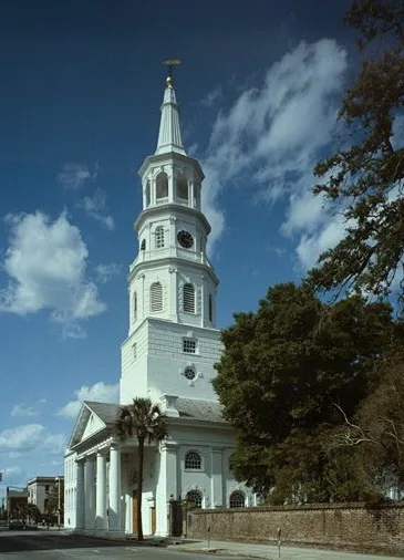
St. Michael's Anglican Church in Charleston, South Carolina
St. Michael's Anglican Church in Charleston is a religious area, Broad Street 71 (29401). St. Michael's Anglican Church is also known as St. Michael's Episcopal Church (Charleston, South Carolina). Ⓦ.
- House Number
- 71
- Street
- Broad Street
- Website
- https://www.stmichaelschurch.net
- Postal Code
- 29401
- Land Use
- religious area
Image
Museums
- South Carolina Historical Society Museum (South Carolina Historical Society, opening hours: Tue–Sat 10–16, Web) at Meeting Street 100 (29401) – approx. 350 ft.
Hair salons
Tourist information centers
Jewelry stores
Bakeries
Galleries
- Simpatico Gallery (opening hours: Mon–Fri 10–17, Web) at Broad Street 63 (29401) – approx. 350 ft.
- The George Gallery (opening hours: Tue–Sat 11–17, Web) at Broad Street 54 (29401) – approx. 450 ft.
- Jennifer McGrath Studio (opening hours: Wed–Sat 11–17; Sun 11–16, Web) at Broad Street 49 (29401) – approx. 550 ft.
- Mary Martin Gallery (opening hours: Mon–Sun 10–17, Web) at Broad Street 103 (29401) – approx. 550 ft.
Restaurants
Post offices
Doctor's offices
Clinics
Artworks
Bus stops
Clothing stores
Event venues
Stationery stores
Churches nearby
Belser Building300 ft
Commercial buildings nearby
The John Hume House250 ft
The Mansion House Hotel Annex300 ft
The Thomas Fleming House300 ft
The Robert Downie Building350 ft
Robert Downie Building350 ft
The National Freedman's Savings Bank450 ft
The Geiger House500 ft
The Clark Mills Studio500 ft
Courthouses nearby
J. Waties Waring Judicial Center250 ft
Duplexes nearby
John Cordes Prioleau House450 ft
The William Ellis Tenement550 ft
The William Ellis House0.1 mi
William Vanderhorst House0.1 mi
Event venues nearby
South Carolina Society Hall300 ft
Gardens nearby
Heyward-Washington House Gardens0.1 mi
Houses nearby
George Dingle House400 ft
Elizabeth O'Neill Verner House0.1 mi
Office buildings nearby
Cabbage Row0.1 mi
Parks nearby
Washington Square200 ft
Places of worship nearby
St. Michael's Church150 ft
Public buildings nearby
Charleston County Courthouse100 ft
United States Post Office and Courthouse200 ft
Retail buildings nearby
Hebrew Orphanage Building200 ft
The Marshall Building450 ft
Single-family houses nearby
Judge Elihu Hall Bay House300 ft
Daniel Ravenel House350 ft
James L. Petigru Building350 ft
John E. Poyas House400 ft
Philip Moore House400 ft
Robert Pringle House450 ft
Clelia McGowan House500 ft
Isaac Holmes Tenement500 ft
The Andrew Hasell House500 ft
The John T. Marshall House550 ft
Branford-Horry House Dependency550 ft
The Margaret Ducat Cleland House550 ft
The George Ducat House0.1 mi
Branford-Horry House0.1 mi
The Cleland-Wells House0.1 mi
James Vanderhorst House0.1 mi
Heyward-Washington House0.1 mi
William Harvey House0.1 mi
The Jacob Motte House0.1 mi
The John Dart House0.1 mi
The Col. George Chicken House0.1 mi
Town halls nearby
Charleston City Hall200 ft
| Heritage designation | National Historic Landmark, National Register of Historic Places listed place |
|---|---|
| Located in | Charleston |
| Country | United States |
| Has part | St. Michael's Churchyard |
Public transit map Charleston Legend
| Railway | |
| Bus | |
| Streetcar |
Bicycle map Charleston Legend
| Bike path | |
| Bike lane on roadway | |
| Cycling allowed on bus lane | |
| Bicycle street | |
| Open to cyclists | |
| Open to cyclists, good path | |
| Cycling prohibited | |
| Cobblestone |
| Long-distance bike route | (depending on scale) | |
| Long-distance bike route |
Pedestrian map Charleston Legend
| Path |
| Long-distance hiking trail | (depending on scale) | |
| Long-distance hiking trail | ||
| Pedestrians prohibited |