
Heights Fire Station in Houston
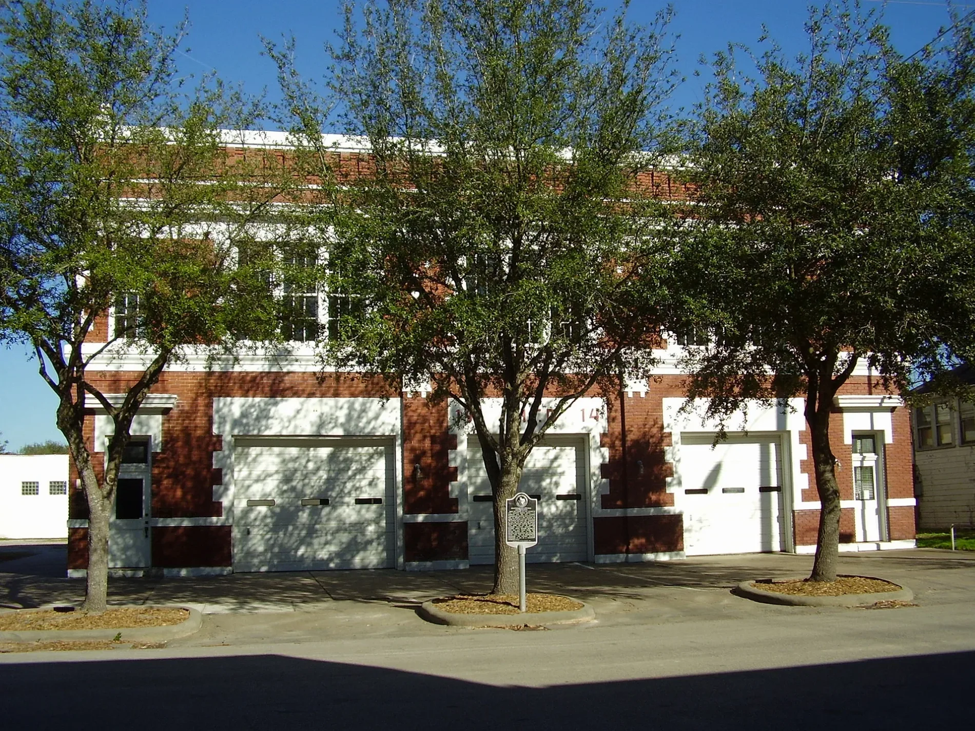
Heights Fire Station in Houston is an event venue (Houston Heights Association), West 12th Street 107 (77008) 🌐. Heights Fire Station is also known as Houston Heights City Hall & Fire Station. Heights Fire Station is built in the Tudor Revival architecture style and is made of brick and cast stone. Ⓦ.
- House Number
- 107
- Postal Code
- 77008
- Street
- West 12th Street
- Amenity
- event venue
- Building Type
- building
- Operator
- Houston Heights Association
- Website
- https://heightsfirestationvenue.com/
Image
Tourist information centers
Dentist offices
Theaters
Convenience stores
Cosmetics stores
Jewelry stores
Places of worship
Bike shops
Liquor stores
Clothing stores
Restaurants
Fast food restaurants
Garden centers
Banks
Music schools
Streets nearby
West 11th StreetDish Society, Mattress Firm, West Eleventh Church of God, CBD American Shaman, Revolucion Coffee + Juice, I Know The Owner
0.2 mi
Allston Street0.2 mi
West 10½ Street0.2 mi
Cortlandt StreetBudget, Shell
0.2 mi
Yale StreetSaint Albans Catholic Church, Blue Line Bike Lab, Area 52, Lola, Jimmy John's, Crumbl Cookies, Wingstop, Premier Fine Wine & Spirits, Great Clips, Aqua Cleaners, Total Nutrition, Smashburger, BLVD Dentistry, Luna Pizzeria, Massage Heights, GNC, Nail Time, Noon Mediterranean, Subway, Texas Children's Pedatrics, Lovejoy's, Heights Antiques on Yale, Dentist Tree of The Heights, Replay Games, Bank of America, Kim Liquor, Wild Boar Barbershop, CVS Pharmacy, Airline Medical Clinic, Taqueria No Toques Mi Taco, Corner Bakery, Doctors Express Urgent Care, Verizon, Flash Dental, Starbucks, Mattress Firm, Kendra Scott, Lemon Laine, The Impeccable Pig, Pressed, Shipley Do-Nuts, Yale Store, Valero
0.2 mi
Heights BoulevardThe Boardroom, Salata, Clear Smiles, Barnaby's Cafe, Ideal Image, Heights Christian Church, The Houston Saengenbund, Arcadia, 3rd Generation Ink, Retreat Massage, The Monk's Kitchen, Water Tree, TJ's Smoke Shop, Subway
0.2 mi
East 12th Street0.3 mi
Tulane Street0.3 mi
Harvard StreetBonjour, Metro by T-Mobile, Star Pizza, First Baptist Church Heights
0.3 mi
West 10th StreetPepperoni's, Elder Son Brewing Co., Polished Nail Lounge
0.3 mi
West 14th Street0.3 mi
Columbia Street0.3 mi
East 10th StreetShokku Ramen, Maison Pucha Bistro
0.3 mi
East 13th StreetHeights High School Theatre, Heights High School
0.3 mi
East 14th StreetHoward Locksmith Heights, Latina Mission Presbyterian Church
0.3 mi
West 15th StreetHouston Heights, CubeSmart, Flying Squid Tattoo
0.4 mi
East 15th Street0.4 mi
Arlington StreetMemorial Hermann Urgent Care
0.4 mi
Paul Carr Jogging TrailLombard Lamp
0.4 mi
West 16th StreetCircle K
0.5 mi
West 17th Street0.6 mi
Buildings nearby
Lula J Doughty House400 ft
Miller House500 ft
Johnson, Johnson & Baer, P.C.0.2 mi
Hope & Causey0.2 mi
Webber House0.2 mi
Houston Finance Co0.2 mi
Moses A Clanton House0.3 mi
Parish Office0.3 mi
Love House0.4 mi
Doctor Billie V Ellis House0.4 mi
Doctor B F Coop House0.5 mi
The Stout Law Firm P.L.L.C.0.5 mi
Barker House0.5 mi
Woodward House0.5 mi
Milroy-Muller House0.5 mi
Glenn W Morris House0.5 mi
Cafes nearby
EQ Heights0.2 mi
Community centers nearby
Milroy Community Center400 ft
Fire stations nearby
Heights Fire Department150 ft
Fitness centers nearby
Citizen Pilates0.3 mi
Libraries nearby
Heights Neighborhood Library0.2 mi
Music stores nearby
Fleming's Instrument Repair0.3 mi
Parks nearby
Milroy Park250 ft
Places of worship nearby
Heights Church of Christ0.5 mi
Pubs nearby
Heights & Co0.2 mi
Religious areas nearby
All Saints Catholic Church0.3 mi
School buildings nearby
All Saints School0.2 mi
Single-family houses nearby
All Saints Rectory0.3 mi
| Named after | Houston Heights |
|---|---|
| Year built | 1914 |
| Architectural style | Tudor Revival architecture |
| Material | brick, cast stone |
| Area | 1 |
| Heritage designation | National Register of Historic Places listed place, Recorded Texas Historic Landmark |
| Located in | Houston |
| Country | United States |
| Location | Houston Heights |
 Public transit map Houston Legend
| Railway | |
| Bus | |
| Streetcar |
 Bicycle map Houston Legend
| Bike path | |
| Bike lane on roadway | |
| Cycling allowed on bus lane | |
| Bicycle street | |
| Open to cyclists | |
| Open to cyclists, good path | |
| Cycling prohibited | |
| Cobblestone |
| Long-distance bike route | (depending on scale) | |
| Long-distance bike route |
 Pedestrian map Houston Legend
| Path |
| Long-distance hiking trail | (depending on scale) | |
| Long-distance hiking trail | ||
| Pedestrians prohibited |