
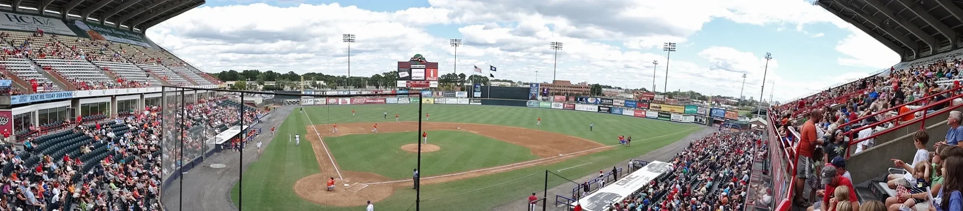
The Diamond in Richmond, Virginia
The Diamond in Richmond is a sports field (Baseball). The Diamond is located near Sherwood Avenue. Ⓦ.
- Leisure
- sports field
- Wheelchair Access
- limited
Image
Bars
Recycling stations
Cannabis dispensaries
Studios
Gas stations
Craft stores
Fast food restaurants
Banks
Car washes
Secondhand stores
Ice cream shops
Lighting stores
Restaurants
Cafes
Vending machines
Tire dealers
Specialty stores
Public bookcases
Animal shelters
Streets nearby
Avenue of Champions0.1 mi
Boulevard West0.1 mi
Sherwood AvenueMayer Electric Supply, Diversity Richmond
0.2 mi
North Arthur Ashe BoulevardTurner's Auto Service, Pizzeria Mungo, RVA Clippers, FlixBus Richmond, Chipotle, Starbucks, Toast, Custom Sign Shop, Boulevard Tire, Puritan Cleaners, Happy Trees Agricultural Supply, Potbelly, Light Tape® Electro-LuminX Lighting Corp, Helen Wapole Brewer Library, Rumors of War, Fighting Fish Scott’s Addition, Janet Brown Interiors, Xfinity, Brickhouse Diner
0.2 mi
Robin Hood RoadGate 5, RVA Financial
0.2 mi
Ellen RoadAmeriGas, Marco's Pizza, Raising Cane's
0.2 mi
Patton Road0.2 mi
Hermitage RoadRichmond SPCA, The New Community School
0.2 mi
Summit AvenueNGM Summit Market, Lunch, Little Free Library
0.3 mi
Richmond-Petersburg TurnpikeRichmond ToolBank, City of Richmond Recycling Center, Richmond Electric Supply
0.3 mi
Altamont AvenueSound of Music Recording Studios, Class and Trash At Scott's Addition, Mincz Tire, Phoenix Hand Craft, Lillian, Recluse Coffee Bar and Roastery, Wax Moon, Lost Letter
0.3 mi
Little John Road0.3 mi
Norfolk StreetGelati Celesti, Pinky's
0.3 mi
Myers StreetFleet Fueling, VA Imports, Autopart International
0.4 mi
Rhoadmiller StreetHelping Hands Veterinary, Virago Spirits, Susan M. Markle Veterinary Hospital at Richmond SPCA, Gexpro, Richmond SPCA Pet Pantry
0.4 mi
West Leigh StreetLucky AF: Asian Fusion & Sushi, Strangeways Brewing RVA-Scott's Addition, Smohk, Buskey Cider, Starr Hill Beer Hall & Rooftop, Eazzy Burger, Little Free Library, Fat Dragon Chinese Kitchen & Bar, No. 1 Bus Station
0.4 mi
Cummings Drive0.4 mi
Hardy Street0.4 mi
Overbrook Road0.4 mi
Durham StreetDiversity Thrift
0.5 mi
Apartment buildings nearby
The Lofts0.3 mi
Bars nearby
The Park RVA0.5 mi
Buildings nearby
Workpath0.3 mi
Impact Makers0.3 mi
Richmond Ambulance Authority0.4 mi
Hardywood Park Craft Brewery0.5 mi
Buildings under construction nearby
Boulevard Burger and Brew0.4 mi
Cafes nearby
Afterglow Coffee Cooperative0.3 mi
Construction sites nearby
NOVEL Scott's Addition0.1 mi
Convenience stores nearby
Wawa0.2 mi
Electrical supply stores nearby
Electrical Equipment Company | EECO0.2 mi
Industrial areas nearby
Supervalu0.4 mi
Industrial buildings nearby
Cosentino0.4 mi
Michael & Son Services0.5 mi
Motels nearby
Diamond Inn & Suites0.2 mi
Movie theaters nearby
Movieland0.3 mi
Criterion Cinemas0.4 mi
Places of worship nearby
Thrive Church0.3 mi
Pubs nearby
Isley Brewing Company0.3 mi
Railways nearby
Richmond Terminal Subdivision0.4 mi
Bellwood Subdivision0.5 mi
Rental services nearby
U-Haul0.1 mi
Residential areas nearby
Symbol Apartments0.3 mi
Restaurants nearby
Richard's Restaurant & Gentlemen's Club0.2 mi
Specialty stores nearby
Wurth0.4 mi
Sports centers nearby
Arthur Ashe Junior Athletics Center0.1 mi
Sports fields nearby
Parker Field Annex0.2 mi
Stadiums nearby
Sports Backers Stadium0.1 mi
Stations nearby
Greyhound Bus Station0.2 mi
| Year built | 1985 |
|---|---|
| Official opening | 1985 |
| Country | United States |
 Public transit map Richmond Legend
 | Railway | |
| Bus | |
| Streetcar |
 Bicycle map Richmond Legend
 | Bike path | |
| Bike lane on roadway | |
| Cycling allowed on bus lane | |
| Bicycle street | |
| Open to cyclists | |
| Open to cyclists, good path | |
| Cycling prohibited | |
| Cobblestone |
| Long-distance bike route | (depending on scale) | |
| Long-distance bike route |
 Pedestrian map Richmond Legend
 | Path |
| Long-distance hiking trail | (depending on scale) | |
| Long-distance hiking trail | ||
| Pedestrians prohibited |