Cartogiraffe.com

Nova Scotia

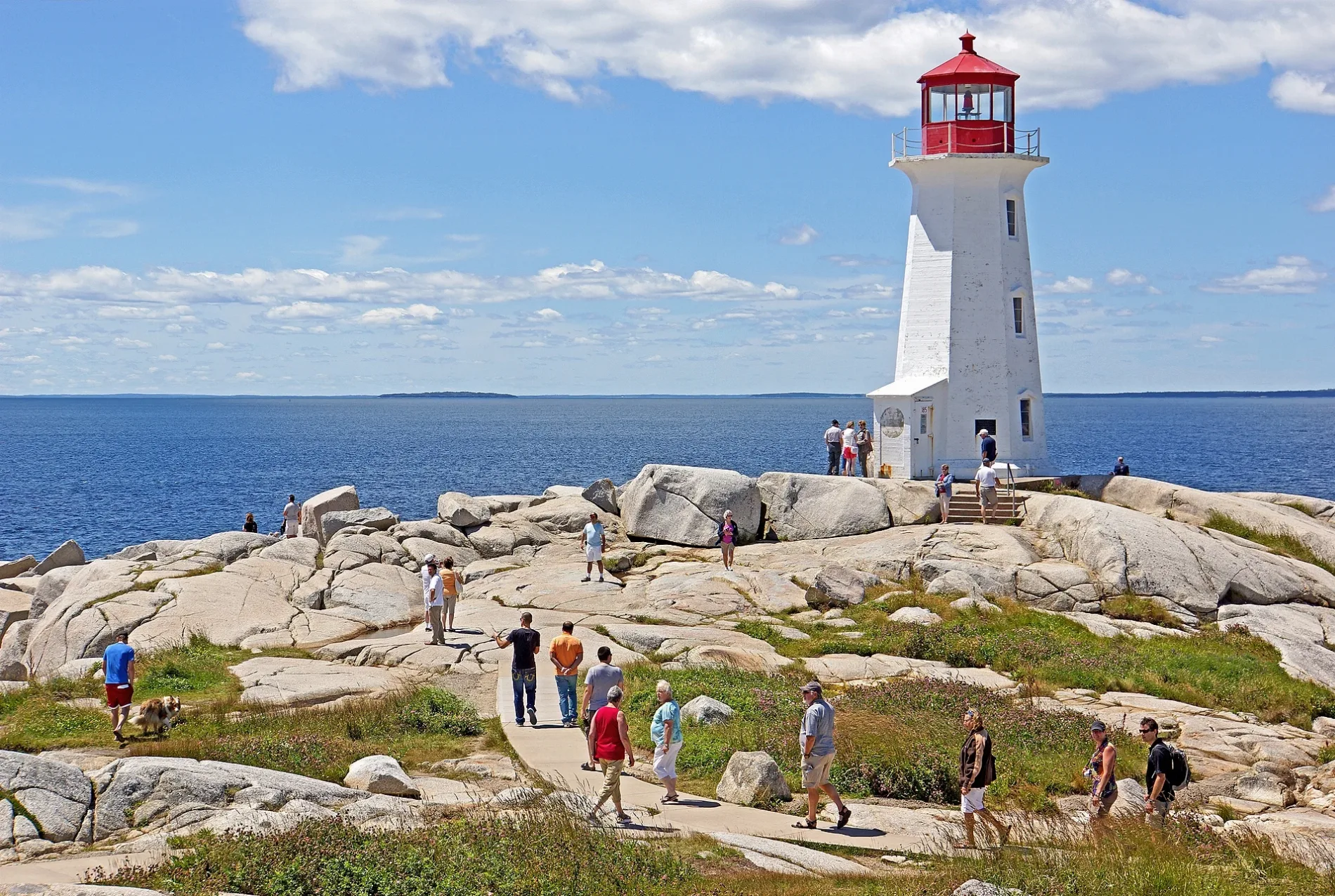
Lighthouse Dsc01066 Peggy's Cove Lighthouse (7612052968)
In the summer months it is almost impossible to get picture here without people everywhere. Tourists from bus tours and cruise ships that come to Halifax are the main reason, but it is also a very popular spot by the local people as it is only a short ride from the city and has cool breezes in the summer. The is without a doubt the most well known lighthouse in Canada and one of the most photographed lighthouses in the world, the history of the light at Peggy's Cove is little known. Various versions account for the name. Peggy is the nickname for Margaret and the community may have acquired the name from nearby Saint Margaret's Bay, especially as the point marks the eastern entrance to the bay. Other accounts suggest Peggy was an early settler. A popular romantic version says a woman named Peggy was the only survivor of a shipwreck and there are even American families that claim descent from the shipwrecked Peggy. It was decided to erect a light to mark the eastern entrance to St. Margaret's Bay in 1868. While best known as "the Peggy's Cove Lighthouse", it was and remains, officially know as the Peggy's Point Lighthouse as its purpose is to mark the point, not the cove. The cove has its own small light on the government wharf. The first lighthouse was a wooden tower, built atop a keeper's dwelling at the point. It was a red light and used a catoptric reflector (a round silver-plated mirror) to magnify the kerosene oil lamp. The wooden tower, built atop a keeper's dwelling was replaced by the present tower in 1915, a pleasing and stout concrete octagon 15.24 meters (50ft) west of the original light. The keeper's dwelling remained for many years nearby as did a tall flagpole displaying coded black cones and balls to warn of bad weather approaching. The new lighthouse showed a white light from a dioptric lens, a series of glass prisms, to magnify the light. Several colour and character changes followed, the most recent being the change from white to green and then to – Dennis G. Jarvis, CC BY-SA 2.0 – Wikimedia Commons
Nova Scotia is located in Canada. The area is situated on the Atlantic Ocean and Bay of Fundy. Around 923,598 people live here. Between 2011 and 2022, the population grew from 921,727 to 1,030,953. Its area extends over around 55,283.0 square kilometres. The region is divided into 18 Counties. The region was founded in the year 1867. The postal codes are B. The name goes back to Scotland (country) Nova Scotia is province of Canada. For more information, see novascotia.ca.
Named after Scotland
Inception 1867
Area 55283 km²
Located in Canada
Postal code B
Country Canada
Body of water Atlantic Ocean, Bay of Fundy, Gulf of Saint Lawrence, Northumberland Strait
Population 969383
Website https://novascotia.ca/
Native label Nova Scotia
Official name New Scotland
Described by source New Encyclopedic Dictionary, Encyclopædia Britannica 11th edition, The New Student's Reference Work

Map pin Nova Scotia

Public transport map Public transport map Nova Scotia Legend
Railway
Bus
Tram
Cycling map Cycling map Nova Scotia Legend
Cycle path
Cycle lane on road
Cycling on bus lane
Bicycle street
Cyclists allowed
Cyclists allowed, good surface
No cycling
Cobblestones
Long-distance cycle route (depending on scale)
Long-distance cycle route
Walking map Walking map Nova Scotia Legend
Path
Long-distance hiking trail (depending on scale)
Long-distance hiking trail
No pedestrians
Nova Scotia
Lunenburg County
Municipality of the District of Lunenburg
Chester District Municipality
Town of Lunenburg
Acadia First Nation
Town of Bridgewater
Town of Mahone Bay
Sipekne’katik First Nation
Acadia First Nation
Queens County
Region of Queens Municipality
Acadia First Nation
Shelburne County
Municipality of the District of Shelburne
Municipality of the District of Barrington
Town of Lockeport
Town of Shelburne
Town of Clark's Harbour
Halifax County
Millbrook First Nation
Halifax Regional Municipality
Millbrook First Nation
Sipekne’katik First Nation
Yarmouth County
Argyle Municipal District
Yarmouth Municipal District
Town of Yarmouth
Acadia First Nation
Acadia First Nation
Digby County
Clare Municipal District
Digby Municipal District
Town of Digby
Bear River First Nation
Annapolis County
Municipality of the County of Annapolis
Town of Annapolis Royal
Town of Middleton
Bear River First Nation
Kings County
Glooscap First Nation
Town of Kentville
Town of Berwick
Town of Wolfville
Camp Aldershot
Municipality of the County of Kings
CFB Greenwood
Annapolis Valley First Nation
Cumberland County
Town of Amherst
Municipality of the County of Cumberland
Town of Oxford
Pictou Landing First Nation
Guysborough County
St. Mary's District Municipality
Guysborough District Municipality
Town of Mulgrave
Richmond County
Potlotek First Nation
Municipality of the County of Richmond
Antigonish County
Paqtnkek Mi’kmaw Nation
Municipality of the County of Antigonish
Town of Antigonish
Pictou County
Town of Trenton
Town of Westville
Town of Trenton
Town of Stellarton
Town of New Glasgow
Municipality of Pictou County
Town of Pictou
Pictou Landing First Nation
Colchester County
Town of Truro
Town of Stewiacke
Millbrook First Nation
Municipality of Colchester
Millbrook First Nation
Inverness County
Municipality of the County of Inverness
Town of Port Hawkesbury
We'koqma'q First Nation
Malagawatch 4
Margaree 25
Wagmatcook First Nation
Cape Breton Highlands National Park
Malagawatch 6
Victoria County
Municipality of Victoria County
Wagmatcook First Nation
Cape Breton Highlands National Park
Cape Breton County
Cape Breton Regional Municipality
Membertou First Nation
Eskasoni First Nation
Fortress of Louisbourg National Historic Park
Eskasoni First Nation
Hants County
Region of Windsor and West Hants Municipality
East Hants District Municipality
Sipekne’katik First Nation
Annapolis Valley First Nation