
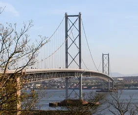
Forth Road Bridge in Edinburgh
Forth Road Bridge in City of Edinburgh is a two-lane, asphalted, lit expressway. It runs as a one-way street in a south-north direction and ends in a cul-de-sac. This road is part of the long-distance road "A9000". Forth Road Bridge also exists in North Queensferry. Ⓦ.
- Bicycle
- no
- Road Type
- expressway
- Lanes
- 2
- Speed Limit
- 50 mph
- Operator
- Forth Estuary Transport Authority
- Route
- north-south
Image
Roads nearby
Forth Road Bridge (West Cycleway)North Access, Forth Road Bridge South Tower, Forth Road Bridge North Tower, Now you see them, Three Bridges, three centuries, Fife Coastal Path, North Queensferry
100 m
Forth Road Bridge (East Cycleway)North Access, Forth Road Bridge South Tower, Forth Road Bridge North Tower
100 m
Hopetoun RoadEdwards, Queensferry Police Station, Istanbul 3 Turkish Barber, Good Fortune, Hair Chair, Deery, Optimeyes, The Wax Bar, Barclays, Neil MacLean
250 m
Stewart Terrace250 m
Bo'ness RoadEchline Corner, Springfield Crescent, Springfield View, Walker Drive
250 m
Shore RoadDown the Hatch
250 m
Springwell Terrace300 m
Villa Road350 m
Plewlandcroft400 m
Rose LaneThe Binks
400 m
Morison GardensBarnardo's, Westport Veterinary Clinic, Chilli Waves, South Queensferry Post Office
450 m
Covenanter's Lane450 m
Bell StaneQueen's Spice, Graziano's
500 m
Harbour LaneBellstane Dental Care, Harbour Lane Studio, The Harbour
500 m
Gote LaneThe Little Bakery
500 m
Ferrymuir GaitShell, Buy-Time Jetwash
550 m
Harbour HouseForth Bridges
550 m
The LoanThe Loan, Bamboo
550 m
West TerraceSouth Queensferry, Ashley Clarke Signature Salon
600 m
Old Post Office Close600 m
Brewery CloseRavenous Beastie, Rooms at Ravenous Beastie
600 m
Loch Road600 m
Hawthorn Bank600 m
Loch Place600 m
Smiths Land600 m
Hamilton's Close650 m
Mid TerracePicnic, MAISIE´S BOUTIQUE
650 m
High StreetThe Ferry Tap, Orocco Pier, Roguebros at The Boat House, Queensferry Museum, The Staghead Hotel, Jubilee Clock, Debra, LOU LOU´s Coffee Shop, High Street, Dune Bakery, Gifts by Emily, Flowers by Emily, The Square, Bellstane
650 m
Buildings nearby
South Queensferry Telephone Exchange300 m
Hillwood Place500 m
Palmerston House550 m
Car repair shops nearby
East Coast Tyres500 m
Commercial areas nearby
Port Edgar Marina150 m
Community centres nearby
21st Craigalmond (South Queensferry) Scout Group150 m
Doctor's practice nearby
South Queensferry Medical Practice450 m
Guest house nearby
The Queens550 m
Hairdresser's nearby
Ferry Barbers450 m
Industrial areas nearby
South Anchorage Depot150 m
Libraries nearby
South Queensferry Library300 m
Pharmacies nearby
Queensferry Pharmacy450 m
Places of worship nearby
St Margaret's RC Church600 m
Queensferry Parish Church650 m
Police stations nearby
South Queensferry400 m
Razed railways nearby
South Queensferry Branch450 m
Residential areas nearby
Farquhar Terrace200 m
Inchgarvie Park300 m
Supermarkets nearby
Scotmid500 m
Town halls nearby
Queensferry Tolbooth550 m
Woodlands nearby
Echline Community Woodland300 m
| Named after | Firth of Forth |
|---|---|
| Inception | 1964 |
| Opening | 1964 |
| Material | steel |
| Height | 44 m |
| Length | 2512 m |
| Heritage designation | category A listed building |
| Located in | Fife, City of Edinburgh, Inverkeithing, Edinburgh |
| Country | United Kingdom |
| Crosses | River Forth, Firth of Forth |
| Carries thoroughfare | A9000 road |
| Website | https://www.theforthbridges.org/ |
| Location | Edinburgh |
 Public transport map City of Edinburgh Legend
| Railway | |
| Bus | |
| Tram |
 Cycling map City of Edinburgh Legend
| Cycle path | |
| Cycle lane on road | |
| Cycling on bus lane | |
| Bicycle street | |
| Cyclists allowed | |
| Cyclists allowed, good surface | |
| No cycling | |
| Cobblestones |
| Long-distance cycle route | (depending on scale) | |
| Long-distance cycle route |
 Walking map City of Edinburgh Legend
| Path |
| Long-distance hiking trail | (depending on scale) | |
| Long-distance hiking trail | ||
| No pedestrians |