
The Dusty Miller in Hebden Royd
The Dusty Miller in Hebden Royd in Calderdale is a pub (wheelchair accessible), Burnley Road (HX7 5LH). The Dusty Miller also exists in Kirklees.
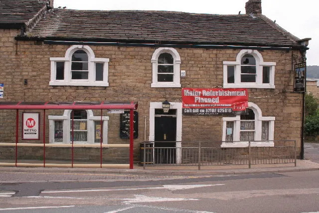
- Postal Code
- HX7 5LH
- Street
- Burnley Road
- Amenity
- pub
- Building Type
- commercial building
- Wheelchair Access
- yes
Bus stops
Roads nearby
West End Terrace50 m
Burnley RoadBurnley Road Midgley Road, Burnley Road Brier Hey Lane, Burnley Road White Lee Gardens, Burnley Road White Lee Terrace, HB3 Burnley Road, HB2 Burnley Road Station Road, Mytholmroyd, Burnley Road New Road, Burnley Road, Burnley Road Bank Buildings, Hawk, Burnley Road Brearley, Burnley Road Moderna Way, Burnley Road Ewood Drive, Hebden Bridge
100 m
Grange Dean Yard100 m
Coiners Wharfe100 m
Church Street150 m
Caldene Bridge150 m
Longfellow Court150 m
Caldene Avenue150 m
Bank View150 m
Westfield Terrace200 m
George StreetMytholmroyd
200 m
Calder Grove200 m
Acre Villas200 m
Thrush Hill Road200 m
Clarendon Street200 m
Erringden Road250 m
Ashton Road250 m
Streamside Fold250 m
New RoadNew Road Railway Station, HB5 New Road, Sam's Pizzas, Hebeden Bridge Ink, Hair And There, The Willow Garden, The Railway, Paradise, Hebden Bridge Dental Care, Vocation, Hebden Townhouse, Crossley Mill Nursery, Gina B Glass, HB7 New Road, HB6 New Road, HB4 New Road, Nightjar, MAMIL
250 m
Royal Fold250 m
Scout RoadScout Road Cragg Road, Scout Road
300 m
Elphaborough Close300 m
St Georges Fold300 m
Stocks Avenue300 m
Thorn Bank350 m
Stubbings Street350 m
Hall Bank Lane350 m
Cragg RoadCragg Road Stocks Lane, Cragg Road, Adventure-Spec
350 m
Scout View400 m
King StreetKing Street, King Street Oakville Road, King Street Church Lane
450 m
Hall Gate450 m
Bars nearby
Barbary's100 m
Buildings nearby
RP90250 m
Cafés nearby
The Blue Teapot100 m
Jo's Kitchen100 m
Convenience stores nearby
Sainsbury's Local50 m
Fire stations nearby
Mytholmroyd Fire Station150 m
Houses nearby
Former Mytholmroyd Police Station and houses.300 m
Places of worship nearby
St. Michael's150 m
Good Shepherd250 m
Mytholmroyd Methodist Church350 m
Post offices nearby
Newsagent and Post Office50 m
Pubs nearby
Shoulder of Mutton250 m
Railway lines nearby
Caldervale Line200 m
Residential buildings nearby
Mytholmroyd Farm.350 m
School buildings nearby
Burnley Road Academy250 m
Sports centres nearby
Mytholmroyd Community & Leisure Centre200 m
Sports pitches nearby
Mytholmroyd Wmc Crown Green Bowls Club300 m
Streams nearby
Elphin Brook250 m
| Heritage designation | Grade II listed building |
|---|---|
| Located in | Hebden Royd |
| Country | United Kingdom |
 Public transport map Hebden Royd Legend
| Railway | |
| Bus | |
| Tram |
 Cycling map Hebden Royd Legend
| Cycle path | |
| Cycle lane on road | |
| Cycling on bus lane | |
| Bicycle street | |
| Cyclists allowed | |
| Cyclists allowed, good surface | |
| No cycling | |
| Cobblestones |
| Long-distance cycle route | (depending on scale) | |
| Long-distance cycle route |
 Walking map Hebden Royd Legend
| Path |
| Long-distance hiking trail | (depending on scale) | |
| Long-distance hiking trail | ||
| No pedestrians |