
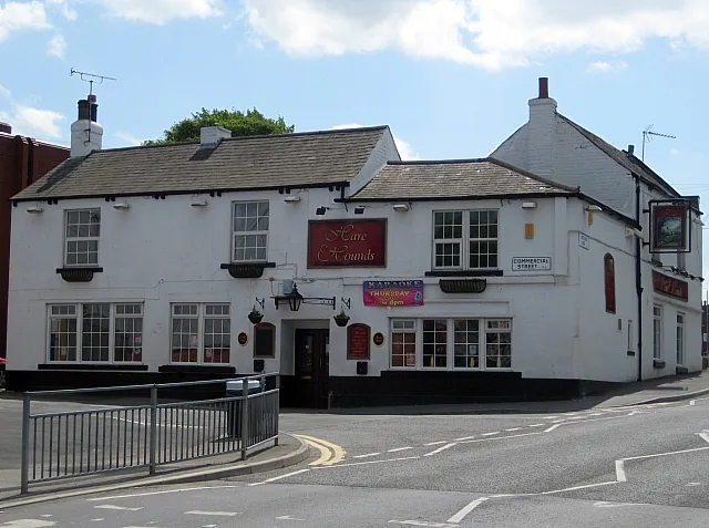
Hare and Hounds Inn in City of Leeds
Hare and Hounds Inn in Leeds is a pub (opening hours: Mo-Th 12:00-23:30, Fr 12:00-00:30, Sa 11:00-00:30, Su 11:00-23:30), Commercial Street (LS26 0QD).
- Postal Code
- LS26 0QD
- Street
- Commercial Street
- Amenity
- pub
- Building Type
- commercial building
Image
Roads nearby
Butcher LaneMcKenzie Barbers, Goodall's Tailors
50 m
Cross StreetRothwell Methodist Church, Leeds
100 m
Cross Terrace100 m
Barraclough Yard150 m
Ingram ParadeIngram Parade Church Street
150 m
Church StreetOwls And Pussycats Playgroup, Londis, Church Street Highfield Lane, Woodlesford Church, Karvanis Pizzas, The Beach, Brown And White, Simply Grilled, The Fun Zone, Calilo, Chana Store, Church Street The Oval, Hunslet District Centre, St Gemmas Hospice, Hunslet, Church Street Grove Road, Paradise Takeaway, The Sun Inn, Church Street Balm Road, Mickys Munch Box, Town Gate Church Street, Welcome Way, Church Street Belinda Street, The New Inn, Wharfedale Autocare
150 m
Lay Garth Close150 m
Mill Hill Square200 m
Mill HillThe Head of Steam, Tharavadu, RAW Coffee, Bundobust, Sacred Electric Tattoo, Eye Room
200 m
Victoria AvenueVictoria Avenue, Victoria Avenue Glenmore Mount, Victoria Avenue Bayton Lane
200 m
Lay Garth Square200 m
Wood LaneHoly Trinity Church, Wood Lane Haighside Drive, Wood Lane St Georges Crescent, Wood Lane, Wood Lane Spibey Lane, Wood Lane Back Haigh Avenue, Wood Lane Haigh Avenue, Wood Lane Low Shops Lane, Wood Lane Rothwell, Wood Lane Wakefield Road, Rothwell Haigh, Shire Oak Primary After School Club, Headingley Pre-School, Wood Lane Manor Road, Wood Lane Pasture View Road, CoffeeBoy, Nando's, Wood Lane The Paddock, Jawbones
200 m
Mill Hill Green250 m
Lay Garth Sport250 m
Lay Garth Glade250 m
Lay Garth250 m
St Clements Avenue250 m
Lay Garth Mead300 m
Lay Garth Fold300 m
Meynell Avenue300 m
The Paddock300 m
Lay Garth Place350 m
Windmill LaneRufford Park, Aldridge Brothers
350 m
Lay Garth Gardens400 m
Armitage Street400 m
Clement Terrace400 m
Lay Garth Green400 m
Talbot Terrace400 m
Pasture View Road400 m
St Clements Rise450 m
Windmill Chase450 m
Manor CrescentWood Lane Estate
450 m
St Clements Close450 m
Carlton LaneCarlton Lane Stainton Lane, Carlton Lane Stone Brig Lane, Carlton Lane, Carlton Lane Victoria Avenue, Carlton Lane End
500 m
Perseverance Terrace500 m
Buildings nearby
Rothwell Telephone Exchange100 m
Allotment gardens nearby
Rothwell Windmill Allotments350 m
Rothwell Carlton Lane Allotments550 m
Convenience stores nearby
Rothwell Local450 m
Dental practices nearby
Rothwell Dental Surgery200 m
Doctor's practice nearby
Rothwell Health Centre150 m
Fire stations nearby
Rothwell Fire Station400 m
Kindergartens nearby
Tina's Tots Nursery150 m
Pharmacies nearby
Boots100 m
Places of worship nearby
Holy Trinity Church200 m
Social facilities nearby
Dolphin Manor300 m
Streams nearby
Rothwell Beck450 m
Supermarkets nearby
Morrisons100 m
Taxi ranks nearby
G&M Taxi100 m
| Located in | Leeds |
|---|---|
| Street | Commercial Street |
| Country | United Kingdom |
| Location | Rothwell |
 Public transport map Leeds Legend
| Railway | |
| Bus | |
| Tram |
 Cycling map Leeds Legend
| Cycle path | |
| Cycle lane on road | |
| Cycling on bus lane | |
| Bicycle street | |
| Cyclists allowed | |
| Cyclists allowed, good surface | |
| No cycling | |
| Cobblestones |
| Long-distance cycle route | (depending on scale) | |
| Long-distance cycle route |
 Walking map Leeds Legend
| Path |
| Long-distance hiking trail | (depending on scale) | |
| Long-distance hiking trail | ||
| No pedestrians |