
Stegeman Coliseum in Athens, Georgia
Stegeman Coliseum in Athens is a stadium (formerly Georgia Coliseum), Smith Street 100 (30602). Stegeman Coliseum is also known as The Steg. Ⓦ.
- House Number
- 100
- Postal Code
- 30602
- Street
- Smith Street
- Building Type
- stadium
- Operator
- University of Georgia
Image
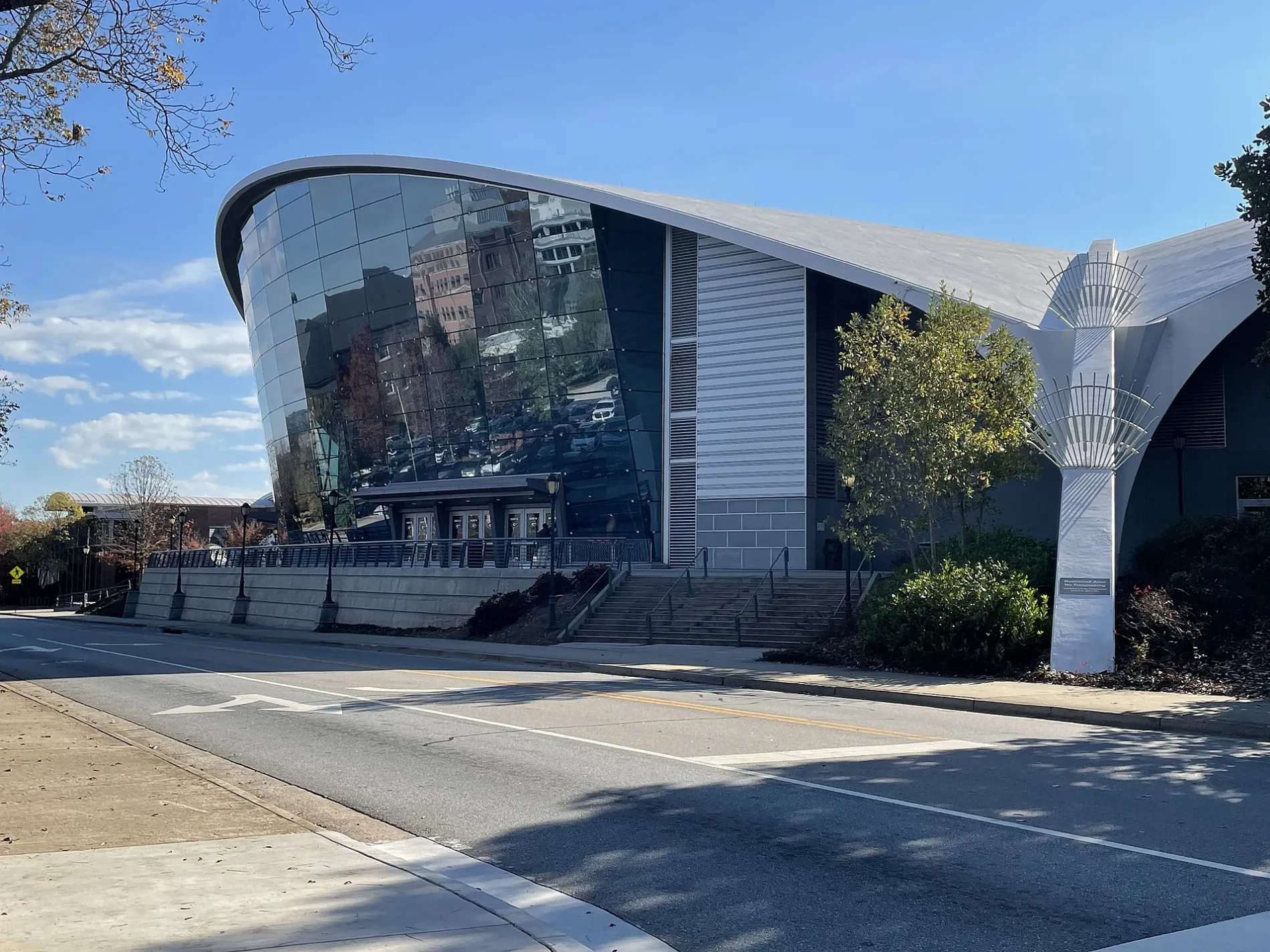
Charging stations
Convenience stores
Florists
Bus stops
Artworks
Fast food restaurants
Taxi stands
Bicycle repair stations
Game stores
Streets nearby
Smith Street400 ft
Carlton StreetStegeman Coliseum, Einstein Bros. Bagels, University Health Center, Aderhold Hall (to Plant Science), Aderhold Hall IB (to Plant Science), Aderhold Hall OB (to East Campus Rd.), Plant Sciences, Joe Frank Harris Commons, Ramsey Center, Science Learning Center, Ellie the Exploration Dawg
0.1 mi
South Lumpkin StreetSouth Lumpkin Street at 2136 South Lumpkin Street Outbound, Birchmore Trail at Memorial Park, Correll Hall, Lumpkin Street at Wray Street, ZZ & Simone's, Five Points, Tyche's Games, Brett Glenn Floral Design, ADD Drug, Animal Eye Care Clinic, Doma, Independent Baking Company, Panache Hair Designs, Suska, LRG Provisions, South Lumpkin Street at West Lake Drive Outbound, South Lumpkin Street at Westview Drive Outbound, Five Points Outbound, J. Christopher’s, Condor Chocolates, Avid Bookshop, Earth Fare, Princeton United Methodist Church Outbound, South Lumpkin Street at Cemetery Outbound, Lumpkin Street @ Rutherford Street (to Five Points), South Lumpkin Street at West Rutherford Street Outbound, Gilbert Hall, Hoke-Smith Annex Inbound, 1250 South Lumpkin Outbound, Presbyterian Center, Mediterranean Grill, Smoothie King, Rutherford Street (Lumpkin to Campus), South Lumpkin Street at Rutherford Street Inbound, Emacity Boutique, Sonder Aesthetica, South Lumpkin at Woodrow Outbound, Billy & Beau's Coffee, South Lumpkin Street at Riverview Outbound, South Lumpkin Street at Old Princeton Road Outbound, Princeton, Baddies
0.1 mi
West Green Street0.2 mi
Soule Street0.3 mi
Sanford DriveSoule Hall, Myers Quad, Snelling Dining Commons, Your Pie, Starbucks, Tate Theater, Memorial Hall, Tate Center, Physics (southbound), Athens Gneiss Drill Core, Physics (to Tate), Geography Handicap Access, Georgia Center
0.3 mi
Dawson Street0.3 mi
Cedar StreetFood Science, Georgia Museum of Natural History, STEM Research, Conner Hall, Map of Campus, Chemistry, Rutherford Hall (to Lumpkin Sreet), Rutherford Hall (to Lumpkin Street), Rutherford Hall (to Sanford Drive)
0.3 mi
Amenities nearby
Alpha Chi Omega0.2 mi
Apartment buildings nearby
The Lyons0.3 mi
Buildings nearby
Treanor House0.2 mi
Cobb House0.2 mi
Dormitories nearby
Mary Lyndon Hall0.2 mi
Myers Hall0.2 mi
Soule Hall0.3 mi
Rutherford Hall0.3 mi
Fast food restaurants nearby
Snelling Dining Commons0.2 mi
Gardens nearby
UGA Trial Gardens0.2 mi
D.W. Brooks Connect to Protect Garden0.2 mi
Houses nearby
Auxiliary Services0.2 mi
Libraries nearby
Shirley Mathis McBay Science Library0.3 mi
Parking lots nearby
South Campus Parking Deck0.2 mi
Parks nearby
Alan Jaworski Plant Science Amphitheater0.2 mi
D.W. Brooks Mall0.3 mi
Myers Quad0.3 mi
Places of worship nearby
Wesley Foundation0.2 mi
Single-family houses nearby
Housing and Consumer Research Center0.1 mi
Financial Planning Research Center0.1 mi
Family Science Center 20.1 mi
Family Science Center 10.1 mi
Sports fields nearby
Woodruff Field350 ft
University buildings nearby
Hoke Smith Annex250 ft
Hoke Smith Cooperative Extension Building0.1 mi
Science Learning Center0.1 mi
Child Development Laboratory0.1 mi
Pharmacy South0.2 mi
Wilson Pharmacy Building0.2 mi
Marine Science Building0.2 mi
Forest Resources 40.2 mi
Forest Resources 10.2 mi
Environmental Health Sciences0.2 mi
Physical Education Building0.3 mi
Forest Resources 20.3 mi
Forest Resources 30.3 mi
Hardman Hall0.3 mi
Boyd Graduate Research Center0.3 mi
Dawson Hall0.3 mi
Speirs Hall0.3 mi
Waters nearby
Mary Kahrs Warnell Memorial Garden and Pond0.3 mi
| Year built | 1960 |
|---|---|
| Official opening | 1964 |
| Located in | Athens |
| Country | United States |
 Public transit map Athens Legend
| Railway | |
| Bus | |
| Streetcar |
 Bicycle map Athens Legend
| Bike path | |
| Bike lane on roadway | |
| Cycling allowed on bus lane | |
| Bicycle street | |
| Open to cyclists | |
| Open to cyclists, good path | |
| Cycling prohibited | |
| Cobblestone |
| Long-distance bike route | (depending on scale) | |
| Long-distance bike route |
 Pedestrian map Athens Legend
| Path |
| Long-distance hiking trail | (depending on scale) | |
| Long-distance hiking trail | ||
| Pedestrians prohibited |