
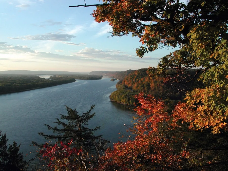
Mississippi River in Downtown, Saint Paul, Minnesota
Mississippi River in Saint Paul is a river. Mississippi River is also known as The Mississippi. Mississippi River also exists in Dayton's Bluff, West Side, Highland and Macalester - Groveland. Ⓦ.
- Waterway Type
- river
Bus stops
Cafes
Stations
Restaurants
Theaters
Hotels
Light rail stops
Fast food restaurants
Courthouses
Bookstores
Libraries
Artworks
Streets nearby
Shepard Road350 ft
Kellogg Boulevard WestCourtyard, Summit Av, Mulberry St
550 ft
Wabasha Street North4 St, 10 St, 5 St / 6 St - Arrive, Erbert & Gerbert's, 7 St, Exchange St, Wabasha7 Market, Walgreens, The Pillbox Tavern
550 ft
East 2nd Street0.1 mi
4th Street West0.2 mi
4th Street EastCedar St / Wabasha, Subway, The Baroque Room, Lowertown Wine & Spirits, Master Framers, Union Depot, Lost Fox, SimplyFaded Barbershop, Weeziez, Urban Wok, Central Station
0.2 mi
Minnesota Street4 St, Minnesota St & 6th St, Rival House Sporting Parlour, Minnesota St & 9th St, Minnesota St & 7th St
0.2 mi
Harriet Island Boulevard0.2 mi
Wabasha Street SouthWater W (Fillmore), Starbucks, Congress St, Winifred St, Concord St, Fillmore (Water W), Torre De San Miguel, #216, Joseph's Grille, Plato Blvd
0.2 mi
Kellogg Boulevard EastMinnesota St, Union Depot, Union Depot & Gate A1, Gate A3, Gate A4, Gate A5, Jefferson Lines - Union Depot, Union Depot Station & Terminal, Choo Choo Bob's Train Store, Hyatt Place St. Paul/Downtown, Kellogg Boulevard & Broadway Street, Gate A2, Hertz
0.3 mi
Robert Street NorthRobert Street, 6 St, 6 St / 5 St, 6 St / 5 St - Arrive, 7 Place, Keys Cafe, 9 St, 11 St, Camp, Caribou Coffee, Downtown, ChargePoint, Robert Street & Kellogg Boulevard
0.3 mi
Ecolab PlazaSkygate
0.3 mi
5th Street East5th Street & Minnesota Street, 5th Street & Cedar Street, 5th Street & Jackson Street, Hat Trick Lounge, A & T Market, 5th Street & Robert Station, 5th Street & Wacouta Street, Lowertown, 5th Street & Cedar Station, Saint Dinette, Big River Pizza
0.3 mi
Livingston Avenue0.3 mi
Capital City BikewayHOURCAR, Union Depot Lot A, Jimmy John's, Saint Paul City Hall and Courthouse, Ruam Mit, Candyland, Amsterdam Bar & Hall, Focus Optical
0.4 mi
Jackson StreetMain South Parking Ramp, 12 St, 14 St
0.4 mi
Apartment buildings nearby
West Side Flats0.2 mi
Kellogg Square0.3 mi
Pioneer Building0.3 mi
Endicott on 4th0.3 mi
Custom House0.4 mi
Bandstands nearby
Schubert Club Bandshell0.1 mi
Buildings nearby
Degree of Honor Building0.2 mi
YMCA Best Buy Teen Tech Center0.2 mi
Minnesota Building0.2 mi
Pioneer Press0.2 mi
Saint Paul Athletic Club0.2 mi
North Building0.3 mi
US Bank0.3 mi
Ramsey County Government Center East0.3 mi
Empire Building 3600.3 mi
Endicott Arcade0.4 mi
375 Jackson0.4 mi
Courthouses nearby
Warren E. Berger Federal Building & US Courthouse0.3 mi
Event venues nearby
Minnesota Boat Club300 ft
Hotels nearby
InterContinental Saint Paul Riverfront0.1 mi
Office buildings nearby
First National Bank Building0.3 mi
Merchants Bank Building0.3 mi
Parking lots nearby
Capital City Plaza Parking Ramp0.2 mi
Victory Ramp0.2 mi
US Bank Building0.4 mi
Jackson Street Ramp0.4 mi
Parks nearby
Raspberry Island0.2 mi
Kellogg Mall Park0.3 mi
Culture Park0.3 mi
Railways nearby
Merriam Park Subdivision0.2 mi
UP Albert Lea Subdivision0.3 mi
School buildings nearby
Creative Arts Secondary0.2 mi
Town halls nearby
Saint Paul City Hall0.2 mi
| Length | 3766 |
|---|---|
| Located in | United States |
| Country | United States |
| Source | Lake Itasca |
| Mouth | Gulf of Mexico |
| Tributary | Black River, Arkansas River, Ohio River, Saint Croix River, Wisconsin River, Rock River, Illinois River, Kaskaskia River, Minnesota River, Des Moines River, White River, Apple River, Big Muddy River, St. Francis River, Yazoo River, Big Black River, Maquoketa River, Wolf River, Rice Creek, Iowa River, Turkey River, Loosahatchie River, Meramec River, Wapsipinicon River, Chippewa River, River des Peres, Bayou Pierre, Catfish Creek, Crow River, Duck Creek, Hatchie River, Henderson Creek, Little Maquoketa River, Marys River, Obion River, Prairie River, Rum River, Rush River, Salt River, Schoolcraft River, Skunk River, Swan River, Trempealeau River, Turtle River, Upper Iowa River, Vermillion River, Wind River, Yellow River, Village Creek, Brazeau Creek, Cinque Hommes Creek, Nokasippi River, Apple Creek, Coles Creek, River aux Vases, Minnehaha Creek, Fox River, Bassett Creek, Sucker Creek, Missouri River |
| Native name | Mississippi River |
| Described by | Sytin Military Encyclopedia, Small Brockhaus and Efron Encyclopedic Dictionary, Brockhaus and Efron Encyclopedic Dictionary, Jewish Encyclopedia of Brockhaus and Efron, The Nuttall Encyclopædia, Great Soviet Encyclopedia (1926–1947), The Encyclopedia Americana, The American Cyclopædia, Encyclopædia Britannica 11th edition, Collier's New Encyclopedia, 1921, The New Student's Reference Work, New International Encyclopedia, Meyer’s Universum, Fünfzehnter Band, Meyer’s Universum, Siebzehnter Band, Meyer’s Universum, Achtzehnter Band, Granat Encyclopedic Dictionary |
 Public transit map Downtown Legend
| Railway | |
| Bus | |
| Streetcar |
 Bicycle map Downtown Legend
| Bike path | |
| Bike lane on roadway | |
| Cycling allowed on bus lane | |
| Bicycle street | |
| Open to cyclists | |
| Open to cyclists, good path | |
| Cycling prohibited | |
| Cobblestone |
| Long-distance bike route | (depending on scale) | |
| Long-distance bike route |
 Pedestrian map Downtown Legend
| Path |
| Long-distance hiking trail | (depending on scale) | |
| Long-distance hiking trail | ||
| Pedestrians prohibited |