
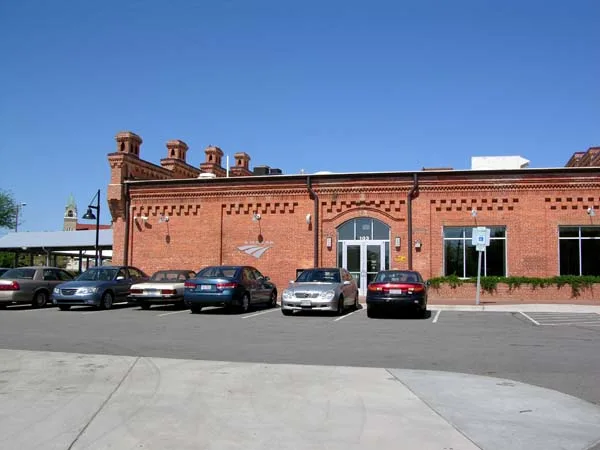
Durham Station in Durham, North Carolina
Durham Station in Durham is a train station, West Main Street 601 (27701). Ⓦ.
- House Number
- 601
- Postal Code
- 27701
- Street
- West Main Street
- Building Type
- train station
- Website
- https://www.amtrak.com/stations/dnc
Image
Streets nearby
South Great Jones Street350 ft
Ramseur Street550 ft
Willard StreetWillard St at Jackson St (American Tobacco Campus), Willard St at Yancey St (Ramada Inn)
0.1 mi
Fuller Street0.1 mi
West Chapel Hill StreetChapel Hill St at Brewster St, Duke University Rd at Chapel Hill Rd, Durham, Chapel Hill St at Gregson St (EB), Chapel Hill St at Main St, Chapel Hill St at Duke St (Durham Police Dept), Chapel Hill St at Gregson St (WB), Chapel Hill St at Kent St (EB), Joe van Gogh, Local Yogurt, Durham Co Op, Chapel Hill St at Carroll St, LR Custom Fabrication
0.1 mi
West Peabody StreetJackie Moore Salon, Schoolkids Records, Hamilton Hill, James Kennedy Antiques
0.1 mi
Jackson StreetWhetstone Apartments
0.2 mi
Memorial Street0.2 mi
Julian Carr Street0.2 mi
Burch Avenue0.2 mi
West Pettigrew StreetMichael Jordan Nissan Collision Center, Ambacco Fountain, Pettigrew St at Mangum St (EB), Durham Station, Pettigrew St at Mangum St (WB)
0.2 mi
South Gregson StreetEl Rodeo, SunTrust, Vert and Vogue, Morgan Imports, Gregson St at Main St (Brightleaf Square)
0.2 mi
Gordon Street0.3 mi
Vickers Avenue0.3 mi
South Duke StreetDuke St at Cobb St, Durham, Duke St at Morehead Ave (Henderson Towers), Duke St at Jackson St
0.3 mi
William Vickers Avenue0.3 mi
Durham Freeway0.3 mi
Morehead AvenueMorehead Ave at Duke St (EB), Morehead Ave at Duke St (WB), Morehead Hill, Morehead Ave at Fairview St, Morehead Ave at Carroll St (EB), Morehead Ave at Cornell St, Morehead Ave at Vickers Ave (EB), Morehead Ave at Kent St, Morehead Ave at Carroll St (WB), Morehead Ave at Arnette Ave (WB), Morehead Ave at Arnette Ave (EB), Morehead Ave at Vickers Ave (WB), West End, Morehead Ave at Moreland Ave
0.4 mi
Parker Street0.4 mi
Yancey StreetTruist
0.4 mi
Amenities nearby
Research Square150 ft
Abandoned railways nearby
Durham Beltline450 ft
Apartment buildings nearby
West Village0.1 mi
Willard Street Apartments0.1 mi
Ashton Place0.1 mi
605 West End Apartments0.3 mi
Attractions nearby
11-foot-8 Bridge0.2 mi
Banks nearby
North Carolina State Employee Credit Union0.2 mi
Bars nearby
West End Wine Bar200 ft
Buildings nearby
West Villiage450 ft
Chesterfield Building0.1 mi
Old Durham Police Headquarters0.2 mi
Lucky Strike Water Tower0.3 mi
Construction sites nearby
The Novus0.1 mi
The Grove0.3 mi
Furniture stores nearby
Durham Bookcases & Other Cool Wood Stuff250 ft
Guest houses nearby
Greystone Inn and Conference Center0.5 mi
Industrial buildings nearby
Power Plant0.3 mi
Museums nearby
The History Hub Museum550 ft
Office buildings nearby
N.C. Mutual Life Building0.1 mi
Parking lots nearby
North Parking Deck0.2 mi
South Parking Deck0.4 mi
Places of worship nearby
Duke Memorial United Methodist Church0.2 mi
Pubs nearby
Bull McCabe's Irish Pub500 ft
Railways nearby
NS Danville District H Line150 ft
Restaurants nearby
Mateo0.1 mi
Retail buildings nearby
Washington Building0.3 mi
Shopping malls nearby
Brightleaf Square0.2 mi
Stations nearby
Durham Station Transportation Center300 ft
| Year built | 2009 |
|---|---|
| Official opening | 2009 |
| Located in | North Carolina |
| Country | United States |
 Public transit map Durham Legend
| Railway | |
| Bus | |
| Streetcar |
 Bicycle map Durham Legend
| Bike path | |
| Bike lane on roadway | |
| Cycling allowed on bus lane | |
| Bicycle street | |
| Open to cyclists | |
| Open to cyclists, good path | |
| Cycling prohibited | |
| Cobblestone |
| Long-distance bike route | (depending on scale) | |
| Long-distance bike route |
 Pedestrian map Durham Legend
| Path |
| Long-distance hiking trail | (depending on scale) | |
| Long-distance hiking trail | ||
| Pedestrians prohibited |