
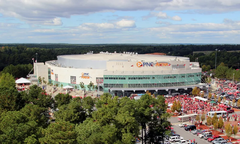
Lenovo Center in Raleigh, North Carolina
Lenovo Center in Raleigh is a stadium (formerly PNC Arena), Edwards Mill Road 1400 (27607). Lenovo Center is also known as RBC Center. Ⓦ.
- House Number
- 1400
- Postal Code
- 27607
- Street
- Edwards Mill Road
- Building Type
- stadium
- Website
- https://www.lenovocenter.com
Image
Fast food restaurants
Schools
Places of worship
Bus stops
Restaurants
Convenience stores
Gas stations
Tourist information centers
Streets nearby
E. Stephen Stroud Way0.2 mi
Donnie Mac Way0.2 mi
Westchase Boulevard0.2 mi
Loblolly TrailA Cord of Wood, Why do we Thin?
0.2 mi
Richland Creek TrailNatural Area/ Protected Watershed
0.2 mi
Trinity RoadTrinity Rd at Blue Ridge Rd
0.3 mi
Edwards Mill RoadEdwards Mill Rd at Wade Park Blvd (SB), Edwards Mill Rd at Mill Village Rd, Edwards Mill Rd at Glen Laurel Dr (Stough Elementary School), Edwards Mill Rd at Reedy Creek Rd (SB), Edwards Mill Rd at Arckelton Dr, Edwards Mill Rd at Crabtree Valley Ave, Edwards Mill Rd at Sunrise Senior Center, The UPS Store, Stromboli's, Edwards Mill Rd at Carriage Dr (SB), Edwards Mill Rd at Carriage Dr (Laurel Hills Park), Edwards Mill Rd at Parklake Ave (SB), Edwards Mill Rd at Parklake Ave (NB), Edwards Mill Rd at Kingdom Way, Edwards Mill Rd at Reedy Creek Rd (NB), Edwards Mill Rd at Wade Park Blvd (NB), Edwards Mill Rd at Trinity Rd (NB), Edwards Mill Rd at Trinity Rd (Cardinal Gibbons HS), Edwards Mill Rd at John Humphries Wynd, Edwards Mill Rd at Ed Dr, Char-Grill, Edwards Mill Rd at Laurel Hills Rd (north), Wells Fargo, Edwards Mill Rd at Glen Eden Dr (NB), Edwards Mill Rd at Glen Eden Dr (SB), Mount Olivet Baptist Church, Edwards Mill Rd at Blueberry St, Edwards Mill Rd at Laurel Hills Rd (south)
0.3 mi
Peter Karmanos Jr Drive0.3 mi
Hurricane Alley WayBackyard Bistro
0.4 mi
Wade Park BoulevardWade
0.4 mi
Wade AvenueBruegger's Bagels, Wade Ave at Ridge Rd (Meredith College), Unitarian Universalist Fellowship of Raleigh, Wade Ave at Faircloth St, Wade Ave at Dogwood Ln, Community United Church of Christ
0.4 mi
Kingdom Way0.5 mi
Raleigh School Drive0.5 mi
Youth Center Drive0.5 mi
Arete Way0.6 mi
Corinthian Way0.6 mi
Garnet Ridge Way0.6 mi
Grand Avenue0.6 mi
Lake Moraine Place0.6 mi
Heritage Circle0.6 mi
Gold Star Drive0.6 mi
District Drive0.6 mi
Creekside Ridge Avenue0.6 mi
Oglethorpe Avenue0.7 mi
Merritt Street0.7 mi
Gary Street0.7 mi
Buildings nearby
Hunt Horse Complex covered arena0.4 mi
Buildings nearby
Football Practice Facility0.4 mi
North Carolina State Laboratory of Public Health0.4 mi
Heritage Church0.6 mi
Governor James E. Holshouser Building0.7 mi
Cemeteries nearby
Lincolnville AME Church Cemetery0.2 mi
Cemetery 20.3 mi
Convenience stores nearby
Breeze Thru0.4 mi
Equestrian centers nearby
James B. Hunt Horse Complex0.4 mi
Fast food restaurants nearby
Wendy's0.4 mi
Gas stations nearby
760.4 mi
Hotels nearby
Four Points by Sheraton Raleigh Arena0.4 mi
Recreation grounds nearby
North Carolina State Fairgrounds0.6 mi
Residential areas nearby
The Station Apartments0.6 mi
Sports fields nearby
Wayne T. Day Family Field0.2 mi
Stadiums nearby
Carter-Finley Stadium0.3 mi
Streams nearby
Richland Creek0.3 mi
University buildings nearby
Murphy Football Center0.3 mi
Close-King Indoor Practice0.4 mi
Warehouses nearby
N.C. State Fair Warehouse0.7 mi
Other nearby
Trinity Square0.6 mi
Gate 60.6 mi
Gate 50.7 mi
| Named after | PNC Financial Services, Lenovo, Royal Bank of Canada |
|---|---|
| Year built | 1999 |
| Official opening | 1999 |
| Operator | Carolina Hurricanes |
| Located in | Raleigh, North Carolina |
| Country | United States |
 Public transit map Raleigh Legend
| Railway | |
| Bus | |
| Streetcar |
 Bicycle map Raleigh Legend
| Bike path | |
| Bike lane on roadway | |
| Cycling allowed on bus lane | |
| Bicycle street | |
| Open to cyclists | |
| Open to cyclists, good path | |
| Cycling prohibited | |
| Cobblestone |
| Long-distance bike route | (depending on scale) | |
| Long-distance bike route |
 Pedestrian map Raleigh Legend
| Path |
| Long-distance hiking trail | (depending on scale) | |
| Long-distance hiking trail | ||
| Pedestrians prohibited |