
South Main Street in Tulsa, Oklahoma
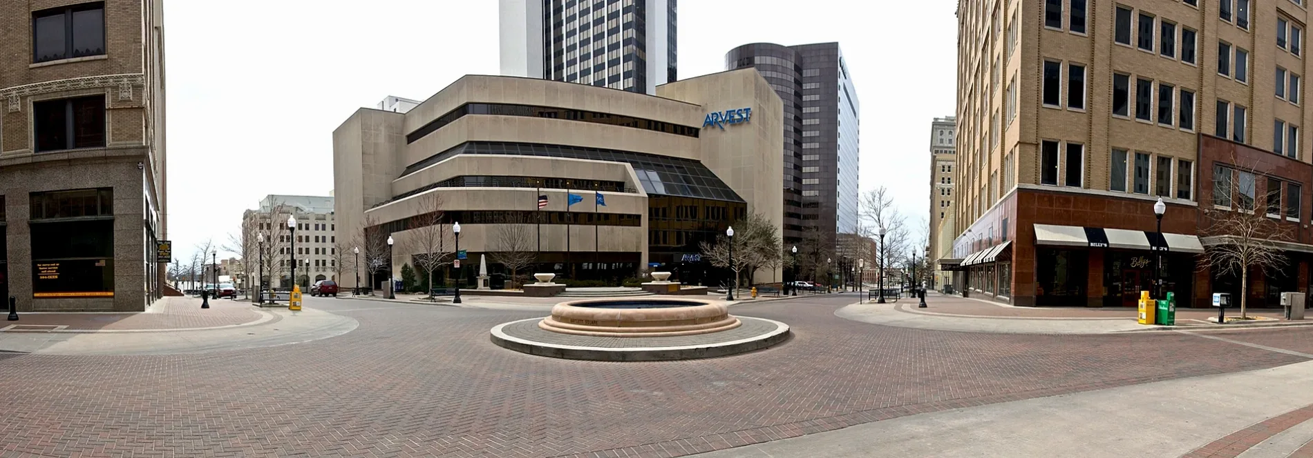
South Main Street in Tulsa is a paving-stones footpath. It runs in a southeast-northwest direction starting from East 3rd Street South and crosses West 3rd Street South, East 4th Street and West 4th Street South and ends at Bartlett Square. This street is part of the Bicycle route "Main Street Linkage". Nearby you can find among others 3 fast food restaurants, a music school, a beauty salon and a doctor's office. The nearest bus stop is 3rd Street & Main Street (about 0 m away). South Main Street also exists in Owasso, Broken Arrow, Bixby and Sand Springs.
- Bicycle
- designated
- Road Type
- local road
- Speed Limit
- 25 mph
- Route
- southeast-northwest
Fast food restaurants
Convenience stores
Police stations
Bus stops
- bus lines 900
Music schools
Beauty salons
Doctor's offices
Vacation apartments
Bars
Coffee shops
Streets nearby
East 3rd Street South3rd Street & Main Street, The Avery, 3rd Street & Rockford Avenue, 3rd Street & Utica Avenue, (8880) 3RD ST. & PEORIA AVE. WB, (7610) S Cincinnati Ave & E 3rd St S EB
150 ft
East 4th Street4th Street & Norfolk Avenue, Shear Perfection Hair Design, Bank of Oklahoma, Chase
350 ft
Bartlett Square0.1 mi
South Cincinnati AvenueTulsa City Hall, Cincinnatti Avenue & 8th Street, Cincinnatti Avenue & 6th Street, Cincinnatti Avenue & 5th Street, Chamber Restaurant, Bank of America, Coracle Coffee, Who's Truth TV & Productions, Bonray Barber, The Temple Studio, Episcopal Diocese of Oklahoma
0.2 mi
East 6th StreetIBM, Bonston Title & Abstract
0.2 mi
West 2nd Street South(7171) 2nd St & Denver Ave EB, Kickers, (7363) 2nd St & CHEYENNE Ave EB
0.2 mi
East 7th StreetPlain View Heights
0.3 mi
Apartment buildings nearby
Excaliber Building300 ft
Reunion Center350 ft
Mayo Building0.1 mi
Vandever's Building0.2 mi
Sinclair Building0.2 mi
Enterprise Building0.2 mi
ARCO Apartments0.2 mi
Banks nearby
Arvest0.2 mi
Bars nearby
Shady Keys0.3 mi
Buildings nearby
Pythian Building0.1 mi
Philtower0.2 mi
Pierce Block0.2 mi
First Baptist Caring Center0.2 mi
Commercial buildings nearby
Thompson Building0.2 mi
Hotels nearby
Hyatt Place Tulsa / Downtown0.1 mi
Atlas Life Building0.2 mi
Tulsa Club0.2 mi
Office buildings nearby
Parker Building150 ft
Holarud Building150 ft
Renberg's250 ft
Kennedy Building0.1 mi
ONEGas Tower0.1 mi
McFarlin Building0.1 mi
Mid-Continent Tower0.1 mi
Old City Hall0.2 mi
IBM0.2 mi
Center for Architecture & Design0.3 mi
AT&T0.3 mi
Parking lots nearby
Fourth Street Parking0.1 mi
Secure Parking USA0.2 mi
The Birdcage0.3 mi
Parks nearby
Williams Center Green0.1 mi
H.A. Chapman Centennial Green0.3 mi
Places of worship nearby
First Baptist Church0.2 mi
Trinity Episcopal0.2 mi
Pubs nearby
Fassler Hall0.3 mi
Restaurants nearby
The Brook Restaurant and Bar0.2 mi
The Vault0.3 mi
Specialty stores nearby
H&M0.3 mi
Stations nearby
Greyhound0.3 mi
Theaters nearby
Tulsa Performing Arts Center0.1 mi
Other nearby
Blue Dome District0.2 mi
 Public transit map Tulsa Legend
| Railway | |
| Bus | |
| Streetcar |
 Bicycle map Tulsa Legend
| Bike path | |
| Bike lane on roadway | |
| Cycling allowed on bus lane | |
| Bicycle street | |
| Open to cyclists | |
| Open to cyclists, good path | |
| Cycling prohibited | |
| Cobblestone |
| Long-distance bike route | (depending on scale) | |
| Long-distance bike route |
 Pedestrian map Tulsa Legend
| Path |
| Long-distance hiking trail | (depending on scale) | |
| Long-distance hiking trail | ||
| Pedestrians prohibited |