
Baitul Hamd in City of Bradford
Baitul Hamd in Bradford is a mosque, Leeds Road 393 (BD3 9LY). It is also known as Baitul Hamd Mosque and was built in 1980. Ⓦ.
- House Number
- 393
- Postal Code
- BD3 9LY
- Street
- Leeds Road
- Alternative Name
- Baitul Hamd Mosque
- Amenity
- place of worship
- Building Type
- building
Image
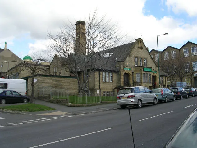
Roads nearby
Leeds RoadSalvation Army worship and community hall, Leeds Road Waterloo Pub, Leeds Road Myrtle Street, Leeds Road Walnut Street, Leeds Road Lapage Street, Leeds Road Manse Street, Leeds Road Seymour Street, Leeds Road Allan Street, Leeds Road Cracoe Road, Leeds Road Gladstone Street, Little Germany W, Leeds Road Carroll Street, Leeds Road Carnegie Drive, Great Northern Junction, Leeds Road Marlborough Road, Leeds Road Fourlands Drive, Leeds Road Mitchell Lane, Leeds Road Ashfield Place, Leeds Road Park Road, Thackley Corner, Prince of Wales, Wellington Hotel, Undercliffe, Leeds Road Fagley Drive, Leeds Road George Street, Little Germany X, Leeds Road E, Leeds Road Bradford Lane, Leeds Road Thornbury Street, Leeds Road Loxton Lighting, Leeds Road Wensleydale Road, Leeds Road Flexiform, Thornbury, Leeds Road Thornbury Avenue, Leeds Road Marsland Place, Zouk Tea Bar & Grill, Leeds Road, Leeds Road Pianesar Motors, Costcutter, Busy Lane Post Office, Busy Lane Convenience Store, Leeds Road West Royd Avenue, Charlie's Supersave, Thackley Pharmacy, Natural Beauty Studios, Leeds Road Aire Street, Leeds Road Baddeley Gardens, Leeds Road Cyprus Drive, Leeds Road Cyprus Avenue, Leeds Road Cherry Tree Gardens, Leeds Road Overdale Drive, Leeds Road Cote Farm Lane, Leeds Road Glenholme, Leeds Road Dale Grove, Leeds Road Glenside Avenue, Leeds Road Busy Lane, Leeds Road Daleside Road, Leeds Road Wrose Brow Road, Leeds Road Thackley Old Road, S & H Carpets, Banjo's Cafe, Adante, Sweet Tooth Desserts, Pizza Nonna, Hungry Monkey, Beatz and Pointe Dancewear, CUBE Barbers, Leeds Old Road C, Leeds Road Moorside Place
50 m
Upper Nidd Street50 m
Steadman Terrace50 m
Nidd Street50 m
Cracoe Road100 m
Steadman Street100 m
Hubert Street100 m
Sewell Road150 m
Kilnsey RoadLeeds Road Steadman Street
150 m
Whitehead Street150 m
Joba Avenue150 m
Myrtle Street150 m
Abaseen Close150 m
Gibson Street200 m
Gledhill Road200 m
Amberley Street200 m
Heath Terrace250 m
Laurel Street250 m
Netherby Street250 m
Birksland Street250 m
Walnut Street300 m
Lapage Terrace300 m
Burnsall Road350 m
Bower Green350 m
Almond Street350 m
Greenhill Street350 m
Heath Street350 m
Harewood StreetHarewood Street Bakerend Road
400 m
Orange Street400 m
Kimberley Street400 m
Rufford Street450 m
Pearson Street450 m
Fitzroy Road450 m
Folkestone Street450 m
Hazelhurst Court450 m
Gladstone Street450 m
Sandford Road550 m
Curzon Road550 m
Abandoned railways nearby
Dudley Hill Branch450 m
Allotment gardens nearby
Harewood Street Allotments350 m
Fire stations nearby
Bradford Fire Station (B.40)250 m
Parks nearby
Attock Park400 m
Places of worship nearby
Ghausia Mehria100 m
Abu Bakar Masjid150 m
Jami'ah-tul-Madinah250 m
Faizan e Madina Masjid250 m
Railway lines nearby
Leeds and Bradford Exchange Line350 m
Residential areas nearby
bd3350 m
Social facilities nearby
Marie Curie Hospice300 m
| Inception | 1980 |
|---|---|
| Country | United Kingdom |
 Public transport map Bradford Legend
| Railway | |
| Bus | |
| Tram |
 Cycling map Bradford Legend
| Cycle path | |
| Cycle lane on road | |
| Cycling on bus lane | |
| Bicycle street | |
| Cyclists allowed | |
| Cyclists allowed, good surface | |
| No cycling | |
| Cobblestones |
| Long-distance cycle route | (depending on scale) | |
| Long-distance cycle route |
 Walking map Bradford Legend
| Path |
| Long-distance hiking trail | (depending on scale) | |
| Long-distance hiking trail | ||
| No pedestrians |