
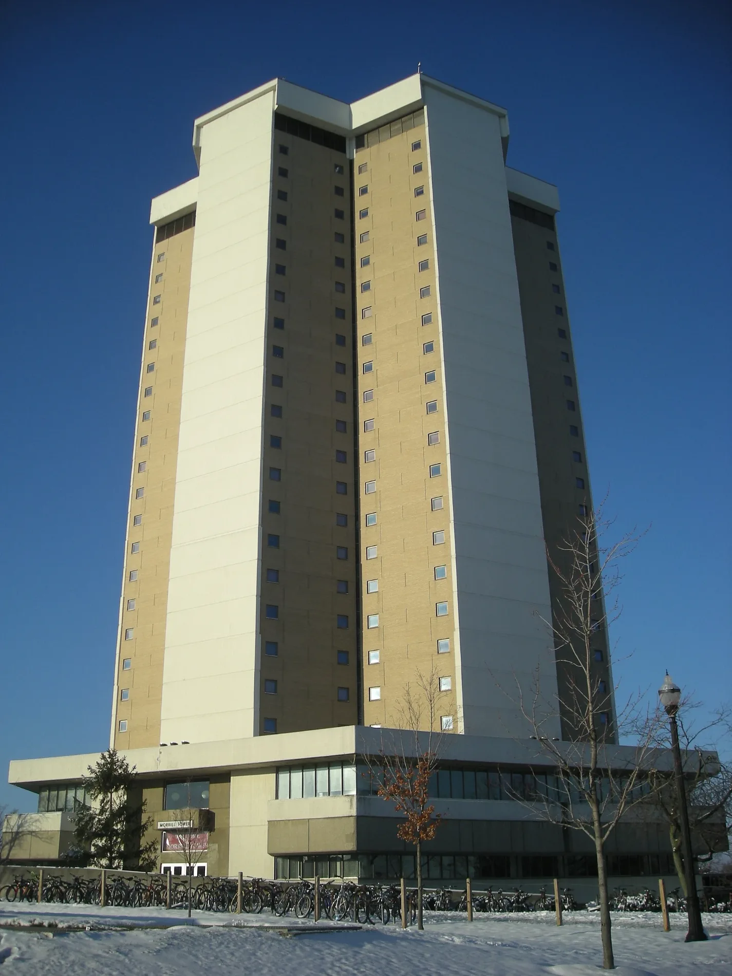
Morrill Tower in Columbus, Ohio
Morrill Tower in Columbus is a dormitory, Cannon Drive 1900 (43210). Morrill Tower is located near Coffey Road. Ⓦ.
- House Number
- 1900
- Postal Code
- 43210
- Street
- Cannon Drive
- Building Type
- dormitory
Image
Cafes
Convenience stores
Music schools
Pharmacies
Bus stops
Bike shops
Libraries
Artworks
Restaurants
ATMs
Veterinary clinics
Streets nearby
Cannon DriveTraditions at Morrill, Morrill C-Store, Mid Towers (Northbound), Mid Towers (Southbound)
450 ft
Olentangy River RoadMount Air, 2200 Olentangy River Rd, Olentangy River Rd & W Lane Ave, Olentangy River Rd & Riverview Rd, Olentangy River Rd & Olde Towne Ave, Olentangy River Rd & Bethel Rd, 3420 Olentangy River Rd, 3368 Olentangy River Rd, 2825 Olentangy River Rd, Olentangy River Rd & Dodridge St, Olentangy River Rd & Argyll St, 3440 Olentangy River Rd, Olentangy River Rd & Union Cemetery, Olentangy River Rd & Ackerman Rd, 315 North, Olentangy River Rd & Harley Dr, Cap City Fine Diner & Bar, Olentangy Medical Center, Riverview Health & Rehabilitation Center, Friendship Community Church, Havener Eye and Ear Clinic, Olentangy River Rd & Burnbrae Ave, Woody Hayes Athletic Center
0.2 mi
Scarlet SkywayCelebration Drum Circle, (M)Body
0.2 mi
Tuttle Park PlaceSteinbrenner Band Center, RPAC Plaza, Bistro 2110, Hot Dog Wally's, KSA Café, Columns
0.2 mi
Annie & John Glenn AvenueUniversity Hall, Museum of Classical Archaeology, University Museum
0.2 mi
Coffey Road0.3 mi
Woody Hayes DriveSt. John Arena (Westbound), St. John Arena (Eastbound), Uranus, Neptune, Midwest Campus (Eastbound), Midwest Campus (Westbound), Pluto, Blankenship Hall, Carmenton
0.3 mi
Vernon L Tharp Street0.3 mi
Kinnear Road1218 Kinnear Rd, 1197 Kinnear Rd
0.3 mi
John H Herrick DrivePenultimate Curving Pavilion, Brenen’s Cafe, Biological Sciences and Pharmacy Library, Herrick Drive Transit Hub
0.3 mi
Olentangy Freeway0.4 mi
Fyffe Court0.4 mi
Olentangy TrailCoyle Memorial Bench
0.4 mi
West Lane AvenueW Lane Ave & Olentangy River Rd, W Lane Ave & Neil Ave, Subway, Side Piece Pies, The Victory Lap, W Lane Ave & Tuttle Park Pl, Rush Bowls, Cuppa Cha, CoGo Lane Ave at Olentangy Trail, Woody Hayes, W Lane Ave & N High St, Daydreamer Coffee
0.4 mi
Fyffe Road0.4 mi
Buildings nearby
Women's Field House0.2 mi
Coffey Rd Recreation Complex0.2 mi
Maintenance Building0.3 mi
Goss Laboratory0.3 mi
Kottman Hall0.3 mi
Ornamental Plant Germplasm Center0.3 mi
Plumb Hall0.3 mi
Howlett Greenhouse0.4 mi
Equine Arena0.4 mi
Howlett Hall0.4 mi
Parker Food Science and Technology Building0.4 mi
Animal Science Building0.4 mi
Agricultural Administration Building0.4 mi
Buildings under construction nearby
Combined Heat and Power Plant0.4 mi
Dormitories nearby
Lincoln Tower0.1 mi
Parking lots nearby
Tuttle Park Place Garage0.3 mi
Parks nearby
Buckeye Grove350 ft
Jesse Owens Plaza0.3 mi
Chadwick Arboretum Lane Ave. Gardens0.3 mi
Chadwick Arboretum Learning Gardens0.4 mi
Recreation grounds nearby
Coffey Road Sports Center0.2 mi
Rivers nearby
Olentangy River550 ft
Service buildings nearby
Smith Electrical Substation0.3 mi
Sports centers nearby
Recreation & Physical Activity Center0.2 mi
Sports fields nearby
Safelite Field0.1 mi
Lincoln Tower Park0.2 mi
Stadiums nearby
Ohio Stadium0.2 mi
Saint John Arena0.4 mi
University buildings nearby
Sisson Hall0.2 mi
Veterinary Medicine Academic Building0.3 mi
French Field House0.4 mi
Agricultural Engineering Building0.4 mi
Veterinary clinics nearby
Frank Stanton Veterinary Spectrum of Care Clinic0.2 mi
OSU Veterinary Medical Center0.3 mi
| Year built | 1967 |
|---|---|
| Commissioned by | Ohio State University |
| Floors above ground | 26 |
| Owned by | Ohio State University |
| Located in | Ohio |
| Country | United States |
| Website | http://www.osu.edu/map/building.php?building=271 |
 Public transit map Columbus Legend
 | Railway | |
| Bus | |
| Streetcar |
 Bicycle map Columbus Legend
 | Bike path | |
| Bike lane on roadway | |
| Cycling allowed on bus lane | |
| Bicycle street | |
| Open to cyclists | |
| Open to cyclists, good path | |
| Cycling prohibited | |
| Cobblestone |
| Long-distance bike route | (depending on scale) | |
| Long-distance bike route |
 Pedestrian map Columbus Legend
 | Path |
| Long-distance hiking trail | (depending on scale) | |
| Long-distance hiking trail | ||
| Pedestrians prohibited |